Lodhoma

Last updated

Lodhoma
Village
West Bengal location map.svg
Red pog.svg
Lodhoma
Location in West Bengal, India
India location map.svg
Red pog.svg
Lodhoma
Lodhoma (India)
Coordinates: 27°06′18″N88°07′20″E / 27.1051°N 88.1221°E / 27.1051; 88.1221
CountryFlag of India.svg  India
State West Bengal
District Drjeeling
Population
 (2011)
  Total703
Time zone UTC+5:30 (IST)
PIN
734201
Lok Sabha constituency Darjeeling
Vidhan Sabha constituency Darjeeling
Website darjeeling.gov.in

Lodhoma is a village and gram panchayat in the Darjeeling Pulbazar CD block in the Darjeeling Sadar subdivision of the Darjeeling district in the state of West Bengal, India.

Contents

Geography

Lodhoma
This is a stopgap mapping solution, while attempts are made to resolve technical difficulties with {{ OSM Location map }}
Places and tea estates in the north-western portion of Darjeeling Sadar subdivision (including Darjeeling Pulbazar CD block) in Darjeeling district
CT: census town, R: rural/ urban centre, N: neighbourhood, H: hill centre, NP: national park/ wildlife sanctuary, TE: tea estate, TA: tourist attraction
Abbreviations used in names – TG for Tea Garden (town/village), TE for Tea Estate
Owing to space constraints in the small map, the actual locations in a larger map may vary slightly

Location

Lodhoma is located at 27°06′18″N88°07′20″E / 27.1051°N 88.1221°E / 27.1051; 88.1221 .

Singalila National Park on the Singalila Ridge is located nearby. It is spread over 78.6 km2at a height ranging from 7,900 ft (2,400 m) to 12,000 ft (3,700 m). [1]

Area overview

The map alongside shows the northern portion of the Darjeeling Himalayan hill region. Kangchenjunga, which rises with an elevation of 8,586 metres (28,169 ft) is located further north of the area shown. [2] Sandakphu, rising to a height of 3,665 metres (12,024 ft), on the Singalila Ridge, is the highest point in West Bengal. [3] In Darjeeling Sadar subdivision 61% of the total population lives in the rural areas and 39% of the population lives in the urban areas. [4] [5] There are 78 tea gardens/ estates (the figure varies slightly according to different sources), producing and largely exporting Darjeeling tea in the district. It engages a large proportion of the population directly/ indirectly. [6] Some tea gardens were identified in the 2011 census as census towns or villages. [7] Such places are marked in the map as CT (census town) or R (rural/ urban centre). Specific tea estate pages are marked TE.

Note: The map alongside presents some of the notable locations in the subdivision. All places marked in the map are linked in the larger full screen map.

Demographics

According to the 2011 Census of India, Lodhoma had a total population of 703 of which 348 (50%) were males and 355 (50%) were females. There were 40 persons in the age range of 0 to 6 years. The total number of literate people in Lodhoma was 578 (82.22% of the population over 6 years). [8]

Civic Administration

Police station

Lodhoma police station has jurisdiction over the Darjeeling Pulbazar CD block. [9] [10]

Economy

Rammam Hydroelectric Power Plant, commissioned in 1995–96, is located 3 km upstream of Lodhama. [11]

Healthcare

There is a primary health centre, with 10 beds, at Lodhoma. [12]

Related Research Articles

<span class="mw-page-title-main">Darjeeling Sadar subdivision</span> Subdivision in West Bengal, India

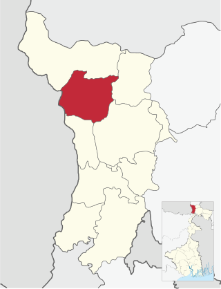
Darjeeling Sadar subdivision is a subdivision of the Darjeeling district in the state of West Bengal, India.

Pattabong Tea Garden is a village in the Darjeeling Pulbazar CD block in the Darjeeling Sadar subdivision of the Darjeeling district in the state of West Bengal, India.

<span class="mw-page-title-main">Ghum, West Bengal</span> Neighbourhood in Darjeeling, West Bengal, India

Ghum is a small hilly neighbourhood in the Darjeeling Himalayan hill region of West Bengal, India. It comes under ward number one of the Darjeeling Municipality. Ghum railway station of the Darjeeling Himalayan Railway is the highest railway station in India. It is situated at an altitude of 2,258 metres (7,407 ft). The place is the home of the Ghum Monastery and the Batasia Loop, a bend of the Darjeeling Himalayan Railway.

<span class="mw-page-title-main">Tonglu, West Bengal</span> Village in West Bengal, India

Tonglu is the one of the higher peaks of the Singalila Ridge and a small settlement inside the Singalila National Park in the Darjeeling subdivision, Darjeeling district in the state of West Bengal in India near the India - Nepal border. It is a roadside halt along the trekking route from Manebhanjan to Sandakphu.

<span class="mw-page-title-main">Manebhanjyang, Darjeeling</span> Transit-town in West Bengal, India

Maney Bhanjyang is a small transit-town in the Darjeeling Sadar subdivision, Darjeeling district in the state of West Bengal in India. It is located at the gateway of the Singalila National Park, 28 km away from Darjeeling town. The income of the local residents is geared towards tourism, especially foreign trekkers. Maney Bhanjyang is the start of the trailhead for the trek to Sandakphu on the Singalila Ridge, the highest point in West Bengal. Conveyance for Sandakphu is also available mainly from Maney Bhanjyang in the form of Land Rovers of 1960 model. The 4-hour ride can be quite 'jumpy' as drivers maneuver their prized possessions along snaky curves and uphill roads.

<span class="mw-page-title-main">Sukhia Pokhri</span> Census Town in West Bengal, India

Sukhia Pokhri is a census town in the Jorebunglow Sukhiapokhri CD block in the Darjeeling Sadar subdivision of the Darjeeling district in the indian state of West Bengal. It is located 11 km from Ghum on the way to Mirik.

Bijanbari is a village in Darjeeling Pulbazar CD block in the Darjeeling Sadar subdivision of the Darjeeling district in West Bengal, India. It is a place of importance in Darjeeling district mainly because of the Block Divisional Office and a Hydel Power Plant.

Rimbick is a village in the Darjeeling Pulbazar CD block in the Darjeeling Sadar subdivision of the Darjeeling district in West Bengal, India.

<span class="mw-page-title-main">Darjeeling Pulbazar (community development block)</span> Community development block in West Bengal, India

Darjeeling Pulbazar is a community development block that forms an administrative division in the Darjeeling Sadar subdivision of the Darjeeling district in the Indian state of West Bengal.

<span class="mw-page-title-main">Jorebunglow Sukhiapokhri (community development block)</span> Community development block in West Bengal, India

Jorebunglow Sukhiapokhri is a community development block that forms an administrative division in the Darjeeling Sadar subdivision of the Darjeeling district in the Indian state of West Bengal.

<span class="mw-page-title-main">Rangli Rangliot (community development block)</span> Community development block in West Bengal, India

Rangli Rangliot is a community development block that forms an administrative division in the Darjeeling Sadar subdivision of the Darjeeling district in the Indian state of West Bengal.

Ging Tea Garden is a census town in the Darjeeling Pulbazar CD block in the Darjeeling Sadar subdivision of the Darjeeling district in the state of West Bengal, India.

Chongtong Tea Garden is a census town in the Darjeeling Pulbazar CD block in the Darjeeling Sadar subdivision of the Darjeeling district in the state of West Bengal, India.

Singtam Tea Garden is a census town in the Darjeeling Pulbazar CD block in the Darjeeling Sadar subdivision of the Darjeeling district in the state of West Bengal, India.

Badamtam Tea Garden is a census town and a gram panchayat in the Darjeeling Pulbazar CD block in the Darjeeling Sadar subdivision of the Darjeeling district in the state of West Bengal, India.

Tukvar Tea Garden is a village in the Darjeeling Pulbazar CD block in the Darjeeling Sadar subdivision of the Darjeeling district in the state of West Bengal, India.

Singla Tea Garden is a village in the Darjeeling Pulbazar CD block in the Darjeeling Sadar subdivision of the Darjeeling district in the state of West Bengal, India.

Soom Tea Garden is a village in the Darjeeling Pulbazar CD block in the Darjeeling Sadar subdivision of the Darjeeling district in the state of West Bengal, India.

Rishihat Tea Garden is a village in the Darjeeling Pulbazar CD block in the Darjeeling Sadar subdivision of the Darjeeling district in the state of West Bengal, India.

Orange Valley Tea Garden is a village in the Darjeeling Pulbazar CD block in the Darjeeling Sadar subdivision of the Darjeeling district in the state of West Bengal, India.

References

  1. "Singalila National Park". Darjeeling Tourism. Retrieved 22 February 2020.
  2. Gurung, H. & Shrestha, R. K. (1994). Nepal Himalaya Inventory. Kathmandu: Ministry of Tourism and Civil Aviation.
  3. "Sandakphu-Phalut Trek". Himalayan High. Retrieved 21 March 2020.
  4. "Darjeeling". District Profile - General Information. District administration. Retrieved 21 March 2020.
  5. "District Statistical Handbook 2013 Darjeeling". Tables 2.2, 2.4b. Department of Planning and Statistics, Government of West Bengal. Retrieved 21 March 2020.
  6. "Darjeeling Tea". District administration. Retrieved 21 March 2020.
  7. "2011 Census – Primary Census Abstract Data Tables". West Bengal – District-wise. Registrar General and Census Commissioner, India. Retrieved 21 March 2020.
  8. "2011 Census – Primary Census Abstract Data Tables". West Bengal – District-wise. Registrar General and Census Commissioner, India. Retrieved 2 December 2016.
  9. "District Statistical Handbook 2013 Darjeeling". Tables 2.1, 2.2. Department of Statistics and Programme Implementation, Government of West Bengal. Retrieved 22 February 2020.
  10. "District Profile - Darjeeling". District administration. Retrieved 22 February 2020.
  11. "Rammam Hydroelectric Power Plant". Global Energy Observation. Retrieved 22 February 2020.
  12. "Health & Family Welfare Department" (PDF). Health Statistics – Primary Health Centres. Government of West Bengal. Retrieved 28 February 2020.