Bagdogra

Last updated • 3 min readFrom Wikipedia, The Free Encyclopedia

Bagdogra
Settlement
TEA GARDEN 1.jpg
Tea estate in Bagdogra
West Bengal location map.svg
Red pog.svg
Bagdogra
Location in West Bengal, India
India location map 3.png
Red pog.svg
Bagdogra
Bagdogra (India)
Asia laea location map.svg
Red pog.svg
Bagdogra
Bagdogra (Asia)
Coordinates: 26°42′N88°19′E / 26.700°N 88.317°E / 26.700; 88.317
CountryFlag of India.svg  India
State West Bengal
District Darjeeling
Subdivision Siliguri
Government
  BodyUpper Bagdogra Gram Panchayet / Lower Bagdogra Gram Panchayet
Area
  Total10 km2 (4 sq mi)
Elevation
136 m (446 ft)
Languages
  Official Bengali [1] [2]
  Additional officialEnglish [1]
Time zone UTC+5:30 (IST)
Area code 0353
Vehicle registration WB 73/74

Bagdogra is a settlement in the Naxalbari CD block in the Siliguri subdivision of the Darjeeling district, in the Indian state of West Bengal. It is a part of the Greater Siliguri Metropolitan Area. Bagdogra is well connected by air to six major cities of India – Delhi, Mumbai, Bengaluru, Hyderabad, Kolkata and Chennai through the Bagdogra Airport. The Bagdogra railway station is also well connected. [3]

Contents

Geography

Invisible Square.svg
Mapscaleline.svg
8km
5miles
Red pog.svg
N
E
P
A
L
B
A
N
G
L
A
D
E
S
H
Mahananda
River
Balason River
Mechi
River
Bagdogra Airport
F
Invisible Square.svg
Batasi
R
Invisible Square.svg
Phansidewa
R
Invisible Square.svg
Panitanki
R
Invisible Square.svg
Naxalbari
R
Invisible Square.svg
Bengdubi
R
Invisible Square.svg
Bagdogra
R
Uttar Bagdogra
CT
Invisible Square.svg
Shyamdhan
CT
Invisible Square.svg
Lalman
CT
Invisible Square.svg
Kharibari
CT
Invisible Square.svg
Geni
CT
Invisible Square.svg
Dakshin
Bagdogra
CT
Invisible Square.svg
Places in the south-western portion of Siliguri subdivision in Darjeeling district
CT: census town, R: rural/ urban centre, F: facilities
Owing to space constraints in the small map, the actual locations in a larger map may vary slightly

Location

Bagdogra is located at 26°25′N88°11′E / 26.42°N 88.19°E / 26.42; 88.19 . It is 11km away from Siliguri. It has two National Highways:- AH 2 and NH 31C. It also has Asian Highway (AH2).

Bagdogra International Airport Bagdogra International Airport.jpg
Bagdogra International Airport

Area overview

The map alongside shows the Siliguri subdivision of Darjeeling district. This area is spread across the foothills of the Himalayas and is a plain land gently sloping from north to south. While the northern part is mentioned as the Terai region, the larger southern portion forms the western part of the Dooars region. While 55.11% per cent of the population resides in the rural areas, 44.89% resides in the urban areas. On the western side the Mechi River forms a long border with Nepal. On the eastern side the Mahananda River forms a short border with Bangladesh. [4] [5] Note: The map alongside presents some of the notable locations in the subdivision. All places marked in the map are linked in the larger full screen map.

Climate

MonthJanFebMarAprMayJunJulAugSepOctNovDecYear
Record high °C (°F)32.5
(90.5)
33.2
(91.8)
38.1
(100.6)
41.7
(107.1)
40.8
(105.4)
41.9
(107.4)
40.4
(104.7)
40.0
(104.0)
40.1
(104.2)
36.6
(97.9)
33.8
(92.8)
32.6
(90.7)
41.9
(107.4)
Mean maximum °C (°F)25.6
(78.1)
27.9
(82.2)
32.8
(91.0)
34.9
(94.8)
35.3
(95.5)
36.3
(97.3)
36.0
(96.8)
36.7
(98.1)
35.8
(96.4)
33.5
(92.3)
30.4
(86.7)
27.2
(81.0)
37.0
(98.6)
Mean daily maximum °C (°F)22
(72)
24.5
(76.1)
29.3
(84.7)
30.8
(87.4)
29.9
(85.8)
29.5
(85.1)
29.1
(84.4)
29.6
(85.3)
29.2
(84.6)
28.5
(83.3)
26.3
(79.3)
23.4
(74.1)
27.7
(81.8)
Mean daily minimum °C (°F)10.7
(51.3)
12.8
(55.0)
16.1
(61.0)
19.5
(67.1)
22.1
(71.8)
24
(75)
24.6
(76.3)
24.6
(76.3)
23.5
(74.3)
19.7
(67.5)
15.2
(59.4)
11.8
(53.2)
18.7
(65.7)
Mean minimum °C (°F)6.9
(44.4)
7.2
(45.0)
12.5
(54.5)
16.5
(61.7)
18.6
(65.5)
22.0
(71.6)
23.4
(74.1)
23.6
(74.5)
21.9
(71.4)
16.8
(62.2)
11.9
(53.4)
7.7
(45.9)
6.5
(43.7)
Record low °C (°F)1.9
(35.4)
3.5
(38.3)
6.2
(43.2)
9.6
(49.3)
15.0
(59.0)
20.0
(68.0)
21.0
(69.8)
18.4
(65.1)
19.8
(67.6)
12.3
(54.1)
6.4
(43.5)
2.4
(36.3)
1.9
(35.4)
Average precipitation mm (inches)23
(0.9)
24
(0.9)
34
(1.3)
76
(3.0)
249
(9.8)
628
(24.7)
843
(33.2)
589
(23.2)
403
(15.9)
121
(4.8)
10
(0.4)
11
(0.4)
3,011
(118.5)
Average rainy days445111720212018822132
Average relative humidity (%)69655463798890888780706875
Average ultraviolet index 5791112131413118549
Source 1: normal temperatures [6] [7] Ultraviolet Index [8]
Source 2: Extremes(India Meteorological Department [9] ), Mean maximum and Mean minimum temperatures [10]

Civic administration

Police station

Bagdogra police station has jurisdiction over parts of Siliguri Municipal Corporation. [11] [12]

Transport

Airway

Bagdogra Airport Bagdogra International Airport - during LGFC - Bhutan 2019 (24).jpg
Bagdogra Airport

The Bagdogra International Airport (IATA: IXB, ICAO: VEBD) is located in about 16 km (9.9 mi) west of the city of Siliguri in the Darjeeling district in northern West Bengal, India. It is operated as a civil enclave at Air Force Station Bagdogra. It is the gateway airport to the hill station towns of Darjeeling, Kurseong, Mirik, and Kalimpong and the state of Sikkim, and sees thousands of tourists annually. Permits for Foreign tourists intending to journey to Sikkim are issued at this airport. And airport is a major stop in the region with flights connecting Kolkata, New Delhi, Mumbai, Bangalore, Chennai, Hyderabad, Guwahati, Paro and Bangkok. The airport also has regular helicopter flights to Gangtok, the capital of Sikkim. The central government of India conferred international airport status to the airport in 2002 with limited international operations.

Railway

Bagdogra Railway Station BORA.1.png
Bagdogra Railway Station

Bagdogra Railway Station comes under Northeast Frontier Railway zone (NFR) and Siliguri-Katihar Railway Line. The station code of Bagdogra is (BORA).

Roadway

It has two National Highways :- NH 31 and NH 31C. It also has Asian Highway (AH2) which is connected with Nepal and Bangladesh. It provides a gateway to North - East India.

Education

The University of North Bengal was established at Raja Rammohunpur in 1962. [13]

Kalipada Ghosh Tarai Mahavidyalaya was established at Bagdogra in 1988. Affiliated with the University of North Bengal, it offers honours courses in Bengali, Nepali, Hindi, English, geography, history, political science, sociology, accountancy, management, and general courses in arts, science and commerce. [14] [15]

Some of the notable schools near/in Bagdogra are Army Public School Bengdubi, Kendriya Vidyalaya Bengdubi, Kendriya Vidyalaya Air Force, Good Shepherd, Hebron English High School, Limelight School and B.S.F. Senior Secondary Residential School Kadamtala.

Related Research Articles

<span class="mw-page-title-main">Siliguri</span> Metropolis in West Bengal, India

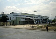
Siliguri is a major tier-II city in West Bengal. It forms "Twin Cities" with the neighbouring district capital of Jalpaiguri. The city spans areas of the Darjeeling and Jalpaiguri districts in the Indian state of West Bengal. Known as the "Gateway of Northeast India", Siliguri is popular for three Ts: tea, timber and tourism. It is located on the banks of the Mahananda River and the Teesta River at the foothills of the Himalayas. Siliguri is the third largest urban agglomeration in West Bengal, after Kolkata and Asansol.

Naxalbari is a village in the Naxalbari CD block in the Siliguri subdivision of the Darjeeling district in the state of West Bengal, India. Naxalbari is known for being the site of a 1967 revolt that eventually led to the Naxalite–Maoist insurgency.

<span class="mw-page-title-main">Malbazar</span> Town in West Bengal, India

Malbazar, also known as Mal, is a town and a municipality in Jalpaiguri district in the state of West Bengal, India. It is the headquarters of the Malbazar subdivision. It lies about 65 km from Jalpaiguri and 55 km from Siliguri. It lies on the bank of river Neora.

<span class="mw-page-title-main">Singtam</span> Town in Sikkim, India

Singtam is a town which lies mostly in Gangtok District and partly in Pakyong District in the Indian state of Sikkim about 30 kilometres (19 mi) from the state capital Gangtok. The town lies on the banking of the rivers Teesta and Ranikhola, which join together just below the town. NH10 and NH510 meet in Singtam. The Indreni Bridge and Sherwani Bridge over the river Teesta are in the town. Singtam District Hospital, the district hospital of Pakyong District, lies at Golitar, Singtam.

Uttar Bagdogra is a census town in the Siliguri subdivision of the Darjeeling district in the Indian state of West Bengal.

<span class="mw-page-title-main">Sevoke</span> Town near Siliguri, West Bengal, India

Sevoke is a small town near Siliguri in the Darjeeling district of West Bengal state of India near the border with Sikkim state. Situated in Dooars, Sevoke lies on the bank of River Teesta and has two bridges − namely Coronation Bridge and Sevoke Railway Bridge over it. Indian Army and Border Security Force camps are located in the area. The Mahananda Wildlife Sanctuary is situated in this area. National Highway NH10 passes through the town and connects Sevoke town to Gangtok and Siliguri. National Highway 17 originates from Sevoke near Coronation Bridge and terminates in Guwahati.

<span class="mw-page-title-main">Siliguri subdivision</span> Subdivision in West Bengal, India

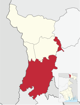
Siliguri subdivision is a subdivision of the Darjeeling district in the state of West Bengal, India.

<span class="mw-page-title-main">Naxalbari (community development block)</span> Community development block in West Bengal, India

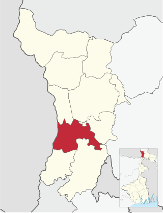
Naxalbari is a community development block that forms an administrative division in the Siliguri subdivision of the Darjeeling district in the Indian state of West Bengal.

Kharibari is a census town in the Kharibari CD block in the Siliguri subdivision of the Darjeeling district in the state of West Bengal, India.

Kalipada Ghosh Tarai Mahavidyalaya, also known as Bagdogra College, established in 1988, is the general degree college in Bagdogra. It offers undergraduate courses in arts, commerce and science. The campus is in the Darjeeling district. It is affiliated to University of North Bengal.

<span class="mw-page-title-main">Panitanki</span> Neighbourhood in Darjeeling, West Bengal, India

Panitanki is a town in Darjeeling district of West Bengal, India. It is located on the India-Nepal border; a border crossing to Kakarbhitta in Nepal is located here.

Phansidewa is a village in the Phansidewa CD block in the Siliguri subdivision of the Darjeeling district in the state of West Bengal, India.

<span class="mw-page-title-main">Batasi</span> Village in West Bengal, India

Batashi is a village in Kharibari CD block in Siliguri subdivision of Darjeeling district of West Bengal, India.

Shyamdhan is a census town in the Kharibari CD block in the Siliguri subdivision of Darjeeling district in the state of West Bengal, India.

Dumriguri is a census town in the Naxalbari CD block in the Siliguri subdivision of Darjeeling district in the state of West Bengal, India.

Bengdubi is a military station in the Naxalbari CD block in the Siliguri subdivision of Darjeeling district in the state of West Bengal, India.

Geni is a census town in the Naxalbari CD block in the Siliguri subdivision of Darjeeling district in the state of West Bengal, India.

Bhimram is a census town in the Naxalbari CD block in the Siliguri subdivision of Darjeeling district in the state of West Bengal, India.

Lalman is a census town in the Naxalbari CD block in the Siliguri subdivision of Darjeeling district in the state of West Bengal, India.

Dakshin Bagdogra is a census town in the Naxalbari CD block in the Siliguri subdivision of Darjeeling district in the state of West Bengal, India.

References

  1. 1 2 "Fact and Figures". www.wb.gov.in. Retrieved 15 January 2019.
  2. "52nd Report of the Commissioner for Linguistic Minorities in India" (PDF). nclm.nic.in. Ministry of Minority Affairs. p. 85. Archived from the original (PDF) on 25 May 2017. Retrieved 15 January 2019.
  3. Kumar, Brajesh (2003). Pilgrimage Centers of India. New York: Diamond Pocket Books. p. 170. ISBN   81-7182-185-5 . Retrieved 28 May 2009.
  4. "District Census Handbook, Darjeeling, Series 20, Part XII A, 2011 Census of India" (PDF). Page 13: Physiography. Directorate of Census Operations, West Bengal. Retrieved 29 March 2020.
  5. "District Census Handbook, Darjeeling, Series 20, Part XII A, 2011 Census of India" (PDF). Pages 15-17: Drainage. Directorate of Census Operations, West Bengal. Retrieved 29 March 2020.
  6. "Climate data for Siliguri". en.climate-data.org. Retrieved 8 June 2023.
  7. "Regional Meteorological Department, Kolkata" . Retrieved 7 December 2020.
  8. "Average UV Index for Siliguri" . Retrieved 7 December 2020.
  9. "Extremes of Temperature & Rainfall for Indian Stations (Up to 2012)" (PDF). India Meteorological Department. December 2016. p. M229. Archived from the original (PDF) on 5 February 2020. Retrieved 21 October 2020.
  10. "Climate for Siliguri city" . Retrieved 3 December 2020.
  11. "District Statistical Handbook 2013 Darjeeling". Tables 2.1, 2.2. Department of Statistics and Programme Implementation, Government of West Bengal. Archived from the original on 21 January 2019. Retrieved 22 February 2020.
  12. "District Profile - Darjeeling". District administration. Archived from the original on 17 August 2015. Retrieved 22 February 2020.
  13. "University of North Bengal". NBU. Retrieved 24 February 2020.
  14. "Kalipada Ghosh Tarai Mahavidyalaya". KGTM. Retrieved 24 February 2020.
  15. "Kalipada Ghosh Tarai Mahavidyalaya". Careers360. Retrieved 24 February 2020.