
Lees Creek, also known as Centerville, is an unincorporated community in central Wayne Township, Clinton County, Ohio, United States. It lies at the intersection of State Route 729 with Cox Road, 6 miles south of Sabina and 12 miles (19 km) southeast of Wilmington, the county seat of Clinton County. It lies between the headwaters of the Middle Fork of Lees Creek, to the southeast, and the Anderson Fork of Caesar Creek. it had a post office, with the ZIP code 45138. The Post Office closed in 2012 and the town, including East Clinton High School, now carries a Sabina mailing address.

Roundhead is an unincorporated community in southeastern Roundhead Township, Hardin County, Ohio, United States. It has a post office with the ZIP code 43346.

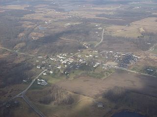
Haydenville is an unincorporated community and census-designated place (CDP) in southern Green Township, Hocking County, Ohio, United States. As of the 2010 census the population of the CDP was 381.
Springhills is an unincorporated community in northwestern Harrison Township, Champaign County, Ohio, United States. It lies at the intersection of State Route 245 with Crowl and Springhill-DeGraff Roads. Graves Creek, a subsidiary of the Great Miami River through Stony Creek, runs along the western edge of Springhills. It is located 6 miles (9.5 km) west of West Liberty and 11.5 miles (18.5 km) northwest of Urbana, the county seat of Champaign County.
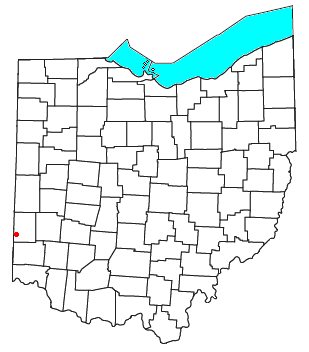
Fairhaven is an unincorporated community in eastern Israel Township, Preble County, Ohio, United States. It lies along State Route 177 at its intersection with Israel-Somers Road. Four Mile Creek, which feeds into Acton Lake in southern Preble County, runs on the western edge of Fairhaven. It is located 10½ miles southwest of Eaton, the county seat of Preble County. The community is part of the Dayton Metropolitan Statistical Area. Fairhaven Church and Fairhaven Community Church are both located in Fairhaven along State Route 177. Fairhaven Community Church hosts a free annual Dinner Drama for the community. Fairhaven is home to the historic Bunker Hill house, a stop along the Underground Railroad.
New Somerset is an unincorporated community in northern Knox Township, Jefferson County, Ohio, United States. It lies south of Hammondsville along State Route 213, at 40°30′57″N80°42′21″W.
Hepburn is an unincorporated community in northern Dudley Township, Hardin County, Ohio, United States. It lies at the intersection of County Roads 144 and 227, 7+1⁄2 miles (12.1 km) east of the center of the city of Kenton, the county seat of Hardin County. Along the south side of the community runs the Scioto River. The community is served by the Kenton (43326) post office.

Kennard is an unincorporated community in eastern Salem Township, Champaign County, Ohio, United States. It lies at the intersection of Gray and Kennard Roads, less than 2 miles southwest of State Route 245. The headwaters of Kings Creek, a tributary of the Mad River, flow past Kennard. It is located approximately 10 miles (16 km) northwest of the city of Urbana, the county seat of Champaign County.

Millerstown is an unincorporated community in eastern Johnson Township, Champaign County, Ohio, United States. It lies at the intersection of Heck Hill, Ward, and Zimmerman Roads, 2+1⁄2 miles (4.0 km) north of U.S. Route 36. Nettle Creek, a tributary of the Mad River, flows past Millerstown. It is located approximately 4 miles northeast of the city of St. Paris and 10 miles (16 km) west-northwest of the city of Urbana, the county seat of Champaign County.

Brokensword is an unincorporated community on the border between the Holmes and Lykens townships of Crawford County, Ohio, United States. Located at the intersection of the concurrent State Routes 19 and 100 with Brokensword Road, it is six miles north and two miles west of the city of Bucyrus, the county seat. Broken Sword Creek flows a short distance to the south of the community.

Bridgeport is an unincorporated community in far western Darby Township, Union County, Ohio, United States. It lies at the intersection of State Route 38 with Orchard Road, midway between the villages of Milford Center and Unionville Center. At Bridgeport, Buck Run meets the Big Darby Creek, which meets the Scioto River at Circleville. It is located 6 miles (9.7 km) south of Marysville, the county seat of Union County.

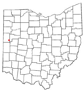
Westminster is an unincorporated community in western Auglaize Township, Allen County, Ohio, United States. It lies along State Route 117 just north of its intersection with State Route 196, 6½ miles north of Waynesfield and 7+1⁄2 miles (12.1 km) southeast of the downtown part of the city of Lima, the county seat of Allen County. The upper reaches of the Auglaize River flow past the community.

Tawawa is an unincorporated community in northeastern Green Township, Shelby County, Ohio, United States. It lies along State Route 29 less than one mile away from the Champaign County border. Mosquito Creek, a tributary of the Great Miami River, flows northwestward along the southern edge of Tawawa. The community lies 8 miles southeast of the city of Sidney, the county seat of Shelby County.

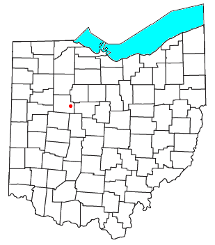
Roxabell is an unincorporated community in central Concord Township, Ross County, Ohio, United States. It lies at the intersection of Davis Hill and Jamison Roads, little more than 1 mile south of the village of Frankfort. Two parts of the North Fork of Paint Creek, a subsidiary of the Ohio River through the Scioto River, pass near Roxabel. It is located slightly more than 3 miles north of State Route 28, midway between the cities of Chillicothe — the county seat of Ross County — and Greenfield.

Footville is an unincorporated community in southwestern Trumbull Township, Ashtabula County, Ohio, United States. It lies at the intersection of State Route 166 with Trask Road, 1+1⁄2 miles (2.4 km) east of the Geauga County line and 11+1⁄4 miles (18.1 km) southeast of the village of Jefferson, the county seat of Ashtabula County. Spring and Trumbull Creeks, which are both tributaries of the Grand River, pass near Footville.

Assumption is a small unincorporated community and also a historically Irish (Catholic) community in southern Amboy Township, Fulton County, Ohio, United States. A part of the Toledo Metropolitan Area, it lies seven miles from the northern edge of Swanton. It is located at roughly 41°40'N, 83°55'W.

Thackery is an unincorporated community in southeastern Jackson and southwestern Mad River Townships in Champaign County, Ohio, United States. It lies along State Route 55, southwest of the city of Urbana, the county seat of Champaign County.
Sebastian is an unincorporated community in northern Marion Township, Mercer County, Ohio, United States. Its elevation is 932 feet (284 m), and it is located at 40°26′39″N84°31′0″W. Located at the intersection of Sebastian Road and County Road 716-A, the community lies south of the city of Celina, the county seat of Mercer County, and nearly 2 miles (3.2 km) northwest of the village of Chickasaw.

Cassella is an unincorporated community in Marion Township, Mercer County, Ohio, United States. Located at 40°24′22″N84°33′8″W, it lies at an elevation of 955 feet (291 m). Situated at the intersection of State Route 119 and Cassella-Montezuma Road in western Marion Township, it lies in the headwaters of Beaver Creek to the south of the city of Celina, the county seat of Mercer County. Other nearby communities include Maria Stein, 3 miles (4.8 km) to the east, Carthagena, 2 miles (3.2 km) to the north, and St. Henry, 4 miles (6.4 km) to the west.
McCartyville is an unincorporated community in Shelby County, Ohio, United States. Located at the junction of State Routes 29 and 119, it lies in southern Van Buren Township, 3 miles (4.8 km) south of central Kettlersville and approximately 8 miles (13 km) northwest of the city of Sidney, the county seat of Shelby County. Its elevation is 974 feet (297 m), and it is located at 40°23′41″N84°15′21″W.


