
East Liberty is a census-designated place located in southern Perry Township, Logan County, Ohio, United States. It is located just off U.S. Route 33, east of Bellefontaine and about an hour northwest of Columbus. Although it is unincorporated, it has a post office, with the ZIP code of 43319.

Lees Creek, also known as Centerville, is an unincorporated community in central Wayne Township, Clinton County, Ohio, United States. It lies at the intersection of State Route 729 with Cox Road, 6 miles south of Sabina and 12 miles (19 km) southeast of Wilmington, the county seat of Clinton County. It lies between the headwaters of the Middle Fork of Lees Creek, to the southeast, and the Anderson Fork of Caesar Creek. Although it is unincorporated, it had a post office, with the ZIP code of 45138. The Post Office closed in 2012 and the town, including East Clinton High School, now carries a Sabina mailing address.

Roundhead is an unincorporated community in southeastern Roundhead Township, Hardin County, Ohio, United States. Although it is unincorporated, it has a post office, with the ZIP code of 43346.

Johnsville, also known as Shauck, is an unincorporated community in northern Perry Township, Morrow County, Ohio, United States. Although it is unincorporated, it has a post office, with the ZIP code of 43349. It is located at the intersection of U.S. Route 42 with State Route 314.

Raymond is a census-designated place in eastern Liberty Township, Union County, Ohio, United States. Although it is unincorporated, it has a post office, with the ZIP code of 43067. It is located at the intersection of State Routes 347 and 739.
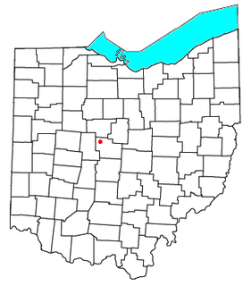
Radnor is an unincorporated community and census-designated place (CDP) in central Radnor Township, Delaware County, Ohio, United States. As of the 2010 census it had a population of 201. Radnor has a post office with the ZIP code of 43066. It lies along State Route 203 at its intersection with Radnor Road.

Damascus is a census-designated place (CDP) in southwestern Goshen Township in Mahoning County and northwestern Butler Township in Columbiana County in the U.S. state of Ohio. As of the 2010 census, it had a population of 443. Damascus has a post office, with the ZIP code of 44619. The Mahoning County portion of Damascus is part of the Youngstown-Warren-Boardman, OH-PA Metropolitan Statistical Area, while the Columbiana County portion is part of the Salem, OH Micropolitan Statistical Area.

Haydenville is an unincorporated community and census-designated place (CDP) in southern Green Township, Hocking County, Ohio, United States. As of the 2010 census the population of the CDP was 381.
Wingett Run is an unincorporated community in western Ludlow Township, Washington County, Ohio, United States. Although it is unincorporated, it has a post office, with the ZIP code 45789. It is located along State Route 26 and the Little Muskingum River.

Whipple is an unincorporated community in southern Salem Township, Washington County, Ohio, United States. Although it is unincorporated, it once had a post office, with the ZIP code of 45788. It lies on State Route 821 south of the village of Lower Salem, at the junction of Whipple Run with Duck Creek. The community took its name from nearby Whipple Run.

Watertown is an unincorporated community in southwestern Watertown Township, Washington County, Ohio, United States. Although it is unincorporated, it has a post office, with the ZIP code of 45787. It lies near the intersection of State Routes 339 and 676 near Wolf Creek, which meets the Muskingum River at Waterford to the north.

Vincent is a census-designated place in southern Barlow Township, Washington County, Ohio, United States. Although it is unincorporated, it has a post office, with the ZIP code of 45784. It lies along State Route 339 near Tupper Creek, a subsidiary of the Little Hocking River, which in turn meets the Ohio River at Little Hocking to the south.

Reno is a census-designated place in southern Marietta Township, Washington County, Ohio, United States. Although it is unincorporated, it has a post office, with the ZIP code of 45773. It is located on the Ohio River a short distance above the county seat of Marietta. State Route 7 forms its main street.

Newport is a census-designated place in eastern Newport Township, Washington County, Ohio, United States. Although it is unincorporated, it has a post office, with the ZIP code of 45768. Newport lies along the Ohio River several miles above the county seat of Marietta. Its main street is formed by State Route 7.

Little Hocking is a census-designated place in southern Belpre Township, Washington County, Ohio, United States. Although it is unincorporated, it has a post office, with the ZIP code of 45742.
Cutler is an unincorporated community in southwestern Fairfield Township, Washington County, Ohio, United States. Although it is unincorporated, it has a post office, with the ZIP code of 45724. It lies at the intersection of State Route 555 and County Road 59 near Gilbert Run, a subsidiary of the Little Hocking River, which meets the Ohio River at Little Hocking to the southeast.

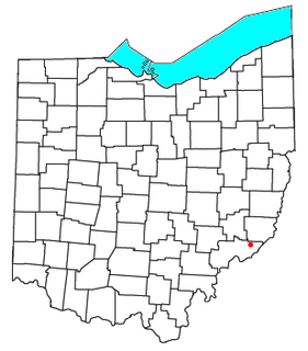
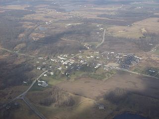
Bartlett is an unincorporated community in southwestern Wesley Township, Washington County, Ohio, United States. Although it is unincorporated, it has a post office, with the ZIP code of 45713. It sits at the intersection of State Routes 550 and 555 near Coal Run, a subsidiary of Wolf Creek, which meets the Muskingum River at Waterford to the north. Near Bartlett is located the Shinn Covered Bridge, which spans Wolf Creek.

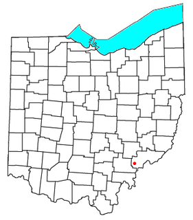
Barlow is an unincorporated community in western Barlow Township, Washington County, Ohio, United States. Although it is unincorporated, it has a ZIP code of 45712. It lies at the intersection of State Routes 339 and 550 near the South Fork of Wolf Creek, which meets the Muskingum River at Waterford to the north.

Kansas is a census-designated place in northwestern Liberty Township, Seneca County, Ohio, United States. Although it is unincorporated, it has a post office, with the ZIP code of 44841. It is located along State Route 635.
Springhills is an unincorporated community in northwestern Harrison Township, Champaign County, Ohio, United States. It lies at the intersection of State Route 245 with Crowl and Springhill-DeGraff Roads. Graves Creek, a subsidiary of the Great Miami River through Stony Creek, runs along the western edge of Springhills. It is located 6 miles (9.5 km) west of West Liberty and 11.5 miles (18.5 km) northwest of Urbana, the county seat of Champaign County.


