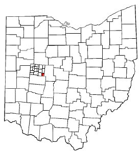
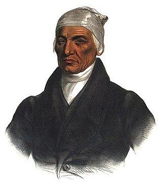
Logan County is a county located in the west central portion of the U.S. state of Ohio. As of the 2020 census, the population was 46,150. The county seat is Bellefontaine. The county is named for Benjamin Logan, who fought Native Americans in the area.
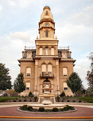
Bellefontaine is a city in and the county seat of Logan County, Ohio, United States, located 48 miles (77 km) northwest of Columbus. The population was 13,370 at the 2010 Census. It is the principal city of the Bellefontaine, OH Micropolitan Statistical Area, which includes all of Logan County. The highest point in Ohio, Campbell Hill, is within the city limits.

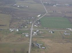
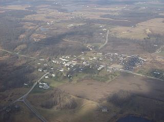
East Liberty is an unincorporated community and census-designated place (CDP) located in Perry Township, Logan County, Ohio, United States. As of the 2010 census, it had a population of 366. It is located just off U.S. Route 33, 10 miles (16 km) east of Bellefontaine and 46 miles (74 km) northwest of Columbus. It has a post office with the ZIP code 43319.
Duchouquet Township is one of the fourteen townships of Auglaize County, Ohio, United States. The 2020 census found 14,676 people in the township.
Zane Township is one of the seventeen townships of Logan County, Ohio, United States. As of the 2010 census, the population was 1,140, up from 968 at the 2000 census.

Monroe Township is one of the seventeen townships of Logan County, Ohio, United States. As of the 2010 census, the population was 1,739, up from 1,503 at the 2000 census.

Liberty Township is one of the seventeen townships of Logan County, Ohio, United States. As of the 2010 census, the population was 3,434, up from 3,126 at the 2000 census.
Jefferson Township is one of the seventeen townships of Logan County, Ohio, United States. As of the 2010 census, the population was 2,912.

Perry Township is one of the seventeen townships of Logan County, Ohio, United States. As of the 2010 census, the population was 992.

Richland Township is one of the seventeen townships of Logan County, Ohio, United States. As of the 2010 census, the population was 2,482.

Lewistown is an unincorporated community and census-designated place (CDP) in central Washington Township, Logan County, Ohio, United States. As of the 2010 census, the population was 222.

Logan Township is one of the fourteen townships of Auglaize County, Ohio, United States. The 2020 census found 1,158 people in the township.
Wakatomika was the name of two 18th century Shawnee villages in what is now the U.S. state of Ohio. The name was also spelled Wapatomica, Waketomika, Waketomica, and Waketameki, among other variations, but the similar name Wapakoneta was a different Shawnee village. Both Wakatomikas were destroyed in raids, the first by colonial Virginians in 1774, the second by Kentuckians in 1786.
The Logan County District Library is a public library system that serves communities throughout Logan County, Ohio, United States.

Salem Township is one of the twelve townships of Champaign County, Ohio, United States. The 2020 census reported 2,488 people living in the township.
Mekoche was the name of one of the five divisions of the Shawnee, a Native American people, during the 18th century. The other four divisions were the Chalahgawtha, Kispoko, Pekowi, and Hathawekela. Together these divisions formed the loose confederacy that was the Shawnee tribe.
Springhills is an unincorporated community in northwestern Harrison Township, Champaign County, Ohio, United States. It lies at the intersection of State Route 245 with Crowl and Springhill-DeGraff Roads. Graves Creek, a subsidiary of the Great Miami River through Stony Creek, runs along the western edge of Springhills. It is located 6 miles (9.5 km) west of West Liberty and 11.5 miles (18.5 km) northwest of Urbana, the county seat of Champaign County.

Logansville is an unincorporated community in central Pleasant Township, Logan County, Ohio, United States. It lies along State Route 47 at its intersection with County Road 24. The Great Miami River flows southward along the western edge of Logansville. The community lies 2+1⁄2 miles (4 km) north of the village of De Graff and 9 miles west of the city of Bellefontaine, the county seat of Logan County. It is located at 40°20′44″N83°55′50″W, and its altitude is 1,010 feet (308 m).
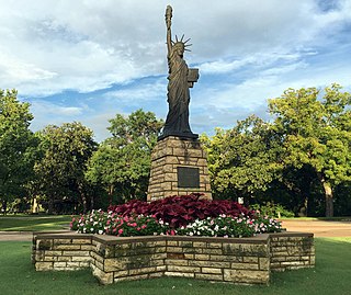
Strengthen the Arm of Liberty is the theme of the Boy Scouts of America's fortieth anniversary celebration in 1950. The campaign was inaugurated in February with a dramatic ceremony held at the base of the Statue of Liberty. Approximately 200 BSA Statue of Liberty replicas were installed across the United States.

The McColly Covered Bridge is a historic wooden covered bridge in western Logan County, Ohio, United States. Located in Washington Township near the community of Bloom Center, it is one of two remaining covered bridges in Logan County. It carries County Road 13 over the Great Miami River, approximately 5 miles (8.0 km) south of its source at Indian Lake.