
Pimpri Chinchwad, Pune is the northwestern city limits of Pune, India. Geographically, it is located at an altitude 590 m (1,940 ft) above sea level, at a distance of about 15 km (9.3 mi) northwest of its historic centre. The neighbourhood is home to extensive industry and is well known for its automotive, IT and manufacturing industry.

Pune district is the most populous district in the Indian state of Maharashtra. The district's population was 9,429,408 in the 2011 census, making it the fourth most populous district amongst India's 640 districts. This district has an urban population of 58.08 percent of its total. It is one of the most industrialized districts in India. In recent decades it has also become a hub for information technology.
Raigad district, previously Colaba district, is a district in the Konkan division of Maharashtra, India.

Dehu is a neighbourhood in the city of Pune, India. It is known for being the abode of Sant Tukaram.
Talegaon is a town on the outskirts of the city of Pune, India.

Vadgaon or Vadgaon Maval is a census town and nagar panchayat in Mawal taluka, Pune district, in the Indian state of Maharashtra. Vadgaon is famous for its Jain and Potoba Maharaj temples and Mhadaji shinde garden.
Chakan is a census town in India, in Pune district of the Indian state of Maharashtra. While agriculture remains an important factor, the town's industrial development is quickly urbanizing the area.
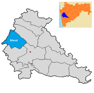
Maval taluka is a taluka in Mawal subdivision of Pune district of state of Maharashtra in India.
Koregaon Bhima is a panchayat village and census town in the state of Maharashtra, India, on the left (north) bank of the Bhima River. Administratively, Koregaon Bhima is under Shirur Taluka of Pune District in Maharashtra. There is only the single town of Koregaon Bhima in the Koregaon Bhima gram panchayat. The town of Koregaon Bhima is 10 km along the SH 60 motorway southwest of the village of Shikrapur, and 28 km by road northeast of the city of Pune. It is the site of the Battle of Koregaon fought on 1 January 1818.
Talegaon Dhamdhere is a panchayat village in the state of Maharashtra, India, on the right (south) bank of the Vel River. Administratively, Talegaon Dhamdhere is under Shirur Taluka of Pune District in Maharashtra. There is only the single village of Talegaon Dhamdhere in the Talegaon Dhamdhere gram panchayat. The village of Talegaon Dhamdhere is 4 km by road southeast of the village of Shikrapur, and 6 km by road north of the village of Vittalwadi.
Adhale Budruk is a village and gram panchayat in India, situated in Mawal taluka of Pune district in the state of Maharashtra. It encompasses an area of 872 ha.
The 2011 Census of India lists two villages called Brahmanwadi in Mawal taluka, Pune district, in the state of Maharashtra. Both form a part of the Karanjgaon gram panchayat and are listed separately from the village of Brahman Wadi in the same taluka.
Gahunje is a village and gram panchayat in Pune district of Maharashtra, India. It is situated in Mawal taluka of Pune district in the state of Maharashtra. It encompasses an area of 505.26 ha.
Ghonshet is a village and gram panchayat in India, situated in Mawal taluka of Pune district in the state of Maharashtra. It encompasses an area of 369.77 ha.
Kalhat is a village and gram panchayat in India, situated in Mawal taluka of Pune district in the state of Maharashtra. It encompasses an area of 1,070 ha.
Kivale is a village in India, situated in the Mawal taluka of Pune district in the state of Maharashtra. It encompasses an area of 1,261 ha.
Malewadi is a village in India, situated in Mawal taluka of Pune district in the state of Maharashtra. It encompasses an area of 431.92 ha.
Sangavi is a village in India, situated in the Baramati taluka on the river of nira of Pune district in the state of Maharashtra. It encompasses an area of 400.03 ha.
Mangdari is a village in Velhe Taluka in the Pune District of Maharashtra, India.
Jambhali is a village in the Bhor taluka in the Pune District of Maharashtra, India.

