
The Lizard is a peninsula in southern Cornwall, England, United Kingdom. The most southerly point of the British mainland is near Lizard Point at SW 701115; Lizard village, also known as The Lizard, is the most southerly on the British mainland, and is in the civil parish of Landewednack, the most southerly parish. The valleys of the River Helford and Loe Pool form the northern boundary, with the rest of the peninsula surrounded by sea. The area measures about 14 by 14 miles. The Lizard is one of England's natural regions and has been designated as a National Character Area 157 by Natural England. The peninsula is known for its geology and for its rare plants and lies within the Cornwall Area of Outstanding Natural Beauty (AONB).

Helston is a town and civil parish in Cornwall, England, United Kingdom. It is situated at the northern end of the Lizard Peninsula approximately 12 miles (19 km) east of Penzance and 9 miles (14 km) south-west of Falmouth. Helston is the most southerly town on the island of Great Britain and is around 1.5 miles (2.4 km) farther south than Penzance. The population in 2011 was 11,700.

London Apprentice is a village in south Cornwall, England, UK, on the banks of St Austell River in the Pentewan Valley approximately two miles (3 km) south of St Austell.

Gunwalloe is a coastal civil parish in Cornwall, England, United Kingdom. It is situated on the Lizard Peninsula three miles (4.8 km) south of Helston and partly contains The Loe, the largest natural freshwater lake in Cornwall. The parish population including Berepper at the 2011 census was 219. The hamlets in the parish are Chyanvounder, Berepper and Chyvarloe. To the east are the Halzephron cliffs and further east the parish church.

Angarrack is a village in west Cornwall, England, UK. It is in the parish of Gwinear-Gwithian a mile to the east of Hayle. Immediately south of the village Angarrack viaduct carries the Cornish mainline railway over the Angarrack River. The name comes from An Garrek which means "The Rock" in the Cornish language. According to the Ordnance Survey the spelling is Angarrack but on signs near the village, it is variously spelled Angarrack, Angharrack, or Angarrick.

Crowan is a village and civil parish in Cornwall, United Kingdom. It is about three-and-a-half miles (6 km) south of Camborne. A former mining parish, all of the mines had shut by 1880.
St Anthony-in-Meneage is a coastal civil parish and village in Cornwall, England, United Kingdom. The parish is in the Meneage district of the Lizard peninsula. In the 2001 census the parish had a population of 171, decreasing to 168 at the 2011 census.
Coverack Bridges is a hamlet in southwest Cornwall, England, United Kingdom. It is situated southwest of Wendron in the valley of the River Cober just under one mile north of Helston. The area is mainly farming now but has a long history of well over 200 years of granite quarry. The local quarry is still in business and is located just below the golf course along the banks of the River Cober.
Poldark Mine is a tourist attraction near the town of Helston in Cornwall, England, UK. It lies within the Wendron Mining District of the Cornwall and West Devon Mining Landscape World Heritage Site. Its features include underground guided tours through ancient tin mine workings, a museum of industrial heritage, mining equipment and Cornish social history, a scheduled ancient monument and riverside gardens.
Bodilly is a hamlet in south Cornwall, England, United Kingdom, that lends its name to neighbouring farms and settlements. It is situated in the civil parish of Wendron approximately 1 mile (1.6 km) northwest of Wendron. The hamlet itself is at grid reference SW 669 322, but the name Bodilly generally covers the area northwest of Wendron.

Otterham is a village and a civil parish in north Cornwall, England, United Kingdom. The village is situated approximately ten miles (16 km) south of Bude and six miles (9.7 km) north of Camelford.

Lanteglos is a coastal civil parish in south Cornwall, England, United Kingdom. It is on the east side of the tidal estuary of the River Fowey which separates it from the town and civil parish of Fowey. The South West Coast Path runs along the southern coasts of the parish and much of the southern part of the parish lies in the Polruan to Polperro Site of Special Scientific Interest managed by the National Trust.
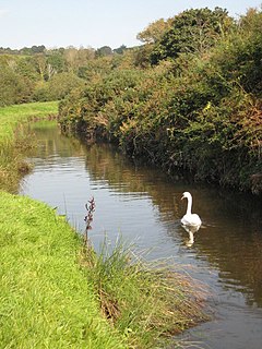
The River Cober is a short river in west Cornwall, England, United Kingdom. The river runs to the west of Helston into The Loe, Cornwall's largest natural lake.

The Helston Railway is a heritage railway in Cornwall which aims to rebuild and preserve as much as possible of the former GWR Helston Railway between Nancegollen and Water-Ma-Trout on the outskirts of Helston. It is operated by the Helston Railway Preservation Company using members of the Helston Railway Preservation Society.

The Loe, also known as Loe Pool, is the largest natural freshwater lake in Cornwall, United Kingdom. The earliest recorded appearance of this simple name form was in 1337, when it was called "La Loo", but is mentioned as 'the lake' in 1302; Situated between Porthleven and Gunwalloe and downstream of Helston, it is separated from Mount's Bay by the shingle bank of Loe Bar. Both the Loe and Loe Bar are situated within the Penrose Estate, which is administered by the National Trust, and are designated as a Site of Special Scientific Interest by Natural England. It is within the Cornwall Area of Outstanding Natural Beauty and is considered a classic Geological Conservation Review Site. The South West Coast Path, which follows the coast of south-west England from Somerset to Dorset passes over Loe Bar.

Degibna is a hamlet and farm in the parish of Helston, Cornwall, England, UK. It lies on the eastern bank of the largest natural freshwater lake in Cornwall, The Loe, and forms part of the Penrose Estate.
Norris Green is a village in Cornwall, England, UK. It was enlarged from a farming hamlet so that it now adjoins the neighbouring village of Higher Metherell. Both settlements are within the civil parish of Calstock which borders the River Tamar, the county boundary with Devon in south-east Cornwall.

Rinsey is a hamlet in Cornwall, England, United Kingdom. It is located off the main A394 road between Helston and Penzance in the civil parish of Breage. The nearby hamlet of Rinsey Croft is located 1 km to the north-east. The nearby cliffs and beach are owned and managed by the National Trust and part of Rinsey East Cliff is designated as the Porthcew Site of Special Scientific Interest (SSSI) for its geological interest. The South West Coast Path passes through the property. Rinsey lies within the Cornwall Area of Outstanding Natural Beauty (AONB).

Pancrasweek is a civil parish and hamlet in the far west of Devon, England forming part of the local government district of Torridge and lying about three miles north west of the town of Holsworthy.
Gwavas is a hamlet in the parish of Sithney, Cornwall, United Kingdom. Gwavas is adjoining Lowertown-by-Helston. The hamlet is a rural farming hamlet which once had a shop. Gwavas is 1.5 miles (2.4 km) northwest of Helston.

