
Albuquerque, also known as ABQ, Burque, and the Duke City, is the most populous city in the U.S. state of New Mexico. Founded in 1706 as La Villa de Alburquerque by Santa Fe de Nuevo México governor Francisco Cuervo y Valdés, and named in honor of Francisco Fernández de la Cueva, 10th Duke of Alburquerque and Viceroy of New Spain, it served as an outpost on El Camino Real linking Mexico City to the northernmost territories of New Spain.

Los Ranchos de Albuquerque, also known simply as "Los Ranchos", is a village in Bernalillo County, New Mexico. The population was 6,024 at the time of the 2010 Census.

Socorro is a city in Socorro County in the U.S. state of New Mexico. It is in the Rio Grande Valley at an elevation of 4,579 feet (1,396 m). In 2010 the population was 9,051. It is the county seat of Socorro County. Socorro is located 74 miles (119 km) south of Albuquerque and 146 miles (235 km) north of Las Cruces.
Tiwa is a group of two, possibly three, related Tanoan languages spoken by the Tiwa Pueblo, and possibly Piro Pueblo, in the U.S. state of New Mexico.

San Antonio is a census-designated place in Socorro County, New Mexico, United States, roughly in the center of the state, on the Rio Grande.
The Piro people were a Native American tribe who lived in New Mexico during the 16th and 17th century. The Piros lived in a number of pueblos in the Rio Grande Valley around modern Socorro, New Mexico, USA. The now extinct Piro language may have been a Tanoan language. Numbering several thousand at the time of first contact with the Spanish, by the time of the Pueblo Revolt in 1680 the Piro had been decimated by European-introduced diseases and Apache attacks and most of the survivors resettled near El Paso, Texas.

San Miguel de Socorro is the Catholic church in Socorro, New Mexico, built on the ruins of the old Nuestra Señora de Socorro mission. The old mission was built around 1627, but was destroyed in 1680 during the Pueblo Revolt. A portion of the adobe wall of the old church remains today and still can be seen behind glass just left of the altar. The building was listed on the National Register of Historic Places in 2016.
Teypana was the first pueblo to be called Socorro. This Piro pueblo was located close to present-day Socorro, New Mexico. A reference from 1598 suggests Teypana was on the west bank of the Rio Grande, downriver from the pueblo of Pilabó. Found in a partly flawed list of Piro pueblos, the reference is somewhat problematic. In 1598, Juan de Oñate and an advance party of his colonists were given food and water by the people of Teypana. In response, they named the settlement Socorro, which means “help” or “aid” in Spanish. By 1626, the name had become associated with the Piro pueblo of Pilabó, site of the first permanent mission in Piro territory, now buried under the town of Socorro, NM.
Pilabó was a former Piro pueblo located on the site of the present city of Socorro, New Mexico, United States. In 1598, the vanguard of the Spanish colonizing caravan under Juan de Oñate acquired food at the Piro pueblo of Teypana. The Spaniards named that pueblo “Socorro” which means “help” or “aid” in Spanish. Eventually, a different but nearby pueblo, Pilabó, would be given the name "Socorro" following the May/June 1626 founding of the mission of Nuestra Señora del Socorro. Some buried remains of Pilabó are still present south and southeast of the current church of San Miguel in Socorro.
The Piro pueblo of Senecú was the southernmost occupied pueblo in New Mexico prior to the Pueblo Revolt of 1680. It was located on the west bank of the Rio Grande within sight of the Piro pueblo of San Pasqual. Colonial Spanish documents consistently place the pueblo opposite of Black Mesa, which is near San Marcial. Due to changes in the floodplain and the establishment of San Marcial, however, no surface remains of the pueblo survive in the area.

New Mexico has a long history of wine production, within American wine, especially along the Rio Grande, from its capital Santa Fe, the city of Albuquerque with its surrounding metropolitan area, and in valleys like the Mesilla and the Mimbres River valleys. In 1629, Franciscan friar García de Zúñiga and a Capuchín friar named Antonio de Arteaga planted the first wine grapes in Santa Fe de Nuevo México, in what would become the modern Middle Rio Grande Valley AVA. Today, wineries exist in the aforementioned Middle Rio Grande Valley, as well as the Mesilla Valley AVA and the Mimbres Valley AVA.

The Rio Grande Trail is a proposed long distance trail along the Rio Grande in the U.S. state of New Mexico. The river extends over 1,800 total miles, some 700 miles (1,100 km) of which pass through the heart of New Mexico. It is the state's primary drainage feature and most valuable natural and cultural resource. The river and its bosque provide a wide variety of recreation, including hunting and fishing, birdwatching, river rafting, hiking, biking, and horseback riding. The river also flows through or beside numerous spectacular and geologically interesting landforms, the result of extensive volcanism and erosion of the valley within the Rio Grande Rift. Although some trail advocates would like to see the trail extended the full distance through New Mexico, from the Colorado border to the United States–Mexico border, the portion proposed for initial development extends 300 miles (480 km), from Bernalillo south to Las Cruces.
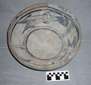
The Rio Grande white wares comprise multiple pottery traditions of the prehistoric Puebloan peoples of New Mexico. About AD 750, the beginning of the Pueblo I Era, after adhering to a different and widespread regional ceramic tradition for generations, potters of the Rio Grande region of New Mexico began developing distinctly local varieties of black-on-white pottery. This pottery involved the use of black mineral paint or black vegetal paint on a white, off-white, or light gray background. The black-on-white tradition finally died out about AD 1750.
Senecú is a small Mexican village, now on the outskirts of Ciudad Juárez, Chihuahua. It is at an altitude of 1,123 m. and lies within the Chihuahuan Desert ecosystem.
Polvadera is an unincorporated community and census-designated place in Socorro County in central New Mexico, United States. It is located on the west bank of the Rio Grande, near the mouth of the Rio Salado, and on the western spur of El Camino Real de Tierra Adentro.
San Acacia is a small unincorporated community and census-designated place in Socorro County, New Mexico, United States. It was once a prosperous railway town, but is now largely deserted. There is a nearby diversion dam on the Rio Grande, important in irrigation.

The Middle Rio Grande Project manages water in the Albuquerque Basin of New Mexico, United States. It includes major upgrades and extensions to the irrigation facilities built by the Middle Rio Grande Conservancy District and modifications to the channel of the Rio Grande to control sedimentation and flooding. The bulk of the work was done by the United States Bureau of Reclamation and the United States Army Corps of Engineers in the 1950s, but construction continued into the 1970s and maintenance is ongoing. The project is complementary to the San Juan–Chama Project, which transfers water from the San Juan River in the Colorado River Basin to the Rio Grande. Although distribution of water from the two projects is handled through separate allotments and contracts, there is some sharing of facilities including the river itself. The ecological impact on the river and the riparian zone was the subject of extended litigation after a group of environmentalists filed Rio Grande Silvery Minnow v. Bureau of Reclamation in 1999.

Tome is an unincorporated village and census-designated place in Valencia County, New Mexico, United States. It is located in the Rio Grande valley near the foot of Tome Hill, a notable Catholic pilgrimage site. The village lies along New Mexico State Road 47 and is neighbored by Valencia to the north and Adelino to the south. It is the location of the Valencia Campus of the University of New Mexico. Tome has a post office with ZIP code 87060. The population was 1,867 as of the 2010 census.
Contadero is a ghost town along the east bank of the Rio Grande in Socorro County, New Mexico, United States.
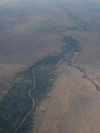
The Rio Grande Valley is the river valley carved out by the Rio Grande as it flows through the American Southwest and northeastern Mexico, forming a part of the border region. In the US state of New Mexico, the river flows mostly north to south, and forms a valley near Cochiti Pueblo to the state line near El Paso, Texas along the floors of the large sedimentary basins of the Rio Grande Rift, and includes the narrow sections between the basins. It has been historically settled first by the Pueblo peoples, the Spanish, the Mexicans, and finally Anglo-Americans. As the largest river in the state, some of its most populous cities are located wholly or partially in the valley, including Albuquerque, New Mexico's largest city.


