Lunde Formation

Last updated
Lunde Formation
Stratigraphic range: Rhaetian
~203–202  Ma
O
S
D
C
P
T
J
K
Pg
N
Oseberg Field Center.jpg
The formation was drilled by a similar platform to this at Oseberg
Type Formation
Unit of Keuper/Hegre Group
Sub-unitsUpper and Lower Members
Underlies Statfjord Formation
Overlies Muschelkalk formations
AreaBetween Shetland Platform and Norwegian mainland
Lithology
Primary Mudstone
Other Paleosols
Location
Coordinates 61°30′N2°12′E / 61.5°N 2.2°E / 61.5; 2.2
Approximate paleocoordinates 46°12′N1°18′W / 46.2°N 1.3°W / 46.2; -1.3
Region Snorre Field, North Sea
CountryFlag of Norway.svg  Norway
Flag of Scotland.svg  Scotland
ExtentNorthern Viking Graben
Type section
Named for Lunde
North Sea relief location map.jpg
Pink ff0080 pog.svg
Lunde Formation (North Sea)

The Lunde Formation is a geologic formation in Norway. The formation was known to preserve fossils of Plateosaurus sp. in the Norwegian offshore (Snorre Field well 34/4-9S), dating back to the Rhaetian period. [1] The formation comprises dry floodplain; paleosol/pedogenic, concretionary, brown, red, calcareous mudstones. [2]

Contents

Description

The Lunde Formation occurs in the northern part of a Late Triassic continental basin that covered most of the present North Sea area. Several thousands of meters of fluvial sediments were deposited in this basin during a thermal subsidence phase following Late Permian to Early Triassic rifting. [1]

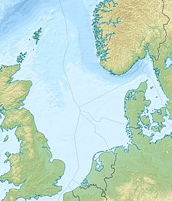
With an approximate width of 400 kilometres (250 mi) between present mainland Norway and the Shetland Platform, the continental post-rift basin contains the Teist, Lomvi and Lunde Formations, and lasted throughout the Triassic until the final depositional stages of the overlying latest Triassic to Early Jurassic Statfjord Formation, when the whole area was flooded during a marine transgression from the north and south in late Sinemurian to early Pliensbachian times. [1]

The climate during deposition of the Lunde Formation was semiarid and highly seasonal, typical for the contemporary palaeogeographic position at 40-50 degrees North paleolatitude. [1]

The basin was linked to a marine borealic seaway, probably located some tens to hundreds of kilometers to the north and to provenance areas composed of Archean gneisses, Caledonian metamorphic rocks and Devonian sandstones. These sources located on the Shetland Platform and in the southwestern area of Norway and deposited into a vast alluvial plain in the Triassic of what is now the North Sea. [1]

The bone slice of Plateosaurus was discovered during the description of a core retrieved in February 1997 from well 34/4-9S in the north-western part of the Snorre Field. It occurs in a reddish-brown, mudstone interval referred to as the upper member of the Lunde Formation. [3]

The mudstone is composed of dominantly compound and cumulative paleosols that formed in distal to fluvial channels in a floodplain forming the uppermost part of the upper member of the Lunde Formation. The paleosols are characterized by carbonate nodules, pedogenic mud aggregates and slickensides, mottling, root traces and mud cracks. The paleosol type is similar to modern vertisols forming in semi-arid areas with seasonal precipitation, commonly with dry periods lasting 4–8 months. The presence of root traces suggests that the floodplain was covered with small trees and bushes, vegetation suitable for herbivorous animals living on the alluvial plain. [3]

Beds containing the bone specimen belong to the younger of two palynomorph assemblages containing the spore Kreuselisporites reissingeri thought to indicate an early Rhaetian rather than a Norian age, corresponding approximately to an age of 203-202 Ma according to the time scale of Gradstein et al. (2005). [3]

See also

Related Research Articles

<span class="mw-page-title-main">Chinle Formation</span> Geological formation in the western US

The Chinle Formation is an Upper Triassic continental geological formation of fluvial, lacustrine, and palustrine to eolian deposits spread across the U.S. states of Nevada, Utah, northern Arizona, western New Mexico, and western Colorado. In New Mexico, it is often raised to the status of a geological group, the Chinle Group. Some authors have controversially considered the Chinle to be synonymous to the Dockum Group of eastern Colorado and New Mexico, western Texas, the Oklahoma panhandle, and southwestern Kansas. The Chinle Formation is part of the Colorado Plateau, Basin and Range, and the southern section of the Interior Plains. A probable separate depositional basin within the Chinle is found in northwestern Colorado and northeastern Utah. The southern portion of the Chinle reaches a maximum thickness of a little over 520 meters (1,710 ft). Typically, the Chinle rests unconformably on the Moenkopi Formation.

<span class="mw-page-title-main">Beaufort Group</span> Third of the main subdivisions of the Karoo Supergroup in South Africa

The Beaufort Group is the third of the main subdivisions of the Karoo Supergroup in South Africa. It is composed of a lower Adelaide Subgroup and an upper Tarkastad Subgroup. It follows conformably after the Ecca Group and unconformably underlies the Stormberg Group. Based on stratigraphic position, lithostratigraphic and biostratigraphic correlations, palynological analyses, and other means of geological dating, the Beaufort Group rocks are considered to range between Middle Permian (Wordian) to Early Triassic (Anisian) in age.

The Newark Supergroup, also known as the Newark Group, is an assemblage of Upper Triassic and Lower Jurassic sedimentary and volcanic rocks which outcrop intermittently along the east coast of North America. They were deposited in a series of Triassic basins, the Eastern North American rift basins, approximately 220–190 million years ago. The basins are characterized as aborted rifts, with half-graben geometry, developing parallel to the main rift of the Atlantic Ocean which formed as North America began to separate from Africa. Exposures of the Newark Supergroup extend from South Carolina north to Nova Scotia. Related basins are also found underwater in the Bay of Fundy. The group is named for the city of Newark, New Jersey.

<span class="mw-page-title-main">Ischigualasto Formation</span> Geological formation in Argentina

The Ischigualasto Formation is a Late Triassic geological formation in the Ischigualasto-Villa Unión Basin of southwestern La Rioja Province and northeastern San Juan Province in northwestern Argentina. The formation dates to the late Carnian and early Norian stages of the Late Triassic, according to radiometric dating of ash beds.

The Lias Group or Lias is a lithostratigraphic unit found in a large area of western Europe, including the British Isles, the North Sea, the Low Countries and the north of Germany. It consists of marine limestones, shales, marls and clays.

Sangusaurus is an extinct genus of large dicynodont synapsid with two recognized species: S. edentatus and S. parringtonii. Sangusaurus is named after the Sangu stream in eastern Zambia near to where it was first discovered + ‘saur’ which is the Greek root for lizard. Sangusaurus fossils have been recovered from the upper parts of the Ntawere Formation in Zambia and of the Lifua Member of the Manda Beds in Tanzania. The earliest study considered Sangusaurus a kannemeyeriid dicynodont, but more recent phylogenetic analyses place Sangusaurus within the stahleckeriid clade of Dicynodontia. Until recently, little work had been done to describe Sangusaurus, likely due to the fact that only four incomplete fossil specimens have been discovered.

The Porcupine Hills Formation is a stratigraphic unit of middle to late Paleocene age in the Western Canada Sedimentary Basin. It takes its name from the Porcupine Hills of southwestern Alberta, and was first described in outcrop by George Mercer Dawson in 1883.

The Dawson Arkose is a geologic formation in the Denver Basin that underlies the Denver area in Colorado. It is characterized by alternating beds of arkosic sandstone and mudstone. The Dawson Arkose contains plant remains and other nonmarine fossils, and hosts aquifers that are important sources of water for the area.

<span class="mw-page-title-main">Himalayan foreland basin</span> Active collisional foreland basin in South Asia

The Himalayan foreland basin is an active collisional foreland basin system in South Asia. Uplift and loading of the Eurasian Plate on to the Indian Plate resulted in the flexure (bending) of the Indian Plate, and the creation of a depression adjacent to the Himalayan mountain belt. This depression was filled with sediment eroded from the Himalaya, that lithified and produced a sedimentary basin ~3 to >7 km deep. The foreland basin spans approximately 2,000 kilometres (1,200 mi) in length and 450 kilometres (280 mi) in width. From west to east the foreland basin stretches across five countries: Pakistan, India, Nepal, Bangladesh, and Bhutan.

<span class="mw-page-title-main">Mata Amarilla Formation</span>

The Mata Amarilla Formation is a fossiliferous formation of the Austral Basin in southern Patagonia, Argentina. The formation consists of sediments deposited during the Middle Cenomanian, dated to 96.94 to 95.52 Ma. The middle section of the formation was previously considered to be the Pari Aike Formation.

<span class="mw-page-title-main">Taranaki Basin</span> Onshore-offshore Cretaceous rift basin on the West Coast of New Zealand

The Taranaki Basin is an onshore-offshore Cretaceous rift basin on the West Coast of New Zealand. Development of rifting was the result of extensional stresses during the breakup of Gondwanaland. The basin later underwent fore-arc and intra-arc basin development, due to the subduction of the Pacific Plate under the Australian Plate at the Hikurangi Subduction System. The basin covers approximately 100,000 km2 of which the majority is offshore. The basin contains mostly marine sediment, with significant terrestrial sediment from the Late Cretaceous to the Eocene. The majority of New Zealand's oil and gas production occurs within the basin, with over 600 wells and approximately 20 oil and gas fields being drilled.

The Worcester Basin or Worcester Graben is a sedimentary basin in central England, filled with mainly Permian and Triassic rocks. It trends roughly north-south and lies between the East Malverns Fault in the west and the Inkberrow Fault in the east. It forms part of a series of Permo-Triassic basins that stretch north-south across England, including the Cheshire Basin, Stafford Basin and the East Irish Sea Basin. These basins resulted from a regional rifting event that affected parts of North-West Europe, eastern North America and East Greenland.

<span class="mw-page-title-main">Huab Formation</span> Geologic formation in Africa

The Huab Formation is an Early Permian geologic formation correlated with the Ecca Group and designated "Ecca" Group, because it does not belong to the Karoo, in the southwestern Kunene Region and northern Erongo Region of northwestern Namibia. The Huab Formation represents the oldest sedimentary unit of the Huab Basin, overlying the basement. The oil shales within the formation were deposited in a shallow lacustrine environment, and the formation marks the transition from terrestrial deposits under glacial climatic circumstances towards a warmer fluvial and marine deltaic environment.

<span class="mw-page-title-main">Omingonde Formation</span>

The Omingonde Formation is an Early to Middle Triassic geologic formation, part of the Karoo Supergroup, in the western Otjozondjupa Region and northeastern Erongo Region of north-central Namibia. The formation has a maximum thickness of about 600 metres (2,000 ft) and comprises sandstones, shales, siltstones and conglomerates, was deposited in a fluvial environment, alternating between a meandering and braided river setting.

The geology of Denmark includes 12 kilometers of unmetamorphosed sediments lying atop the Precambrian Fennoscandian Shield, the Norwegian-Scottish Caledonides and buried North German-Polish Caledonides. The stable Fennoscandian Shield formed from 1.45 billion years ago to 850 million years ago in the Proterozoic. The Fennoscandian Border Zone is a large fault, bounding the deep basement rock of the Danish Basin—a trough between the Border Zone and the Ringkobing-Fyn High. The Sorgenfrei-Tornquist Zone is a fault-bounded area displaying Cretaceous-Cenozoic inversion.

<span class="mw-page-title-main">Katberg Formation</span> Geological formation in the Beaufort Group of the Karoo Supergroup in South Africa

The Katberg Formation is a geological formation that is found in the Beaufort Group, a major geological group that forms part of the greater Karoo Supergroup in South Africa. The Katberg Formation is the lowermost geological formation of the Tarkastad Subgroup which contains the Lower to Middle Triassic-aged rocks of the Beaufort Group. Outcrops and exposures of the Katberg Formation are found east of 24 degrees on wards and north of Graaff-Reniet, Nieu Bethesda, Cradock, Fort Beaufort, Queensdown, and East London in the south, and ranges as far north as Harrismith in deposits that form a ring around the Drakensberg mountain ranges.

<span class="mw-page-title-main">Teekloof Formation</span> Late Permian geological formation that forms part of the Beaufort Group of South Africa

The Teekloof Formation is a geological formation that forms part of the Beaufort Group, one of the five geological groups that comprises the Karoo Supergroup in South Africa. The Teekloof Formation is the uppermost formation of Adelaide Subgroup deposits West of 24ºE and contains Middle to Late Permian-aged deposits and four biozones of the Beaufort Group. It overlies the Abrahamskraal Formation. The Teekloof Formation does not underlie other units other than the younger Karoo dolerites and sills that relate to the emplacement of the Early Jurassic Drakensberg Group to the east. Outcrops and exposures of the Teekloof Formation range from Sutherland through the mountain escarpments between Fraserburg and Beaufort West. The northernmost localities of the Teekloof Formation are found by Loxton, Victoria West and Richmond.

The Borucice Formation, also known in older literature as the Borucice Series, is a Jurassic geologic formation that extends to nearly whole of Poland. This formation represents the last sequence of the lower Jurassic in Poland, recovering the depositional sequences IX and X, and may even recover lowermost parts of the first Middle Jurassic sequence. It represents mostly a series of alluvial depositional systems with subordinate intervals of deltaic deposits. Dinosaur Tracks are among the fossils that have been recovered from the formation. Most of the sediments of the Polish realm come from deltaic, fluvial and marine deposits. It mainly consists of light whitish-grey, fine grained sandstones interbedded by clay containing plant detritus and minute fragments of coal. It also has dark grey mudstones with marine lamellibranches and an Upper Lias microfauna. Its main equivalents are the Jurensismergel Formation of Germany, upper part of the Rya Formation and the uppermost Sorthat Formation (Bornholm). There are also coeval abandoned informal units in Poland: Upper Lisiec beds, or the Kamień Beds.

A feature of the geology of England, the Stafford Basin extends beneath much of the Midlands county of Staffordshire. It is a depositional basin which was initiated during the Permian period and continued to receive sediment during the Triassic period and probably thereafter. Part of a more extensive set of linked basins, it connects with the Cheshire Basin to the northwest, the Worcester Basin via the Bratch Graben to the south and the Needwood Basin to the east. It is flanked in part to the west by the Coalbrookdale Coalfield and to the east by the South Staffordshire Coalfield. The sedimentary sequence, principally sandstones and mudstones, within the basin is continuous with that of the adjoining basins in the rift complex. Deposition of the Chester Formation for example is ascribed to a river flowing north from the Worcester Basin through the Stafford Basin and on into the Cheshire and East Irish Sea basins during the early Triassic. In contrast the Bridgnorth Sandstone Formation of this area is of aeolian origin, the equivalent of the Collyhurst Sandstone of the Cheshire Basin.

References

  1. 1 2 3 4 5 Hurum et al., 2006, p.117
  2. Snorre Field well 34/4-9S at Fossilworks.org
  3. 1 2 3 Hurum et al., 2006, p.118

Bibliography