This article needs additional citations for verification .(April 2014) |
Lutts, Tennessee | |
|---|---|
| Nickname: Pinhook | |
 Lutts, Tennessee | |
| Coordinates: 35°09′04″N87°56′17″W / 35.15111°N 87.93806°W | |
| Country | United States |
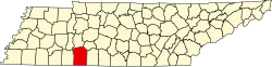
| State | Tennessee |
| County | Wayne |
| Elevation | 581 ft (177 m) |
| Population (2010)Population of the Zip Code for Lutts | |
• Total | 530. [1] |
| Time zone | Central (CST) |
| • Summer (DST) | CDT |
| ZIP code | 38471 |
| Area code | 931 |
Lutts is an unincorporated community in Wayne County, Tennessee, United States. [2] It is also known as "Pinhook."
Contents
- Economy
- History
- Tornado
- Highways
- Churches in or near Lutts
- Nearby cities and communities
- References
- External links
Lutts is served by the Lutts Volunteer Fire Department and Lutts Community Center. The Pinhook School formerly operated in Lutts.