This article has multiple issues. Please help improve it or discuss these issues on the talk page . (Learn how and when to remove these messages)
|
m116 | |||
|---|---|---|---|
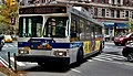
 A 2021 Nova Bus LFS HEV (9670) on the East Harlem-bound M116 at Broadway/106th Street | |||
| Overview | |||
| System | MTA Regional Bus Operations | ||
| Operator | Manhattan and Bronx Surface Transit Operating Authority | ||
| Garage | Manhattanville Depot | ||
| Vehicle | Nova Bus LFS HEV New Flyer Xcelsior XDE40 Orion VII NG HEV | ||
| Began service | April 1, 1936 | ||
| Route | |||
| Locale | Manhattan, New York, U.S. | ||
| Communities served | Upper West Side, Harlem, East Harlem | ||
| Start | Upper West Side - 106th Street & Broadway | ||
| Via | 116th Street | ||
| End | East Harlem – 120th Street & Pleasant Avenue | ||
| Length | 2.9 miles (4.7 km) | ||
| Service | |||
| Operates | All times except late nights | ||
| Annual patronage | 541,474 (2024) [1] | ||
| Transfers | Yes | ||
| Timetable | M116 | ||
| |||
The 116th Street Line is a public transit line in Manhattan, running mostly along 116th Street. Originally a streetcar line, it is now the M116 bus route operated by MaBSTOA, running between the Upper West Side and East Harlem.