
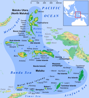
North Maluku is a province of Indonesia. It covers the northern part of the Maluku Islands, bordering the Pacific Ocean to the north, the Halmahera Sea to the east, the Molucca Sea to the west, and the Seram Sea to the south. The provincial capital is Sofifi on the largest island of Halmahera, while the largest city is the island city of Ternate. The population of North Maluku was 1,038,087 in the 2010 census, making it one of the least-populous provinces in Indonesia, but by the 2020 Census the population had risen to 1,278,764.

Morotai Island Regency is a regency of North Maluku province, Indonesia, located on Morotai Island. It covers an area of 2,337.15 km2. The population was 52,860 at the 2010 Census and 74,436 at the 2020 Census.
Halmahera, formerly known as Jilolo, Gilolo, or Jailolo, is the largest island in the Maluku Islands. It is part of the North Maluku province of Indonesia, and Sofifi, the capital of the province, is located on the west coast of the island.

The Molucca Sea is located in the western Pacific Ocean, around the vicinity of Indonesia, specifically bordered by the Indonesian Islands of Celebes (Sulawesi) to the west, Halmahera to the east, and the Sula Islands to the south. The Molucca Sea has a total surface area of 77,000 square miles. The Molucca Sea is rich in coral and has many diving sites due to the deepness of its waters. The deepness of the water explains the reasoning behind dividing the sea into three zones, which functions to transport water from the Pacific Ocean to the shallower seas surrounding it. The deepest hollow in the Molucca Sea is the 15,780-foot (4,810-meter) Batjan basin. This region is known for its periodic experiences of earthquakes, which stems from the sea itself being a micro plate, in which the Molucca Sea is being subducted in two opposite directions: one in the direction of the Eurasian Plate to the west and the other in the direction of the Philippines Sea Plate to the east.

The South Halmahera–West New Guinea (SHWNG) languages are a branch of the Malayo-Polynesian languages, found in the islands and along the shores of the Halmahera Sea in the Indonesian province of North Maluku and of Cenderawasih Bay in the provinces of Papua and West Papua. There are 38 languages.

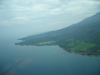
Tobelo is a town and a district on the eastern Indonesian island of Halmahera. It is the capital of the regency (kabupaten) of North Halmahera, part of the province of North Maluku. The city was formalised as the capital of North Halmahera in the district elections held in 2004. It has a population of approximately 33,700. A palm tree lined coastal road connects Tobelo to Galela. The town is predominantly Christian and a Protestant Church has existed in Tobelo since at least 1924.
The South Halmahera languages are the branch of Austronesian languages found along the southeast coast of the island of Halmahera in the Indonesian province of North Maluku. Irarutu is spoken in the east of the Bomberai Peninsula in West Papua province.

North Halmahera Regency is a regency of North Maluku Province, Indonesia. It was declared a Regency on 31 May 2003. The capital town of the regency lies at the port of Tobelo. The Regency, which has been considerably reduced by the separation of Tidore and of Morotai Island, now covers an area of 3,896.9 square kilometres (1,504.6 sq mi) and had a population of 161,847 people at the 2010 Census and 179,783 at the 2015 Intermediate Census. The latest official estimate is 199,935. The principal settlements are Tobelo, Kao and Galela. The area is noted for its white beaches and coral reefs.
West Halmahera Regency is a regency in North Maluku Province, Indonesia. It covers an area of 2,227.56 km2, and as of the 2010 Census it had a population of 100,424 people. The latest official estimate is 114,956. The capital lies at Jailolo.

South Halmahera Regency is a regency of North Maluku Province, Indonesia. It lies partly on Halmahera Island and partly on smaller islands to the west and south of Halmahera. It covers a land area of 8,779.320 km2, and at the 2010 Census it had a population of 198,911 people, while the 2020 Census showed that this had risen to 248,395. The capital lies at the town of Labuha on Bacan Island.
East Halmahera Regency is a regency of Halmahera in North Maluku Province, Indonesia. It covers a land area of 6,538.10 km2, and it had a population of 72,880 at the 2010 Census and 91,707 at the 2020 Census. The capital lies at Buli in Maba District, a port on the Gulf of Buli.
Loloda is a North Halmahera language of Indonesia.
Buli Airport is an airport in Buli, Pekaulang, Maba, East Halmahera Regency, North Maluku, Indonesia.
Maba is a South Halmahera language of southern Halmahera, Indonesia.
Kayoa, or in the native language Pulau Urimatiti, is an island, one of the Maluku Islands. It is located in South Halmahera Regency, part of North Maluku Province of Indonesia.
Suanggi is a malevolent spirit in the folklore of the Maluku Islands, Indonesia.

The Togutil people are an indigenous group with a semi-nomadic lifestyle living in the jungles of Totodoku, Tukur-Tukur, Lolobata, Kobekulo and Buli, North Maluku in the Aketajawe-Lolobata National Park, North Halmahera Regency, North Maluku, Indonesia.
Pekaulang is an administrative division of the Maba district in East Halmahera Regency, North Maluku, Indonesia.


