
The Eyre Peninsula is a triangular peninsula in South Australia. It is bounded on the east by Spencer Gulf, the west by the Great Australian Bight, and the north by the Gawler Ranges.

Capella is a small town and locality in the Central Highlands Region, Queensland, Australia. In the 2016 census, Capella had a population of 1,010 people.

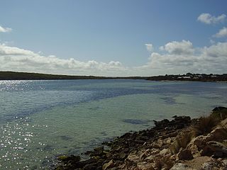
The District Council of Cleve is a local government area on the eastern Eyre Peninsula in South Australia. The district is mostly agricultural in nature, but also encompasses the popular coastal tourist town of Arno Bay.

Buckleboo is a locality in the Australian state of South Australia on the Eyre Peninsula located about 313 kilometres (194 mi) northwest of the state capital of Adelaide and about 31 kilometres (19 mi) northwest of the municipal seat of Kimba.
Coffin Bay, originally Coffin's Bay, is a town at the southern extremity of the Eyre Peninsula, a wheat growing area of South Australia. At the 2016 census, Coffin Bay had a population of 611.
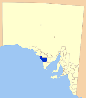
The District Council of Elliston is a local government area covering around 6500 km2 on the Western Eyre Peninsula in South Australia. Established in 1888, the district has a diverse economy, with agriculture, commercial fishing and tourism making up the majority of the local economy.
This article describes the railway stations on the Eyre Peninsula of South Australia that were located on the lines of the Port Lincoln Division of the former South Australian Railways (SAR). Few of them were staffed. All stations were closed in 1968 when the SAR withdrew all passenger services.

Yaninee is a small town situated on the Eyre Highway in central Eyre Peninsula, South Australia, 21 kilometres (13 mi) west of Wudinna. At the 2006 census, Yaninee and the surrounding area had a population of 120.
Kielpa is a town and locality on Eyre Peninsula in South Australia. It is midway between Rudall and Darke Peak on the Eyre Peninsula Railway.
Rudall is a town and locality in South Australia. At the 2016 census, Rudall had a population of 90. It is named for the cadastral Hundred of Rudall, which was named after politician Samuel Rudall.

Warramboo (wɔrˑræmˑbʉː) is a locality on Eyre Peninsula in the Australian state of South Australia 334 kilometres (208 mi) north-west of the state capital of Adelaide and about 26 kilometres (16 mi) south-east of the municipal seat of Wudinna. It is 189 kilometres (117 mi) north of Port Lincoln on the Tod Highway and is the north-western terminus of the wheat haulage lines radiating from Port Lincoln on the Eyre Peninsula Railway. The railway line was built from 1907–1915 to develop the cereal industry. The grain silos are a distinctive local landmark of the town.
Pinkawillinie is a locality in the north of Eyre Peninsula in South Australia. It is a rural grain and grazing area in marginal country near Goyder's Line. It draws its name from the cadastral Hundred bearing the same name which is mostly included in the modern bounded locality, however the locality includes several other Hundreds and the Pinkawillinie Conservation Park.
Murdinga is a locality in South Australia located on the Eyre Peninsula about 297 kilometres (185 mi) west of the state capital of Adelaide. The name reportedly stems from an Aboriginal word for "cold".
Ucolta is a locality in the Mid North region of South Australia. It is named for a railway station on the Broken Hill-Port Pirie railway line. Trains no longer stop at Ucolta. It is also where the Barrier Highway first meets the railway line, and the Wilmington–Ucolta Road which connects across the northern side of the Mid North, providing the shortest road route from Western Australia and Eyre Peninsula via Port Augusta to Broken Hill and New South Wales.
Whites Flat is a rural locality in the Eyre and Western region of South Australia, situated within the District Council of Lower Eyre Peninsula. The boundaries for the locality were formally established in October 2003 for the long established local name; this had originally been named after pastoralist Samuel White.
County of Manchester is a cadastral unit located in the Australian state of South Australia that covers land both located in the north-east of Eyre Peninsula and to the peninsula's north. It was proclaimed in 1891 and named after George Montagu, 6th Duke of Manchester who was the father-in-law of the Rt Hon. Earl of Kintore GCMG, the Governor of South Australia at the time.

Heggaton Conservation Park is a protected area in the Australian state of South Australia, located on the Eyre Peninsula in the gazetted locality of Mangalo about 28 kilometres (17 mi) south-east of Kimba.

County of Buxton is a cadastral unit located in the Australian state of South Australia that covers land located in the centre of Eyre Peninsula. It was proclaimed in 1896 and named after Thomas Buxton who was the Governor of South Australia from 29 October 1895 to 29 March 1899. It has been divided into thirteen sub-divisions known as hundreds, with the most recent being created in 1928.

The County of Jervois is a cadastral unit in the Australian state of South Australia that covers land on the east coast of the Eyre Peninsula. It was proclaimed on 24 January 1878 and named after William Jervois, the Governor of South Australia from October 1877 to January 1883.
Waddikee is a locality on Eyre Peninsula in South Australia. It is on the Eyre Peninsula Railway southwest of Kimba.
