
Konstantinovsky District is an administrative and municipal district (raion), one of the forty-three in Rostov Oblast, Russia. It is located in the center of the oblast. The area of the district is 2,200 square kilometers (850 sq mi). Its administrative center is the town of Konstantinovsk. Population: 33,159 ; 36,595 (2002 Census); 36,741 (1989 Census). The population of Konstantinovsk accounts for 54.1% of the district's total population.
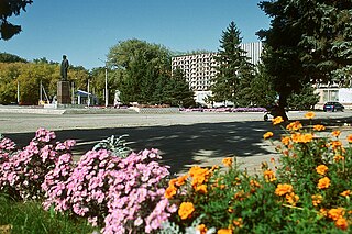
Zernograd is a town and the administrative center of Zernogradsky District in Rostov Oblast, Russia, located 71 kilometers (44 mi) southeast of Rostov-on-Don, the administrative center of the oblast. Population: 26,842 (2010 Census); 28,840 (2002 Census); 26,097 (1989 Census).

Bokovsky District is an administrative and municipal district (raion), one of the forty-three in Rostov Oblast, Russia. It is located in the north of the oblast. The area of the district is 1,927 square kilometers (744 sq mi). Its administrative center is the rural locality of Bokovskaya. Population: 15,085 ; 16,111 (2002 Census); 19,212 (1989 Census). The population of Bokovskaya accounts for 32.0% of the district's total population.
Chertkovsky District is an administrative and municipal district (raion), one of the forty-three in Rostov Oblast, Russia. It is located in the northwest of the oblast. The area of the district is 2,766 square kilometers (1,068 sq mi). Its administrative center is the rural locality of Chertkovo. Population: 36,680 ; 39,974 (2002 Census); 40,355 (1989 Census). The population of Chertkovo accounts for 29.5% of the district's total population.

Dubovsky District is an administrative and municipal district (raion), one of the forty-three in Rostov Oblast, Russia. It is located in the east of the oblast. The area of the district is 3,993.2 square kilometers (1,541.8 sq mi). Its administrative center is the rural locality of Dubovskoye. As of the 2010 Census, the total population of the district was 22,983, with the population of Dubovskoye accounting for 37.2% of that number.
Kasharsky District is an administrative and municipal district (raion), one of the forty-three in Rostov Oblast, Russia. It is located in the north of the oblast. The area of the district is 3,112 square kilometers (1,202 sq mi). Its administrative center is the rural locality of Kashary. Population: 25,355 ; 27,424 (2002 Census); 29,712 (1989 Census). The population of Kashary accounts for 25.8% of the district's total population.

Kuybyshevsky District is an administrative and municipal district (raion), one of the forty-three in Rostov Oblast, Russia. It is located in the west of the oblast. The area of the district is 871 square kilometers (336 sq mi). Its administrative center is the rural locality of Kuybyshevo. Population: 14,800 ; 15,237 (2002 Census); 14,061 (1989 Census). The population of Kuybyshevo accounts for 41.5% of the district's total population.
Peschanokopsky District is an administrative and municipal district (raion), one of the forty-three in Rostov Oblast, Russia. It is located in the south of the oblast. The area of the district is 1,885 square kilometers (728 sq mi). Its administrative center is the rural locality of Peschanokopskoye. Population: 31,619 ; 34,171 (2002 Census); 34,367 (1989 Census). The population of Peschanokopskoye accounts for 33.5% of the district's total population.

Proletarsky District is an administrative and municipal district (raion), one of the forty-three in Rostov Oblast, Russia. It is located in the south of the oblast. The area of the district is 2,740 square kilometers (1,060 sq mi). Its administrative center is the town of Proletarsk. Population: 36,510 ; 36,297 (2002 Census); 36,346 (1989 Census). The population of Proletarsk accounts for 55.5% of the district's total population.

Remontnensky District is an administrative and municipal district (raion), one of the forty-three in Rostov Oblast, Russia. It is located in the southeast of the oblast. The area of the district is 3,779 square kilometers (1,459 sq mi). Its administrative center is the rural locality of Remontnoye. Population: 19,152 ; 21,497 (2002 Census); 23,202 (1989 Census). The population of Remontnoye accounts for 37.6% of the district's total population.
Rodionovo-Nesvetaysky District is an administrative and municipal district (raion), one of the forty-three in Rostov Oblast, Russia. It is located in the west of the oblast. The area of the district is 1,547 square kilometers (597 sq mi). Its administrative center is the rural locality of Rodionovo-Nesvetayskaya. Population: 23,632 ; 23,391 (2002 Census); 21,665 (1989 Census). The population of Rodionovo-Nesvetayskaya accounts for 27.0% of the district's total population.
Salsky District is an administrative and municipal district (raion), one of the forty-three in Rostov Oblast, Russia. It is located in the south of the oblast. The area of the district is 3,499 square kilometers (1,351 sq mi). Its administrative center is the town of Salsk. Population: 107,795 ; 49,343 (2002 Census); 45,908 (1989 Census). The population of Salsk accounts for 56.9% of the district's total population.

Semikarakorsky District is an administrative and municipal district (raion), one of the forty-three in Rostov Oblast, Russia. It is located in the center of the oblast. The area of the district is 1,402 square kilometers (541 sq mi). Its administrative center is the town of Semikarakorsk. Population: 52,833 ; 54,125 (2002 Census); 52,222 (1989 Census). The population of Semikarakorsk accounts for 45.2% of the district's total population.

Tatsinsky District is an administrative and municipal district (raion), one of the forty-three in Rostov Oblast, Russia. It is located in the center of the oblast. The area of the district is 2,411 square kilometers (931 sq mi). Its administrative center is the rural locality of Tatsinskaya. Population: 38,464 ; 43,251 (2002 Census); 43,306 (1989 Census). The population of Tatsinskaya accounts for 26.0% of the district's total population.

Ust-Donetsky District is an administrative and municipal district (raion), one of the forty-three in Rostov Oblast, Russia. It is located in the center of the oblast. The area of the district is 1,150 square kilometers (440 sq mi). Its administrative center is the urban locality of Ust-Donetsky. Population: 33,647 ; 32,479 (2002 Census); 30,374 (1989 Census). The population of the administrative center accounts for 35.1% of the district's total population.

Verkhnedonskoy District is an administrative and municipal district (raion), one of the forty-three in Rostov Oblast, Russia. It is located in the north of the oblast. The area of the district is 2,675 square kilometers (1,033 sq mi). Its administrative center is the rural locality of Kazanskaya. Population: 20,441 ; 23,327 (2002 Census); 26,575 (1989 Census). The population of Kazanskaya accounts for 23.1% of the district's total population.

Vesyolovsky District is an administrative and municipal district (raion), one of the forty-three in Rostov Oblast, Russia. It is located in the southern central part of the oblast. The area of the district is 1,355 square kilometers (523 sq mi). Its administrative center is the rural locality of Vesyoly. Population: 26,165 ; 26,564 (2002 Census); 23,016 (1989 Census). The population of Vesyoly accounts for 35.1% of the district's total population.
Yegorlyksky District is an administrative and municipal district (raion), one of the forty-three in Rostov Oblast, Russia. It is located in the south of the oblast. The area of the district is 1,460 square kilometers (560 sq mi). Its administrative center is the rural locality of Yegorlykskaya. Population: 35,733 ; 36,996 (2002 Census); 33,378 (1989 Census). The population of Yegorlykskaya accounts for 49.4% of the district's total population.

Zernogradsky District is an administrative and municipal district (raion), one of the forty-three in Rostov Oblast, Russia. It is located in the south of the oblast. The area of the district is 2,663 square kilometers (1,028 sq mi). Its administrative center is the town of Zernograd. Population: 58,757 ; 66,481 (2002 Census); 61,140 (1989 Census). The population of Zernograd accounts for 45.7% of the district's total population.

Zimovnikovsky District is an administrative and municipal district (raion), one of the forty-three in Rostov Oblast, Russia. It is located in the southeast of the oblast. The area of the district is 5,228 square kilometers (2,019 sq mi). Its administrative center is the rural locality of Zimovniki. Population: 37,092 ; 38,190 (2002 Census); 38,854 (1989 Census). The population of Zimovniki accounts for 48.7% of the district's total population.


