Konstantinovsky District is an administrative and municipal district (raion), one of the forty-three in Rostov Oblast, Russia. It is located in the center of the oblast. The area of the district is 2,200 square kilometers (850 sq mi). Its administrative center is the town of Konstantinovsk. Population: 33,159 ; 36,595 (2002 Census); 36,741 (1989 Census). The population of Konstantinovsk accounts for 54.1% of the district's total population.

Krasny Sulin is a town and the administrative center of Krasnosulinsky District in Rostov Oblast, Russia, located in the Donets Basin region. Population: 40,866 (2010 Census); 44,187 (2002 Census); 43,133 (1989 Census).

Azovsky District is an administrative and municipal district (raion), one of the forty-three in Rostov Oblast, Russia. It is located in the southwest of the oblast. The area of the district is 2,862 square kilometers (1,105 sq mi). Its administrative center is the town of Azov. Population: 93,579 ; 92,568 (2002 Census); 83,393 (1989 Census).

Bokovsky District is an administrative and municipal district (raion), one of the forty-three in Rostov Oblast, Russia. It is located in the north of the oblast. The area of the district is 1,927 square kilometers (744 sq mi). Its administrative center is the rural locality of Bokovskaya. Population: 15,085 ; 16,111 (2002 Census); 19,212 (1989 Census). The population of Bokovskaya accounts for 32.0% of the district's total population.

Kagalnitsky District is an administrative and municipal district (raion), one of the forty-three in Rostov Oblast, Russia. It is located in the southwest of the oblast. The area of the district is 1,370 square kilometers (530 sq mi). Its administrative center is the rural locality of Kagalnitskaya. Population: 30,489 ; 31,189 (2002 Census); 27,901 (1989 Census). The population of Kagalnitskaya accounts for 22.4% of the district's total population.

Kamensky District is an administrative and municipal district (raion), one of the forty-three in Rostov Oblast, Russia. It is located in the west of the oblast. The area of the district is 2,570 square kilometers (990 sq mi). Its administrative center is the urban locality of Gluboky. Population: 47,696 ; 51,757 (2002 Census); 53,291 (1989 Census). The population of Gluboky accounts for 20.7% of the district's total population.
Kasharsky District is an administrative and municipal district (raion), one of the forty-three in Rostov Oblast, Russia. It is located in the north of the oblast. The area of the district is 3,112 square kilometers (1,202 sq mi). Its administrative center is the rural locality of Kashary. Population: 25,355 ; 27,424 (2002 Census); 29,712 (1989 Census). The population of Kashary accounts for 25.8% of the district's total population.

Kuybyshevsky District is an administrative and municipal district (raion), one of the forty-three in Rostov Oblast, Russia. It is located in the west of the oblast. The area of the district is 871 square kilometers (336 sq mi). Its administrative center is the rural locality of Kuybyshevo. Population: 14,800 ; 15,237 (2002 Census); 14,061 (1989 Census). The population of Kuybyshevo accounts for 41.5% of the district's total population.

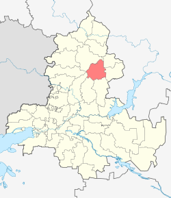
Martynovsky District is an administrative and municipal district (raion), one of the forty-three in Rostov Oblast, Russia. It is located in the center of the oblast. The area of the district is 1,917 square kilometers (740 sq mi). Its administrative center is the rural locality of Bolshaya Martynovka. Population: 36,545 ; 40,499 (2002 Census); 33,684 (1989 Census). The population of Bolshaya Martynovka accounts for 16.9% of the district's total population.

Morozovsky District is an administrative and municipal district (raion), one of the forty-three in Rostov Oblast, Russia. It is located in the east of the oblast. The area of the district is 2,550 square kilometers (980 sq mi). Its administrative center is the town of Morozovsk. Population: 42,404 ; 46,395 (2002 Census); 43,574 (1989 Census). The population of Morozovsk accounts for 65.2% of the district's total population.

Neklinovsky District is an administrative and municipal district (raion), one of the forty-three in Rostov Oblast, Russia. It is located in the west of the oblast, immediately adjacent to the border with Ukraine's Donetsk Oblast. It surrounds the city of Taganrog on that city's landward side. The area of the district is 2,148 square kilometers (829 sq mi). Its administrative center is the rural locality of Pokrovskoye. Population: 84,915 ; 82,706 (2002 Census); 77,775 (1989 Census). The population of Pokrovskoye accounts for 14.6% of the district's total population.

Orlovsky District is an administrative and municipal district (raion), one of the forty-three in Rostov Oblast, Russia. It is located in the southeast of the oblast. The area of the district is 3,300 square kilometers (1,300 sq mi). Its administrative center is the rural locality of Orlovsky. Population: 40,894 ; 41,768 (2002 Census); 39,386 (1989 Census). The population of the administrative center accounts for 48.9% of the district's total population.
Peschanokopsky District is an administrative and municipal district (raion), one of the forty-three in Rostov Oblast, Russia. It is located in the south of the oblast. The area of the district is 1,885 square kilometers (728 sq mi). Its administrative center is the rural locality of Peschanokopskoye. Population: 31,619 ; 34,171 (2002 Census); 34,367 (1989 Census). The population of Peschanokopskoye accounts for 33.5% of the district's total population.

Proletarsky District is an administrative and municipal district (raion), one of the forty-three in Rostov Oblast, Russia. It is located in the south of the oblast. The area of the district is 2,740 square kilometers (1,060 sq mi). Its administrative center is the town of Proletarsk. Population: 36,510 ; 36,297 (2002 Census); 36,346 (1989 Census). The population of Proletarsk accounts for 55.5% of the district's total population.
Salsky District is an administrative and municipal district (raion), one of the forty-three in Rostov Oblast, Russia. It is located in the south of the oblast. The area of the district is 3,499 square kilometers (1,351 sq mi). Its administrative center is the town of Salsk. Population: 107,795 ; 49,343 (2002 Census); 45,908 (1989 Census). The population of Salsk accounts for 56.9% of the district's total population.

Vesyolovsky District is an administrative and municipal district (raion), one of the forty-three in Rostov Oblast, Russia. It is located in the southern central part of the oblast. The area of the district is 1,355 square kilometers (523 sq mi). Its administrative center is the rural locality of Vesyoly. Population: 26,165 ; 26,564 (2002 Census); 23,016 (1989 Census). The population of Vesyoly accounts for 35.1% of the district's total population.

Volgodonskoy District is an administrative and municipal district (raion), one of the forty-three in Rostov Oblast, Russia. It is located in the eastern central part of the oblast. The area of the district is 1,479 square kilometers (571 sq mi). Its administrative center is the rural locality of Romanovskaya. Population: 33,779 ; 30,170 (2002 Census); 24,690 (1989 Census). The population of Romanovskaya accounts for 24.4% of the district's total population.
Yegorlyksky District is an administrative and municipal district (raion), one of the forty-three in Rostov Oblast, Russia. It is located in the south of the oblast. The area of the district is 1,460 square kilometers (560 sq mi). Its administrative center is the rural locality of Yegorlykskaya. Population: 35,733 ; 36,996 (2002 Census); 33,378 (1989 Census). The population of Yegorlykskaya accounts for 49.4% of the district's total population.
Zavetinsky District is an administrative and municipal district (raion), one of the forty-three in Rostov Oblast, Russia. It is located in the southeast of the oblast. The area of the district is 3,000 square kilometers (1,200 sq mi). Its administrative center is the rural locality of Zavetnoye. Population: 17,250 ; 18,508 (2002 Census); 18,638 (1989 Census). The population of Zavetnoye accounts for 41.0% of the district's total population.

Zernogradsky District is an administrative and municipal district (raion), one of the forty-three in Rostov Oblast, Russia. It is located in the south of the oblast. The area of the district is 2,663 square kilometers (1,028 sq mi). Its administrative center is the town of Zernograd. Population: 58,757 ; 66,481 (2002 Census); 61,140 (1989 Census). The population of Zernograd accounts for 45.7% of the district's total population.