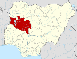
Mashegu

Last updated

Mashegu
LGA and town
Nigeria location map.svg
Red pog.svg
Mashegu
Location in Nigeria
Coordinates: 9°57′N5°13′E / 9.950°N 5.217°E / 9.950; 5.217
CountryFlag of Nigeria.svg  Nigeria
State Niger State
Government
  Local Government Chairman and the Head of the Local Government CouncilShuaibu Haruna Kulho
Area
  Total9,182 km2 (3,545 sq mi)
Population
 (2006 census)
  Total215,022
Time zone UTC+1 (WAT)
3-digit postal code prefix
923
ISO 3166 code NG.NI.MS
Mashegu

Mashegu is a Local Government Area in Niger State, Nigeria. Its headquarters are in the town of Mashegu in the east of the area. Mashegu is bounded by the Niger River in the west and the Kaduna River in the northeast.

Contents

It has an area of 9,182 km2 and a population of 215,022 at the 2006 census.

The postal code of the area is 923. [1]

Climate

The area experiences seasonal temperature variations from 60°F to 97°F, with sporadic excursions below 54°F or above 103°F. [2]

Temperature

With a high of 95°F and a low of 76°F in April, Mashegu has variable average temperatures throughout the year. [2]

Related Research Articles

<span class="mw-page-title-main">Geography of Nigeria</span> Overview of the geography of Nigeria

Nigeria is a country in West Africa. It shares land borders with the Republic of Benin to the west, Chad and Cameroon to the east, and Niger to the north. Its coast lies on the Gulf of Guinea in the south and it borders Lake Chad to the northeast. Notable geographical features in Nigeria include the Adamawa Plateau, Mambilla Plateau, Jos Plateau, Obudu Plateau, the Niger River, Benue River, and Niger Delta.

<span class="mw-page-title-main">Kaduna River</span> River in Nigeria

The Kaduna River is a tributary of the Niger River which flows for 550 kilometres (340 mi) through Nigeria. It got its name from the crocodiles that lived in the river and surrounding area. Kaduna in the native dialect, Hausa, was the word for "crocodiles". It starts in Plateau State on the Jos Plateau 29 kilometres (18 mi) southwest of Jos town, flows through its namesake Kaduna State and through its capital Kaduna, and meets the Niger River in Niger State. Most of its course passes through open savanna woodland, but its lower section has cut several gorges above its entrance into the extensive Niger floodplains. The river is used for fishing and transport of local produce.

<span class="mw-page-title-main">Asaba</span> Capital city of Delta State, Nigeria

Asaba is the capital of Delta State, Nigeria. A rapidly growing city, it is located at the western bank of the Niger River, in the Oshimili South Local Government Area. Asaba had a population of 149,603 as at the 2006 census, and a fast growing metropolitan population of over half a million people.

Idah is a town in Kogi State, Nigeria, on the eastern bank of the Niger River in the middle belt region of Nigeria. It is the headquarter of the Igala Kingdom, and also a Local Government Area with an area of 36 km2. Idah had a population of 79,815 at the 2006 census.

Kontagora is a major town on the south bank of the Kontagora River in north-west Niger State, Nigeria. It is the capital city of the Kontagora Emirate. The former Niger state governor, Alhaji Abubakar Sani Bello hails from Kontagora. On December 15, 1995, the Roman Catholic Apostolic Vicariate of Kontagora was established here. St Michael's Cathedral is the seat of the apostolic vicar.

<span class="mw-page-title-main">Ajaokuta</span> LGA and town in Kogi State, Nigeria

Ajaokuta is a Local Government Area in Kogi State, Nigeria and a town within it on the left bank of the Niger River. The headquarters of the LGA are in the town of Egayin in the south of the area at 6°40′11″N8°48′19″E.

Suleja is a city in Niger State, Nigeria, pop. (2016) local government area, 260,240, just north of Abuja, capital of the Suleja Emirate. It is sometimes confused with the nearby city of Abuja, due to its proximity, and the fact that it was originally called Abuja before the Nigerian government adopted the name from the then Emir Sulayman Bal for its new federal capital in 1976.

Bida is a Local Government Area in Niger State, Nigeria and a city on the A124 highway which occupies most of the area.

Agaie is a Local Government Area in Niger State, Nigeria. Its headquarters are in the town of Agaie on the A124 highway.

Igalamela-Odolu is a Local Government Area in Kogi State, Nigeria. It is bordered by the Niger River in the west and Enugu State in the east. Its headquarters are in the town of Ajaka in the north of the area at7°10′16″N6°49′35″E.

<span class="mw-page-title-main">Gurara, Nigeria</span> LGA in Niger State, Nigeria

Gurara is a Local Government Area in Niger State, Nigeria, adjoining the Federal Capital Territory. Its headquarters are in the town of Gawu. Major inhabitants are the Gwari people. The Gurara Waterfalls is found here.

Lapai is a Local Government Area in Niger State, Nigeria, adjoining the Federal Capital Territory. Its headquarters are in the town of Lapai on the A124 highway in the west of the area at 9°03′00″N6°34′00″E.

Chanchaga is a Local Government Area in Niger State, Nigeria. Its headquarters is in the state capital of Minna which occupies much of the Local Government Area.

Paikoro Local Government is one of the 774 Local Government Areas of Nigeria and one of 25 Local Government areas in Niger-State Nigeria. Paikoro Local Government headquarter is located in Paiko town about 25 km south-east of the state capital Minna.

Wushishi is a Local Government Area in Niger State, Nigeria. Its headquarters is in the town of Wushishi.

Agwara is a Local Government Area in Niger State, Nigeria. Its headquarters are in the town of Agwara.

Rijau is a Local Government Area in Niger State, Nigeria. Its headquarters are in the town of Rijau.

Katcha is a local government area of Niger State, in central Nigeria. Its headquarters are in the town of Katcha. Badeggi is one of the major towns of the local government area, located on the A124 highway in the west of the area at 9°03′00″N6°09′00″E.

Mokwa is a Local Government Area in Niger State, Nigeria. Its headquarters are in the town of Mokwa on the A1 highway in the west of the area.

Machina is a Local Government Area in Yobe State, Nigeria. Its headquarters are in the town of Machina at 13°08′11″N10°02′57″E. It shares a border in the north with The Republic of Niger.

References

  1. "Post Offices- with map of LGA". NIPOST. Archived from the original on 2009-10-07. Retrieved 2009-10-20.
  2. 1 2 "Mashegu Climate, Weather By Month, Average Temperature (Nigeria) - Weather Spark". weatherspark.com. Retrieved 2023-09-10.