Google Maps is a web mapping platform and consumer application offered by Google. It offers satellite imagery, aerial photography, street maps, 360° interactive panoramic views of streets, real-time traffic conditions, and route planning for traveling by foot, car, bike, air and public transportation. As of 2020, Google Maps was being used by over one billion people every month around the world.

Ikoyi is the most affluent neighborhood of Lagos, located in Eti-Osa Local Government Area. It lies to the northeast of Obalende and adjoins Lagos Island to the west, and at the edge of the Lagos Lagoon. Popular with the extreme upper class residents of Nigerian society, Ikoyi is arguably one of the wealthiest communities within Nigeria.

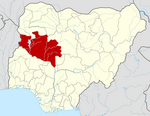
Niger is a state in the North Central region of Nigeria and the largest state in the country. Niger state has three political zones, zone A, B and C. The state's capital is at Minna. Other major cities are Bida, Kontagora and Suleja. It was formed in 1976 when the then North-Western State was divided into Niger State and Sokoto State. It is home to Ibrahim Babangida and Abdulsalami Abubakar, two of Nigeria's former military rulers. The Nupe, Gbagyi, Kamuku, Kambari, Gungawa, Hun-Saare, Hausa and Koro form the majority of numerous indigenous tribes of Niger State.

Kano State is one of the 36 states of Nigeria, located in the northern region of the country. According to the national census done in 2006, Kano State is the most populous state in Nigeria. The recent official estimates taken in 2016 by the National Bureau of Statistics found that Kano State was still the largest state by population in Nigeria. Created in 1967 out of the former Northern Region, Kano State borders with Katsina State to the northwest, Jigawa State to the northeast, Bauchi State to the southeast, and Kaduna State to the southwest. The state's capital and largest city is the city of Kano, the second most populous city in Nigeria after Lagos. The incumbent governor of the state is Abba Kabir Yusuf. He was sworn in on 29 May 2023.
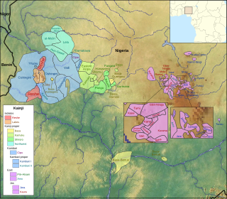
The Kainji languages are a group of about 60 related languages spoken in west-central Nigeria. They form part of the Central Nigerian (Platoid) branch of Benue–Congo.

The Jebba Hydroelectric Power Station, also Jebba Power Station, is a hydroelectric power plant across the Niger River in Nigeria. It has a power generating capacity of 578.4 megawatts, enough to power over 364,000 homes. The plant was commissioned on 13 April 1985, although commercial energy production began in 1983.

The Shiroro Power Station is a hydroelectric power plant of the Kaduna River in Niger State, Nigeria. It has a power generating capacity of 600 megawatts (800,000 hp) enough to power over 404,000 homes
Chikun is a Local Government Area in central Kaduna State, Nigeria. It has an area of about 4,466 km2, and had a population of 372,272 as at the 2006 census. Its headquarters is located in the town of Kujama. The postal code of the area is 2438000.
Shiroro Airstrip or Shiroro Airfield is an airstrip serving the village of Shiroro and the Shiroro Hydroelectric Power Station in the Niger State of Nigeria. The runway is 10 kilometres (6.2 mi) south of the power station, near the shore of the Shiroro reservoir.
The Kamuku languages are a branch of the Kainji languages spoken by the Kamuku people of Niger State, western Nigeria, mostly in Mariga and Rafi LGAs.
The Sir Abubakar Tafawa BalewaBauchi State International Airport is a new airport serving the city of Bauchi, the capital of Bauchi State, Nigeria. It is named after Sir Abubakar Tafawa Balewa, who was Prime Minister of Nigeria from 1957 to 1966. The airport is 22 kilometres (14 mi) northwest of Bauchi.
Bida Airport is an airport serving Bida in Nigeria.
Copperbelt Energy Corporation Plc (CEC) is a Zambian electricity generation, transmission, distribution and supply company with operations in Zambia and Nigeria. The company is listed on the Lusaka Stock Exchange

French shipbuilding firm Ocea has designed and sold fast patrol boat it calls the Ocea FPB 72. As of June 2018 it has delivered FPB 72 vessels to Suriname, Nigeria and the Philippines.
NNS Badagry is an Ocea FPB 72 patrol boat operated by the Nigerian Navy.
NNS Bomadi (P176) is an Ocea FPB 72 patrol boat operated by the Nigerian Navy.
Zungeru Hydroelectric Power Station is a 700 megawatts (940,000 hp) hydroelectric power plant under construction in Niger State, Nigeria. When completed, as expected, it will be the second-largest hydroelectric power station in the country, behind the 760 megawatts (1,020,000 hp) Kainji Hydroelectric Power Station.
Niger East Senatorial District, known as Zone B within Niger State in Nigeria, Covers 9 local governments which include:
- Bosso local government area
- Chanchaga local government area
- Munya local government area
- Paiko local government area
- Rafi local government area
- Shiroro local government area
- Suleja local government area
- Tafa local government area
- Gurara local government area.
Access Bank South Africa, formerly known as Grobank Limited, and Bank of Athens (South Africa) before that, is a commercial bank in South Africa. It is licensed by the Reserve Bank of South Africa, the central bank and national banking regulator. The bank began commercial operations in June 2021, following the acquisition of a retail commercial banking license.
On June 30, 2022, gunmen ambushed Nigerian soldiers responding to a distress call of an attack on a mining village. Forty-eight people died, including thirty-four soldiers, eight policemen, and six civilians. The attack is one of the deadliest ambushes in Nigeria in recent years.