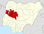
Bida is a Local Government Area in Niger State, Nigeria and a city on the A124 highway which occupies most of the area.

Gboko is a Local Government Area in Benue state, North-central Nigeria. It is headquartered in the town of Gboko.
Agaie is a Local Government Area in Niger State, Nigeria. Its headquarters are in the town of Agaie on the A124 highway.
Langtang South is a Local Government Area in Plateau State, Nigeria. Its headquarters are in the town of Mabudi.
Ahoada East is a Local Government Area of Rivers State, Nigeria, located northwest of Port Harcourt. Its seat is in the city of Ahoada. Towns in Ahoada East include Odiabidi, Edeoha, Ogbo, Abarikpo, Ihugbogo, etc
Maigatari is a border town located in the Sahel along the Niger-Nigeria border. The town is known for its large market founded in 1870 and trading in horses, camels, cattle and other livestock between Niger, Mali, Chad and Cameroon.
Moro is a Local Government Area in Kwara State, Nigeria. It has an area of 3,272 km2 and a population of 108,792 at the 2006 census.
Musawa is a Local Government Area in Katsina State, Nigeria. Its headquarters is in the town of Musawa.

Gurara is a Local Government Area in Niger State, Nigeria, adjoining the Federal Capital Territory. Its headquarters are in the town of Gawu. Major inhabitants are the Gwari people. The Gurara Waterfalls is found here.
Wushishi is a Local Government Area in Niger State, Nigeria. Its headquarters is in the town of Wushishi.
Agwara is a Local Government Area in Niger State, Nigeria. Its headquarters are in the town of Agwara.
Rijau is a Local Government Area in Niger State, Nigeria. Its headquarters are in the town of Rijau.
Gbako is a Local Government Area in Niger State, Nigeria. Its headquarters are in the town of Lemu in the north of the area at9°24′00″N6°02′00″E. The Kaduna River forms its western boundary.
Olorunsogo is a Local Government Area in Oyo State, Nigeria. Its headquarters are in the town of Igbeti.
Zurmi is a Local Government Area in Zamfara State, Nigeria. Its headquarters is in the town of Zurmi at 12°46′00″N6°47′10″E.
Machina is a Local Government Area in Yobe State, Nigeria. Its headquarters are in the town of Machina at 13°08′11″N10°02′57″E. It shares a border in the north with The Republic of Niger.
Jakusko is a Local Government Area in Yobe State, Nigeria. Its headquarters are in the town of Jakusko in the west of the area at 12°22′09″N10°46′23″E.
Yunusari is a Local Government Area in Yobe State, Nigeria. It has its headquarters in the town of Kanamma in the north-east of the area on the Burun Gana River at 13°06′15″N12°04′20″E. It shares a border in the north with The Republic of Niger.
Yusufari is a Local Government Area in Yobe State, Nigeria. Its headquarters are in the town of Yusufari in the south-east of the area at 13°04′06″N11°10′33″E. It shares a border in the north with The Republic of Niger.
Ife South is a Local Government Area in Osun State, Nigeria. Its headquarters are in the town of Ifetedo at 7°11′00″N4°42′00″E.


