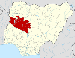
Agaie

Last updated

Agaie
Kin Bokun
Farin Kasa
LGA and town
Nigeria location map.svg
Red pog.svg
Agaie
Location in Nigeria
Coordinates: 9°01′N6°19′E / 9.017°N 6.317°E / 9.017; 6.317
CountryFlag of Nigeria.svg  Nigeria
State Niger State
Government
  Local Government Chairman and the Head of the Local Government CouncilSayuti Ibrahim Halilu
  EmirAlhaji Yusuf Nuhu
Area
  Total1,903 km2 (735 sq mi)
Population
 (2006 census)
  Total132,907
Time zone UTC+1 (WAT)
3-digit postal code prefix
911
ISO 3166 code NG.NI.AA
Agaie

Agaie is a Local Government Area in Niger State, Nigeria. Its headquarters are in the town of Agaie on the A124 highway.

Contents

It has an area of 1,903 km2 and a population of 132,907 at the 2006 census. Agaie is inhabited by the Nupe People.

The postal code of the area is 911. [1]

History

Agaie is an ancient town founded around fourteenth century in present-day Nigeria covering roughly the same land of the present LGA.

The first settlers were Zhitako (nupe subtribe) which they are believed to have settled Since 9,000B.C. Originally, and prior to the Fulani jihad, Agaie was known as "Agan-ye" meaning "They heard and understood" in Nupe language.

The people of Agaie local government are mainly farmers enjoying the vast arable land suitable for large scale production of rice, mellon, millet, groundnut, cassava, yam, maize, soya beans, Banana, sugarcane among others.

Economic trees that can be found in Agaie abundance includes:- Shea tree, mango, orange and citrus. There exist the Basu farms, Nuhu Farms and Babba Shehu farms in Agaie Local Government.

Shea Trees: The abundance of SHEA BUTTER at Wadata and Koriyagi earned Agaie the name "Shea butter" local Government. The large scale production of shea butter attracted foreign and local investors e.g JAICA, GIZ e.t.c including donor agency who repeated visits fast tract the enviable expansion of Agaie Shea butter marketing.

Fishing:- Fishing remain the major occupation of the people of Kintako or Baro Area. Fundamentally, the rich potentials in terms of abundant river and aquatic animals informed the council decision to institutionalize the annual GUZASA fishing festival near soje.

Agaie later became an emirate and part of the Fulani Jihadist in 1822, after Fulani mercenaries intervened in the Nupe civil wars. In the early 20th century, the land became a part of the British Empire.The Etsu Nupe Agaie is Alhaji Yusuf Nuhu [2]

Climate

In Agaie, the wet season is oppressive and overcast, the dry season is humid and partly cloudy, and it is hot year round. Over the course of the year, the temperature typically varies from 63°F to 95°F and is rarely below 56°F or above 101°F. [3] [4] [5]

The hot season lasts for 2.8 months, from January 29 to April 21, with an average daily high temperature of above 9°F. The hottest month of the year in Agaie is April, with an average high temperature of 93°F and low temperature of 77°F. [3]

A daily maximum temperature below 86°F is typical during the 3.2 months of the cool season, which runs from June 28 to October 3. December, with average lows of 64°F and highs of 91°F, is the coldest month of the year in Agaie. [4]

Cloud

Agaie's annual average for the proportion of the sky that is covered in clouds varies significantly by season. [6] [7] [3]

Around November 6 marks the start of Agaie's clearer season, which lasts for 3.5 months and ends around February 21. [6] [7] [4]

In Agaie, December is the clearest month of the year, with the sky remaining clear, mostly clear, or partly overcast 55% of the time. [6] [3]

Beginning at February 21 and lasting for 8.5 months, the cloudier period of the year ends around November 6. [6] [3]

May is the cloudiest month of the year in Agaie, with the sky being overcast or mostly cloudy 82% of the time on average during this month. [7] [3] [6]

Related Research Articles

<span class="mw-page-title-main">Pategi</span> Town and LGA in Kwara State, Nigeria

Pategi or Patigi is a town and local government in Kwara State, Nigeria with the headquarters located at the town. The town is the headquarters of Pategi Emirate. It is inhabited by the Nupe people who speak the Nupe language. They are farmers, aquatic sellers/fishers and traders. They are known to be governed by a monarch.

Suleja is a city in Niger State, Nigeria, just north of Abuja, capital of the Nigeria. It is sometimes confused with the nearby city of Abuja, due to its proximity, and the fact that it was originally called Abuja before the Nigerian government adopted the name from the then Emir Sulayman Bal for its new federal capital in 1976.

<span class="mw-page-title-main">Bida</span> LGA in Niger state

Bida is a Local Government Area in Niger State, Nigeria and a city on the A124 highway which occupies most of the area.

Bebeji is a Local Government Area in Kano State, Nigeria. Its headquarters are in the town of Bebeji.

Bende is a Local Government Area in Abia State, Nigeria with headquarters located in Bende Community. Bende Local Government Area (L.G.A) of Abia state lies on 70 30I of the Greenwich Meridian and latitude 50 30I North of the Equator. It is composed of thirteen (13) communities, namely: Alayi, Bende, Ezukwu, Igbere, Item, Itumbuzo, Nkpa, Ntalakwu, Ozuitem, Ugwueke, Umu-imenyi, Umuhu-Ezechi, and Uzuakoli.

Bokkos is a Local Government Area in Plateau State, Nigeria. Its headquarters are in the town of Bokkos at 9°18′00″N9°00′00″E.

Guyuk is a town and Local Government Area in Adamawa State, Nigeria. Guyuk has many limestone deposits. Guyuk is located along the Numan–Biu road.

Demsa is a Local Government Area of Adamawa State, Nigeria with headquarters located in Demsa. Demsa lies on the Benue River.

<span class="mw-page-title-main">Girei</span> LGA and town in Adamawa State, Nigeria

Girei is a town and local government area of Adamawa State, Nigeria. It lies on the Benue River. The dominant tribe in the area are the Fulɓe or Fulani; however, a substantial number of Bwatiye also dwell in villages such as Greng, Notable, and Labondo within the Girei local government area. The primary occupation of the people in the area is farming and cattle rearing. Girei is also a home to Radio Gotel.

Shelleng is a Local Government Area (LGA) of Adamawa State, North-east Nigeria.

Bagudo is a Local Government Area in Kebbi State, Nigeria, sharing a boundary with the Republic of Niger and Republic of Benin. Its headquarters are in the town of Bagudo.

Bagwai is a local government area in Kano State, Nigeria. Its headquarters is in the town of Bagwai.

<span class="mw-page-title-main">Birnin Gwari</span> LGA and town in Kaduna State, Nigeria

Birnin Gwari is a Local Government Area in Kaduna State, Nigeria. Its headquarters are in the town of Birnin Gwari.

<span class="mw-page-title-main">Keffi</span> LGA and Town in Nasarawa State, Nigeria

Keffi Local Government Area and a traditional and commercial town in Nasarawa State, north central Nigeria. Its headquarters are in the town of Keffi. Keffi is 50 kilometers from Abuja. Nasarawa State university is located along the Keffi-Akwanga expressway.

Wushishi is a Local Government Area in Niger State, Nigeria. Its headquarters is in the town of Wushishi.

Agwara is a Local Government Area in Niger State, Nigeria. Its headquarters are in the town of Agwara.

Rijau is a Local Government Area in Niger State, Nigeria. Its headquarters are in the town of Rijau.

Shinkafi is a Local Government Area in Zamfara State of Nigeria. Its headquarters is in the town of Shinkafi an area of about 674mk2 and population of 135,649. It shares boundaries with Isa Local Government Area and Niger Republic from the north, Zurmi Local Government Area to the South and South-East, Maradun Local Government Area and Raba Local Government Area by the west. Distance from the State Capital, Gusau is approximately 116 km.

Lau is a Local Government Area in Taraba State, Nigeria. Its headquarters is in the town of Lau and the area is dominated by Winlau people. Lau Local government has a border with Ardo Kola, Jalingo, Yorro and Zing local governments of Taraba state. It also shares a border with Numan, Adamawa State.

Gassol is a Local Government Area in Taraba State, Nigeria. Its headquarters are in the town of Mutum Biyu on the A4 highway at8°38′00″N10°46′00″E.

References

  1. "Post Offices- with map of LGA". NIPOST. Archived from the original on 7 October 2009. Retrieved 2009-10-20.
  2. "The AGAIE EMIRATE". Nuhu Lafarma (Education) Foundation. Archived from the original on 2011-04-16. Retrieved 2010-09-01.
  3. 1 2 3 4 5 6 "Agaie Climate, Weather By Month, Average Temperature (Nigeria) - Weather Spark". weatherspark.com. Retrieved 2023-07-10.
  4. 1 2 3 Atlas, Weather. "Agaie, Nigeria - Yearly & Monthly weather forecast". Weather Atlas. Retrieved 2023-07-10.
  5. "Simulated historical climate & weather data for Agaie". meteoblue. Retrieved 2023-07-10.
  6. 1 2 3 4 5 "Agaie, Nigeria Weather Conditions | Weather Underground". www.wunderground.com. Retrieved 2023-07-10.
  7. 1 2 3 "Agaie, Niger, Nigeria 10-Day Weather Forecast - The Weather Channel | Weather.com". The Weather Channel. Retrieved 2023-07-10.