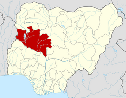
Wushishi

Last updated

Wushishi
wushishi
wsh
LGA and town
Motto: 
TOGETHER WE MAKE IT
CountryFlag of Nigeria.svg  Nigeria
State Niger State
Time zone UTC+1 (WAT)
Wushishi

Wushishi is a Local Government Area in Niger State, Nigeria. Its headquarters is in the town of Wushishi.

Wushishi is located between Longitude 9°43'N and Latitude 6°04'E and it has an area of 1,879 km2 and a population of 81,783 at the 2006 census.

The postal code of the area is 922. [1]

Climatic Condition

Temperatures rarely drop below or rise above 102°F in the humid, partly cloudy dry season of this hot and oppressive climate, which ranges from 61°F to 96°F. [2] [3]

From February 8 to April 22, the hot season, with an average daily high temperature exceeding 94°F, lasts for 2.4 months. Wushishi experiences the warmest month of the year in April, with an average high of 94°F and low of 76°F. [3]

With an average daily maximum temperature below 87°F, the chilly season lasts for 3.4 months, from June 25 to October 4. With an average low of 62°F and high of 90°F, December is the coldest month of the year in Wushishi. [2]

The average proportion of sky that is covered by clouds in Wushishi varies significantly seasonally throughout the year. [4]

In Wushishi, the clearer season starts about November 4 and lasts for 3.7 months, coming to a close around February 24. [5]

In Wushishi, January is the clearest month of the year, with the sky remaining clear, mostly clear, or partly overcast 57% of the time. [6]

Beginning about February 24 and lasting for 8.3 months, the cloudier season ends around November 4. [2]

May is the cloudiest month of the year in Wushishi, with the sky being overcast or mostly cloudy 82% of the time on average during this month. [4]

Related Research Articles

<span class="mw-page-title-main">Asaba</span> Capital city of Delta State, Nigeria

Asaba is the capital of Delta State, Nigeria. A rapidly growing city, it is located at the western bank of the Niger River, in the Oshimili South Local Government Area. Asaba had a population of 149,603 as at the 2006 census, and a fast growing metropolitan population of over half a million people.

Yenagoa is a Local Government Area and capital city of Bayelsa State, Southern Nigeria. It is located at the Niger-Delta region of the country at coordinates 4°55′29″N6°15′51″E.

Suleja is a city in Niger State, Nigeria, just north of Abuja, capital of the Nigeria. It is sometimes confused with the nearby city of Abuja, due to its proximity, and the fact that it was originally called Abuja before the Nigerian government adopted the name from the then Emir Sulayman Bal for its new federal capital in 1976.

Agaie is a Local Government Area in Niger State, Nigeria. Its headquarters are in the town of Agaie on the A124 highway.

Bende is a Local Government Area in Abia State, Nigeria with headquarters located in Bende Community. Bende Local Government Area (L.G.A) of Abia state lies on 70 30I of the Greenwich Meridian and latitude 50 30I North of the Equator. It is composed of thirteen (13) communities, namely: Alayi, Bende, Ezukwu, Igbere, Item, Itumbuzo, Nkpa, Ntalakwu, Ozuitem, Ugwueke, Umu-imenyi, Umuhu-Ezechi, and Uzuakoli.

Guyuk is a town and Local Government Area in Adamawa State, Nigeria. Guyuk has many limestone deposits. Guyuk is located along the Numan–Biu road.

Ankpa is a Local Government Area in Kogi State, Nigeria. Its headquarters are in the town of Ankpa on the A233 highway in the west of the area at7°22′14″N7°37′31″E.

Demsa is a Local Government Area of Adamawa State, Nigeria with headquarters located in Demsa. Demsa lies on the Benue River.

<span class="mw-page-title-main">Ganye</span> LGA and town in Adamawa State, Nigeria

Ganye is a town and Local Government Area of Adamawa State, Nigeria. Jada and Toungo Local Governments were carved out from Ganye local government area of Adamawa state Nigeria. Ganye is bordered by Jada Local Government Area to the North and East, Toungo Local Government Area to the South and Taraba State to the West. It is the headquarter of the Sama (Chamba) people worldwide.

<span class="mw-page-title-main">Gombi</span> An LGA and town in Adamawa State, Nigeria

Gombi is the Local Government Headquarter of Gombi Local Government Area of Adamawa State, Nigeria.

<span class="mw-page-title-main">Mubi North</span> LGA in Adamawa State, Nigeria

Mubi North is a Local Government Area of Adamawa State, Nigeria. The town is the location of the Adamawa State University and the Federal Polytechnic, Mubi.

Aba South is a Local Government Area of Abia State, Nigeria. Its headquarters are in the city of Aba.

Bagwai is a local government area in Kano State, Nigeria. Its headquarters is in the town of Bagwai.

<span class="mw-page-title-main">Birnin Gwari</span> LGA and town in Kaduna State, Nigeria

Birnin Gwari is a Local Government Area in Kaduna State, Nigeria. Its headquarters are in the town of Birnin Gwari.

Agwara is a Local Government Area in Niger State, Nigeria. Its headquarters are in the town of Agwara.

Rijau is a Local Government Area in Niger State, Nigeria. Its headquarters are in the town of Rijau.

Lau is a Local Government Area in Taraba State, Nigeria. Its headquarters is in the town of Lau and the area is dominated by Winlau people. Lau Local government has a border with Ardo Kola, Jalingo, Yorro and Zing local governments of Taraba state. It also shares a border with Numan, Adamawa State.

<span class="mw-page-title-main">Wukari</span> LGA and Town in Taraba State, Nigeria

Wukari is a Local Government Area in Taraba State, Nigeria. Its headquarters is in the town of Wukari on the A4 highway. The Donga River flows through the area and the Benue River forms a boundary with Nasarawa State to the northwest. It has an area of 4,308 km2 and a population of 241,546 at the 2006 census. The postal code of the area is 670.

Ife South is a Local Government Area in Osun State, Nigeria. Its headquarters are in the town of Ifetedo at 7°11′00″N4°42′00″E.

Ede North is a Local Government Area in Osun State, Nigeria. Its headquarters as Abere.

References

  1. "Post Offices- with map of LGA". NIPOST. Retrieved 2009-10-20.
  2. 1 2 3 "Wushishi Climate, Weather By Month, Average Temperature (Nigeria) - Weather Spark". weatherspark.com. Retrieved 2023-09-10.
  3. 1 2 "Wushishi, Niger, NG Climate Zone, Monthly Averages, Historical Weather Data". tcktcktck.org. Retrieved 2023-09-10.
  4. 1 2 "Weather Wushishi". meteoblue. 2023-09-25. Retrieved 2023-09-25.
  5. "Wushishi weather and climate ☀️ Best time to visit 🌡️ Temperature". www.besttimetovisit.co.nz. Retrieved 2023-09-25.
  6. "Wushishi weather forecast for today". justweather.org. Retrieved 2023-09-25.