Maytown, Florida

Last updated
Maytown
FEC Railway crossing at Maytown, Florida.jpg
The abandoned Florida East Coast Railway crossing in Maytown.
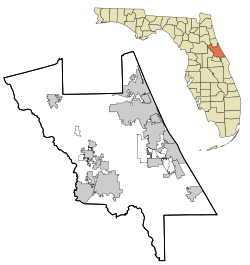
Volusia County Florida No Highlights.svg
Red pog.svg
Maytown
Coordinates: 28°48′26″N80°57′36″W / 28.80722°N 80.96000°W / 28.80722; -80.96000 Coordinates: 28°48′26″N80°57′36″W / 28.80722°N 80.96000°W / 28.80722; -80.96000
CountryFlag of the United States.svg  United States
State Flag of Florida.svg  Florida
County   Volusia
Elevation
30 ft (9 m)
Time zone UTC-5 (Eastern (EST))
  Summer (DST) UTC-4 (EDT)
enter ZIP code
32141
Area code(s) 386
GNIS feature ID286559 [1]

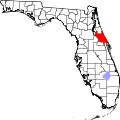
Maytown is an unincorporated community [2] located in south Volusia County, Florida, United States. The community was the site of the crossing of the Enterprise Branch and Kissimmee Valley Branch of the Florida East Coast Railway. Today, both lines are rail trails. [3] [4]
Related Research Articles

In the United States, a metropolitan statistical area (MSA) is a geographical region with a relatively high population density at its core and close economic ties throughout the area. Such regions are neither legally incorporated as a city or town would be, nor are they legal administrative divisions like counties or separate entities such as states; because of this, the precise definition of any given metropolitan area can vary with the source. The statistical criteria for a standard metropolitan area were defined in 1949 and redefined as metropolitan statistical area in 1983. A typical metropolitan area is centered on a single large city that wields substantial influence over the region. However, some metropolitan areas contain more than one large city with no single municipality holding a substantially dominant position. MSAs are defined by the U.S. Office of Management and Budget (OMB) and used by the Census Bureau and other federal government agencies for statistical purposes.

Chugach Mountains

The Chugach Mountains of southern Alaska are the northernmost of the several mountain ranges that make up the Pacific Coast Ranges of the western edge of North America. The range is about 250 miles (402 km) long and 60 miles (97 km) wide, and extends from the Knik and Turnagain Arms of the Cook Inlet on the west to Bering Glacier, Tana Glacier, and the Tana River on the east. It is bounded on the north by the Matanuska, Copper, and Chitina rivers. The highest point of the Chugach Mountains is Mount Marcus Baker, at 13,094 feet (3,991 m), but with an average elevation of 4,006 feet (1,221 m), most of its summits are not especially high. Even so, its position along the Gulf of Alaska ensures more snowfall in the Chugach than anywhere else in the world, an annual average of over 1500 cm (800 in).

Black Rock Desert Northwest Nevada dry lake

The Black Rock Desert is a semi-arid region of lava beds and playa, or alkali flats, situated in the Black Rock Desert–High Rock Canyon Emigrant Trails National Conservation Area, a silt playa 100 miles (160 km) north of Reno, Nevada that encompasses more than 300,000 acres (120,000 ha) of land and contains more than 120 miles (200 km) of historic trails. It is in the northern Nevada section of the Great Basin with a lakebed that is a dry remnant of Pleistocene Lake Lahontan.

Geographic Names Information System Geographical database

The Geographic Names Information System (GNIS) is a database of name and locative information about more than two million physical and cultural features throughout the United States and its territories, Antarctica, and the associated states of the Marshall Islands, Federated States of Micronesia, and Palau. It is a type of gazetteer. It was developed by the United States Geological Survey (USGS) in cooperation with the United States Board on Geographic Names (BGN) to promote the standardization of feature names.

The Advisory Committee on Antarctic Names is an advisory committee of the United States Board on Geographic Names responsible for recommending commemorative names for features in Antarctica.

The UK Antarctic Place-Names Committee is a United Kingdom government committee, part of the Foreign and Commonwealth Office, responsible for recommending names of geographical locations within the British Antarctic Territory (BAT) and the South Georgia and the South Sandwich Islands (SGSSI). Such names are formally approved by the Commissioners of the BAT and SGSSI respectively, and published in the BAT Gazetteer and the SGSSI Gazetteer maintained by the Committee. The BAT names are also published in the international Composite Gazetteer of Antarctica maintained by SCAR.

Lützow-Holm Bay is a large bay, about 220 kilometres (120 nmi) wide, indenting the coast of Queen Maud Land in Antarctica between Riiser-Larsen Peninsula and the coastal angle immediately east of the Flatvaer Islands. It was discovered by Captain Hjalmar Riiser-Larsen in two airplane flights from his expedition vessel, the Norvegia, on February 21 and 23, 1931. The name honours Commander Finn Lützow-Holm of the Royal Norwegian Navy Air Service, a pilot for Captain Riiser-Larsen on the Aagaard in 1935.

Hut Point Peninsula Landform on Ross Island, Antarctica

Hut Point Peninsula is a long, narrow peninsula from 3 to 5 km wide and 24 km (15 mi) long, projecting south-west from the slopes of Mount Erebus on Ross Island, Antarctica. McMurdo Station (US) and Scott Base (NZ) are Antarctic research stations located on the Hut Point Peninsula.

Gain Glacier is a large glacier on the east coast of Palmer Land, Antarctica, flowing northeast from Cat Ridge and entering the Weddell Sea between Imshaug Peninsula and Morency Island. It was mapped by the United States Geological Survey in 1974, and was named by the Advisory Committee on Antarctic Names for Louis Gain, a naturalist on the French Antarctic Expedition, 1908–10, and the author of several of the expedition reports on zoology and botany.

Irwin Glacier is a steep tributary glacier in the Bowers Mountains of Antarctica, draining northeast from Edlin Névé and at the terminus coalescing with Montigny Glacier, with which it enters the larger Graveson Glacier. The glacier was mapped by the United States Geological Survey from surveys and U.S. Navy air photos, 1960–64, and was named by the Advisory Committee on Antarctic Names for Carlisle S. Irwin, a former glaciologist who participated in the study of Meserve Glacier in 1966–67. The glacier lies situated on the Pennell Coast, a portion of Antarctica lying between Cape Williams and Cape Adare.

Jaburg Glacier is a broad glacier draining westward between the Dufek Massif and the Cordiner Peaks in the Pensacola Mountains of Antarctica. It was mapped by the United States Geological Survey from surveys and U.S. Navy air photos, 1956–66. The glacier was named by the Advisory Committee on Antarctic Names after Lieutenant Conrad J. Jaburg, U.S. Navy, a helicopter pilot with the Ellsworth Station winter party, 1957.

Horntvedt Glacier Glacier on Bouvet Island

Horntvedt Glacier is a small glacier flowing to the north coast of the island of Bouvetøya. It is situated immediately east of Cape Circoncision. It was first charted in 1898 by a German expedition under Carl Chun, and recharted in December 1927 by a Norwegian expedition which named it for Harald Horntvedt (1879-1946), the captain of the expedition ship Norvegia.

Posadowsky Glacier (Antarctica) Glacier in Antarctica

Posadowsky Glacier is a glacier about 9 nautical miles long, flowing north to Posadowsky Bay immediately east of Gaussberg. Posadowsky Bay is an open embayment, located just east of the West Ice Shelf and fronting on the Davis Sea in Kaiser Wilhelm II Land. Kaiser Wilhelm II Land is the part of East Antarctica lying between Cape Penck, at 87°43'E, and Cape Filchner, at 91°54'E, and is claimed by Australia as part of the Australian Antarctic Territory. Other notable geographic features in this area include Drygalski Island, located 45 mi NNE of Cape Filchner in the Davis Sea, and Mirny Station, a Russian scientific research station.

Balish Glacier Glacier in Antarctica

Balish Glacier is a glacier, 18 nautical miles (33 km) long, flowing north from the Soholt Peaks to enter Splettstoesser Glacier just northeast of Springer Peak, in the Heritage Range, Ellsworth Mountains. It was mapped by the United States Geological Survey from surveys and from U.S. Navy air photos, 1961–66, and was named by the Advisory Committee on Antarctic Names for Commander Daniel Balish, Executive Officer of U.S. Navy Squadron VX-6 during Operation Deep Freeze 1965, and Commanding Officer in 1967.

Blaiklock Glacier is a glacier 16 nautical miles (30 km) long, flowing north from Turnpike Bluff, then northwest to Mount Provender and Mount Lowe in the western part of the Shackleton Range, Antarctica. It was first mapped in 1957 by the Commonwealth Trans-Antarctic Expedition (CTAE), and named for Kenneth V. Blaiklock, the leader of the advance party of the CTAE in 1955–56 and a surveyor with the transpolar party in 1956–58.

Commandant Charcot Glacier Glacier in Antarctica

Commandant Charcot Glacier is a prominent glacier about 3 nautical miles (6 km) wide and 12 nautical miles (22 km) long, flowing north-northwest from the continental ice to its terminus at the head of Victor Bay. It was delineated from aerial photographs taken by U.S. Navy Operation Highjump, 1946–47. The French Antarctic Expedition, 1950–1952, under Mario Marret sledged west along the coast to Victor Bay, close east of this glacier, in December 1952, and it was named by them for the polar ship Commandant Charcot which transported French expeditions to this area, 1948–1952.

Coulston Glacier is a small tributary glacier flowing south from the Cartographers Range into Trafalgar Glacier, 10 nautical miles (19 km) west of Bypass Hill, in the Victory Mountains of Victoria Land. It was mapped by the United States Geological Survey from surveys and from U.S. Navy air photos 1960–64, and named by the Advisory Committee on Antarctic Names for Peter W. Coulston, an aviation electronics technician with U.S. Navy Squadron VX-6 at McMurdo Station, 1967.

Glen Glacier is a glacier at least 7 nautical miles (13 km) long, flowing south in the Shackleton Range of Antarctica to join Recovery Glacier to the west of the Read Mountains. It was first mapped in 1957 by the Commonwealth Trans-Antarctic Expedition (CTAE) and named for Alexander Richard "Sandy" Glen, a member of the Committee of Management of the CTAE, 1955–58.

Goldsmith Glacier is a glacier flowing west-northwest through the Theron Mountains of Antarctica, 6 nautical miles (11 km) south of Tailend Nunatak. It was first mapped in 1956–57 by the Commonwealth Trans-Antarctic Expedition (CTAE) and named for Rainer Goldsmith, medical officer with the advance party of the CTAE in 1955–56.

Henderson Glacier Glacier in Antarctica

Henderson Glacier is a glacier approximately 7 nautical miles long in the Enterprise Hills of the Heritage Range, Antarctica. It flows northeast from Schoeck Peak and Hoinkes Peak to enter Union Glacier just east of Mount Rossman. Henderson Glacier was mapped by the United States Geological Survey from surveys and U.S. Navy air photos 1961–66, and was named by the Advisory Committee on Antarctic Names for Felix E. Henderson, a United States Antarctic Research Program meteorologist at Eights Station in 1965.

References

  1. "US Board on Geographic Names". United States Geological Survey. 2007-10-25. Retrieved 2008-01-31.
  2. "Geographic Names Information System". USGS. Retrieved 25 August 2011.
  3. East Central Regional Rail Trail (100 Florida Trails)
  4. East Central Regional Rail Trail Map (Volusia County Parks, Recreation and Culture Division; January 2009)