Glencoe, Florida

Last updated
Glencoe, Florida
CDP
Volusia County Florida Incorporated and Unincorporated areas Glencoe Highlighted.svg
Location in Volusia County and the state of Florida
Coordinates: 29°0′35″N80°57′57″W / 29.00972°N 80.96583°W / 29.00972; -80.96583 Coordinates: 29°0′35″N80°57′57″W / 29.00972°N 80.96583°W / 29.00972; -80.96583
Country Flag of the United States.svg  United States
State Flag of Florida.svg  Florida
County   Volusia
Area
[1]
  Total3.47 sq mi (8.99 km2)
  Land3.47 sq mi (8.99 km2)
  Water0.00 sq mi (0.00 km2)
Elevation
20 ft (6 m)
Population
 (2020)
  Total2,170
  Density625.18/sq mi (241.40/km2)
Time zone UTC-5 (Eastern (EST))
  Summer (DST) UTC-4 (EDT)
FIPS code 12-26000 [2]
GNIS feature ID0283113 [3]

Glencoe is a census-designated place (CDP) in Volusia County, Florida, United States. The population was 2,582 at the 2010 census. [4]

Contents

Geography

Glencoe is located at 29°0′35″N80°57′57″W / 29.00972°N 80.96583°W / 29.00972; -80.96583 (29.009764, -80.965759). [5]

According to the United States Census Bureau, the CDP has a total area of 6.42 square miles (16.64 km2), of which 6.39 square miles (16.55 km2) is land, and 0.037 square miles (0.095 km2) (0.57%) is water. [6]

Demographics

Historical population
CensusPop.
2020 2,170
U.S. Decennial Census [7]

As of the census [2] of 2000, there were 2,485 people, 975 households, and 740 families residing in the CDP. The population density was 125.4/km2 (325.0/mi2). There were 1,033 housing units at an average density of 52.1/km2 (135.1/mi2). The racial makeup of the CDP was 97.99% White, 1.09% African American, 0.16% Native American, 0.12% Asian, 0.04% Pacific Islander, and 0.60% from two or more races. Hispanic or Latino of any race were 0.97% of the population.

There were 975 households, out of which 31.3% had children under the age of 18 living with them, 61.5% were married couples living together, 10.2% had a female householder with no husband present, and 24.1% were non-families. 18.9% of all households were made up of individuals, and 8.8% had someone living alone who was 65 years of age or older. The average household size was 2.54 and the average family size was 2.86.

In the CDP, the population was spread out, with 23.0% under the age of 18, 6.3% from 18 to 24, 26.9% from 25 to 44, 27.2% from 45 to 64, and 16.7% who were 65 years of age or older. The median age was 42 years. For every 100 females, there were 99.9 males. For every 100 females age 18 and over, there were 95.4 males.

The median income for a household in the CDP was $36,915, and the median income for a family was $45,958. Males had a median income of $36,383 versus $23,793 for females. The per capita income for the CDP was $21,816. About 4.6% of families and 5.6% of the population were below the poverty line, including 2.5% of those under age 18 and 4.3% of those age 65 or over.

Related Research Articles

West Crossett, Arkansas CDP in Arkansas, United States

West Crossett is a census-designated place (CDP) in Ashley County, Arkansas, United States. Per the 2020 census, the population was 1,144.

Cocoa West, Florida CDP in Florida, United States

Cocoa West is a census-designated place (CDP) in Brevard County, Florida, United States. The population was 5,925 at the 2010 census. It is the closest place to Lake Poinsett and Canaveral Groves.

June Park, Florida Census-designated place in Florida

June Park is a census-designated place (CDP) in Brevard County, Florida. The population was 4,094 at the 2010 United States Census. It is part of the Palm Bay–Melbourne–Titusville Metropolitan Statistical Area.

Broadview Park, Florida CDP in Florida, United States

Broadview Park is a census-designated place (CDP) in Broward County, Florida, United States. The population was 7,125 at the 2010 census.

Franklin Park is a census-designated place (CDP) in Broward County, Florida, United States. The population was 860 at the 2010 census.

Melrose Park (Fort Lauderdale) Neighborhood in Broward, Florida, United States

Melrose Park is a former census-designated place in Broward County, Florida, United States. The population was 7,114 at the 2000 census. On September 15, 2002, Melrose Park was annexed to the city of Fort Lauderdale, and is now a neighborhood.

Roosevelt Gardens is a census-designated place (CDP) in Broward County, Florida, United States. The population was 2,456 at the 2010 census.

Hernando Beach, Florida Census-designated area in Hernando County Florida, United States

Hernando Beach is a census-designated place (CDP) in Hernando County, Florida, United States. The population was 2,299 at the 2010 census.

West Vero Corridor, Florida Census-designated place in Florida, United States

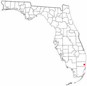
West Vero Corridor is a census-designated place (CDP) in Indian River County, Florida, United States. The population was 7,138 at the 2010 census, down from 7,695 at the 2000 census. It is part of the Sebastian–Vero Beach Metropolitan Statistical Area.

Altoona, Florida Census-designated place in Florida

Altoona is an unincorporated community and census-designated place (CDP) in Lake County, Florida, United States. The population was 89 at the 2010 census. It is part of the Orlando–Kissimmee–Sanford Metropolitan Statistical Area.

Harlem Heights, Florida Census-designated place in Florida, United States

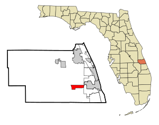
Harlem Heights is an unincorporated community and census-designated place (CDP) in Lee County, Florida, United States. The population was 1,975 at the 2010 census, up from 1,065 at the 2000 census. It is part of the Cape Coral-Fort Myers, Florida Metropolitan Statistical Area.

Tice, Florida Census-designated place in Florida, United States

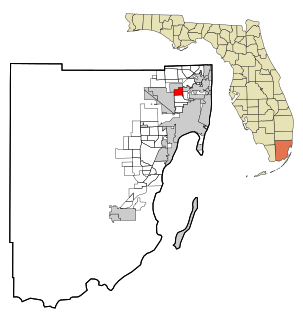
Tice is an unincorporated community and census-designated place (CDP) in Lee County, Florida, United States. As of the 2020 census, the CDP population was 4,853. It is part of the Cape Coral-Fort Myers, Florida Metropolitan Statistical Area.

Westview, Florida CDP in Florida, United States

Westview is a census-designated place (CDP) in Miami-Dade County, Florida, United States. The population was 9,923 at the 2020 census.

Ridgecrest, Florida Census-designated place in Florida, United States

Ridgecrest is a census-designated place (CDP) in Pinellas County, Florida, United States. The population was 2,558 at the 2010 census.

Highland, Vanderburgh County, Indiana Census-designated place in Indiana, United States

Highland is a census-designated place (CDP) in Center Township, Vanderburgh County, in the U.S. state of Indiana. The population was 4,489 at the 2010 census.

Lynchburg, Mississippi Census-designated place in Mississippi, United States

Lynchburg is an unincorporated area and census-designated place (CDP) in DeSoto County, Mississippi, United States. The population was 2,437 at the 2010 census.

Westgate, Florida Census-designated place in Florida, United States

Westgate is an unincorporated census-designated place (CDP) in Palm Beach County, Florida, United States. The population was 7,975 at the 2010 census. Prior to then it was listed as the Westgate-Belvedere Homes CDP.

Cuyamungue, New Mexico Census-designated place in New Mexico, United States

Cuyamungue is a census-designated place (CDP) in Santa Fe County, New Mexico, United States. It is part of the Santa Fe, New Mexico Metropolitan Statistical Area. The population was 479 at the 2010 census.

Carmel (hamlet), New York Hamlet and Census-designated place in New York, United States

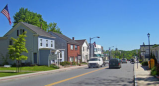
Carmel Hamlet, commonly known simply as Carmel, is a hamlet and census-designated place (CDP) located in the Town of Carmel in Putnam County, New York, United States. As of the 2010 census, the population was 6,817.

Pleasant Grove, Ohio CDP in Ohio, United States

Pleasant Grove is a census-designated place (CDP) in Muskingum County, Ohio, United States. The population was 2,016 at the 2000 census.

References

  1. "2020 U.S. Gazetteer Files". United States Census Bureau. Retrieved October 31, 2021.
  2. 1 2 "U.S. Census website". United States Census Bureau . Retrieved 2008-01-31.
  3. "US Board on Geographic Names". United States Geological Survey. 2007-10-25. Retrieved 2008-01-31.
  4. "Profile of General Population and Housing Characteristics: 2010 Demographic Profile Data (DP-1): Glencoe CDP, Florida". United States Census Bureau . Retrieved February 16, 2012.
  5. "US Gazetteer files: 2010, 2000, and 1990". United States Census Bureau. 2011-02-12. Retrieved 2011-04-23.
  6. "Geographic Identifiers: 2010 Demographic Profile Data (G001): Glencoe CDP, Florida". United States Census Bureau . Retrieved February 16, 2012.
  7. "Census of Population and Housing". Census.gov. Retrieved June 4, 2016.