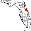
Samsula-Spruce Creek, Florida | |
---|---|
Coordinates: 29°3′41″N81°3′11″W / 29.06139°N 81.05306°W | |
Country | United States |
State | Florida |
County | Volusia |
Area | |
• Total | 16.82 sq mi (43.58 km2) |
• Land | 16.81 sq mi (43.53 km2) |
• Water | 0.02 sq mi (0.05 km2) |
Population (2020) | |
• Total | 4,877 |
• Density | 290.18/sq mi (112.04/km2) |
Time zone | UTC-5 (Eastern (EST)) |
• Summer (DST) | UTC-4 (EDT) |
FIPS code | 12-63362 [2] |
Samsula-Spruce Creek is a census-designated place (CDP) in Volusia County, Florida, United States. The population was 5,047 at the 2010 census. [3] While many households reside here, it is principally an agricultural area west of the cities of Port Orange and New Smyrna Beach.
Samsula-Spruce Creek is located at 29°3′41″N81°3′11″W / 29.06139°N 81.05306°W (29.061389, -81.052994). [4]
According to the United States Census Bureau, the CDP has a total area of 17.5 square miles (45.2 km2), of which 17.4 square miles (45.1 km2) is land and 0.039 square miles (0.1 km2), or 0.23%, is water. [5]
Census | Pop. | Note | %± |
---|---|---|---|
2010 | 5,047 | — | |
2020 | 4,877 | −3.4% | |
U.S. Decennial Census [6] |
At the 2000 census, [2] there were 4,877 people, 1,953 households and 1,511 families residing in the CDP. The population density was 94.5/km2 (244.9/mi2). There were 2,203 housing units at an average density of 42.7/km2 (110.6/mi2). The racial makeup of the CDP was 97.13% White, 0.33% African American, 0.33% Native American, 0.82% Asian, 0.08% Pacific Islander, 0.14% from other races, and 1.17% from two or more races. Hispanic or Latino of any race were 1.76% of the population. 21.1% were of German, 17.1% English, 9.1% Irish, 7.8% American and 6.1% Italian ancestry according to Census 2000.
There were 1,953 households, of which 25.6% had children under the age of 18 living with them, 68.7% were married couples living together, 5.5% had a female householder with no husband present, and 22.6% were non-families. 16.7% of all households were made up of individuals, and 6.5% had someone living alone who was 65 years of age or older. The average household size was 2.50 and the average family size was 2.79.
19.7% of the population were under the age of 18, 5.5% from 18 to 24, 21.9% from 25 to 44, 33.9% from 45 to 64, and 19.1% who were 65 years of age or older. The median age was 46 years. For every 100 females, there were 98.1 males. For every 100 females age 18 and over, there were 97.8 males.
The median household income was $59,427 and the median family income was $68,101. Males had a median income of $40,608 versus $24,390 for females. The per capita income was $33,084. About 4.5% of families and 5.4% of the population were below the poverty line, including 6.2% of those under age 18 and 6.7% of those age 65 or over.
Villas, Florida is an unincorporated community and census-designated place (CDP) in Lee County, Florida, United States. It is part of the Cape Coral-Fort Myers, Florida Metropolitan Statistical Area.
Whiskey Creek is a census-designated place (CDP) in Lee County, Florida, United States. The population was 4,842 at the 2020 census. It is part of the Cape Coral-Fort Myers, Florida Metropolitan Statistical Area.
Limestone Creek is a census-designated place (CDP) in Palm Beach County, Florida, United States. The population was 1,316 at the 2020 census.
South Wallins is an unincorporated community and census-designated place (CDP) in Harlan County, Kentucky, United States. The population was 859 at the 2010 census, down from 996 at the 2000 census.
Highview is a former census-designated place in Jefferson County, Kentucky, United States. The population was 15,161 at the 2000 census. On January 6, 2003, the area was annexed to the city of Louisville due to a merger between the city and Jefferson County's unincorporated communities. Highview is now a neighborhood within the city limits of Louisville.
Emmett Charter Township is a charter township of Calhoun County in the U.S. state of Michigan. It is part of the Battle Creek Metropolitan Statistical Area. The population was 11,770 at the 2010 census.
Erlton-Ellisburg was an unincorporated community and census-designated place (CDP) located within Cherry Hill Township, in Camden County, New Jersey, United States. As of the 2000 United States Census, the CDP's population was 8,168. The area comprises Erlton and Ellisburg, two neighborhoods in western Cherry Hill. As of the 2010 United States Census, the Erlton-Ellisburg CDP was discontinued and a portion of the old CDP was included in the new Ellisburg CDP.
Lake Katrine is a hamlet in Ulster County, New York, United States. The population was 2,522 at the 2020 census.
Lowesville is a census-designated place (CDP) in Lincoln County, North Carolina, United States. The population was 2,945 at the 2010 census, up from 1,440 in 2000.
Roseburg North is a census-designated place (CDP) in Douglas County, Oregon, United States. The population was 5,912 at the 2010 census. Winchester, Oregon is included as part of Roseburg North.
Fernville is a census-designated place (CDP) in Columbia County, Pennsylvania, United States. It is part of Northeastern Pennsylvania. The population was 556 at the 2010 census. It is part of the Bloomsburg-Berwick micropolitan area.
Rothsville is an unincorporated community and census-designated place (CDP) in Warwick Township, Lancaster County, Pennsylvania, United States. The population was 3,044 at the 2010 census. Lititz is the town for residents' mailing addresses.
Burnettown is a town in Aiken County, South Carolina, United States. The population was 3,105 at the 2020 census. It is part of the Augusta, Georgia metropolitan area. Burnettown is located in historic Horse Creek Valley.
Clearwater is a census-designated place (CDP) in Aiken County, South Carolina. It lies near North Augusta, South Carolina, and is part of the Augusta, Georgia metropolitan area. Clearwater is located in historic Horse Creek Valley. The population was 4,370 at the time of the 2010 census.
Gloverville is a census-designated place (CDP) in Aiken County, South Carolina, United States. The population was 2,831 at the 2010 census. It is part of the Augusta, Georgia metropolitan area. Gloverville is located in historic Horse Creek Valley.
Socastee is a census-designated place (CDP) in Horry County, South Carolina, United States. The population was 19,952 at the 2010 census.
Red Bank is an unincorporated community and census-designated place (CDP) in Lexington County, South Carolina, United States. The population was 9,617 at the 2010 census, up from 8,811 at the 2000 census. It is part of the Columbia, South Carolina Metropolitan Statistical Area.
Lakewood is a census-designated place (CDP) in Sumter County, South Carolina, United States. The population was 2,603 at the 2000 census. It is included in the Sumter, South Carolina Metropolitan Statistical Area.
Arlington Heights is a census-designated place (CDP) in Snohomish County, Washington, United States. The population was 2,284 at the 2010 census.
Gilbert Creek is a census-designated place (CDP) in Mingo County, West Virginia, United States. The population was 1,090 at the 2010 census. The community takes its name from nearby Gilbert Creek.