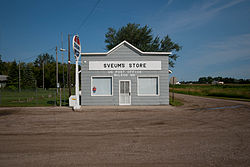
McLeod | |
---|---|
Coordinates: 46°23′19″N97°17′55″W / 46.38861°N 97.29861°W | |
Country | United States |
State | North Dakota |
County | Ransom |
Area | |
• Total | 0.77 sq mi (2.00 km2) |
• Land | 0.77 sq mi (2.00 km2) |
• Water | 0.00 sq mi (0.00 km2) |
Elevation | 1,076 ft (328 m) |
Population (2020) | |
• Total | 22 |
• Density | 28.42/sq mi (10.98/km2) |
Time zone | UTC-6 (Central (CST)) |
• Summer (DST) | UTC-5 (CDT) |
ZIP codes | 58057 |
Area code | 701 |
FIPS code [3] | 38-49540 |
GNIS feature ID | 2584351 [2] |
McLeod (also Sandoun) is a census designated place in eastern Ransom County, North Dakota, United States. An unincorporated community, it was designated as part of the U.S. Census Bureau's Participant Statistical Areas Program on March 31, 2010. [2] It was not counted separately during the 2000 Census, [4] but was included in the 2010 Census, where its population was reported to be 27. [5] [6]
The community lies along North Dakota Highway 27 east of the city of Lisbon, the county seat of Ransom County. [2] Originally named Sandoun for the many sand dunes in the area, it was renamed McLeod for local realtor J. J. McLeod. [7]
Census | Pop. | Note | %± |
---|---|---|---|
2020 | 22 | — | |
U.S. Decennial Census [8] |
This climatic region is typified by large seasonal temperature differences, with warm to hot (and often humid) summers and cold (sometimes severely cold) winters. According to the Köppen Climate Classification system, McLeod has a humid continental climate, abbreviated "Dfb" on climate maps. [9]
Climate data for McLeod 3E, North Dakota (1991–2020 normals, extremes 1912–present) | |||||||||||||
---|---|---|---|---|---|---|---|---|---|---|---|---|---|
Month | Jan | Feb | Mar | Apr | May | Jun | Jul | Aug | Sep | Oct | Nov | Dec | Year |
Record high °F (°C) | 60 (16) | 66 (19) | 86 (30) | 99 (37) | 106 (41) | 105 (41) | 114 (46) | 107 (42) | 105 (41) | 97 (36) | 78 (26) | 68 (20) | 114 (46) |
Average high °F (°C) | 19.0 (−7.2) | 24.0 (−4.4) | 37.6 (3.1) | 54.5 (12.5) | 68.7 (20.4) | 78.0 (25.6) | 82.5 (28.1) | 81.4 (27.4) | 72.7 (22.6) | 56.8 (13.8) | 39.1 (3.9) | 24.8 (−4.0) | 53.3 (11.8) |
Daily mean °F (°C) | 8.9 (−12.8) | 13.5 (−10.3) | 27.1 (−2.7) | 43.0 (6.1) | 56.7 (13.7) | 66.8 (19.3) | 71.1 (21.7) | 69.2 (20.7) | 60.2 (15.7) | 45.4 (7.4) | 29.5 (−1.4) | 15.6 (−9.1) | 42.2 (5.7) |
Average low °F (°C) | −1.3 (−18.5) | 2.9 (−16.2) | 16.7 (−8.5) | 31.4 (−0.3) | 44.6 (7.0) | 55.7 (13.2) | 59.7 (15.4) | 57.0 (13.9) | 47.6 (8.7) | 33.9 (1.1) | 19.9 (−6.7) | 6.4 (−14.2) | 31.2 (−0.4) |
Record low °F (°C) | −41 (−41) | −41 (−41) | −30 (−34) | −7 (−22) | 11 (−12) | 27 (−3) | 37 (3) | 31 (−1) | 15 (−9) | −12 (−24) | −28 (−33) | −36 (−38) | −41 (−41) |
Average precipitation inches (mm) | 0.62 (16) | 0.72 (18) | 1.00 (25) | 1.67 (42) | 2.89 (73) | 4.52 (115) | 3.48 (88) | 2.63 (67) | 2.56 (65) | 2.16 (55) | 0.85 (22) | 0.89 (23) | 23.99 (609) |
Average precipitation days (≥ 0.01 in) | 3.4 | 4.0 | 3.8 | 4.6 | 7.6 | 9.0 | 7.8 | 6.6 | 5.5 | 5.7 | 3.2 | 4.1 | 65.3 |
Source: NOAA [10] [11] |
Willow City is a city in Bottineau County, North Dakota, United States. The population was 149 at the 2020 census. Willow City was founded in 1887.
Dunn Center is a city in Dunn County, North Dakota, United States. The population was 227 at the 2020 census. Dunn Center was founded in 1914.
McHenry is a city in Foster County, North Dakota, United States. The population was 64 at the 2020 census. McHenry was founded in 1899.
Edgeley is a city in LaMoure County, North Dakota, United States. The population was 585 at the 2020 census.
Napoleon is a city in Logan County, North Dakota, United States. It is the county seat of Logan County. The population was 749 at the 2020 census.
Towner is a city in McHenry County, North Dakota. It is the county seat of McHenry County. The population was 479 at the time of the 2020 census. It is part of the Minot Micropolitan Statistical Area. Towner was founded in 1886.
Upham is a city in McHenry County, North Dakota, United States. The population was 135 at the 2020 census. It is part of the Minot Micropolitan Statistical Area. Upham was founded in 1905.
Watford City, founded in 1914, is a city in and the county seat of McKenzie County, North Dakota, United States. The population was 6,207 at the 2020 census, making it the thirteenth largest city in North Dakota. Because Watford City is part of the Bakken field, the North Dakota oil boom has significantly increased population and construction since the 2010 census.
Riverdale is a town in McLean County, North Dakota, United States. The population was 223 at the 2020 census.
Underwood is a city in McLean County, North Dakota, United States. The population was 784 at the 2020 census.
Almont is a city in Morton County, North Dakota, United States. It is part of the "Bismarck, ND Metropolitan Statistical Area" or "Bismarck–Mandan". The population was 100 at the 2020 census. Almont was founded in 1906, incorporated in 1936, and reached a peak population of 232 in 1940. The Northern Pacific Railroad tracks were removed in 1947 when the mainline was rerouted, and the city has since withered to just above 100 residents.
Petersburg is a city in Nelson County, North Dakota, United States. The population was 162 at the time of the 2020 census. Petersburg was founded in 1884.
Center is a city in Oliver County, North Dakota, United States. It is the county seat of, and the only incorporated place in, Oliver County. The population was 588 at the 2020 census.
Rugby is a city in, and the county seat of, Pierce County, North Dakota, United States. The population was 2,509 at the 2020 census, making it the 19th largest city in North Dakota. Rugby was founded in 1886.
McClusky is a city in Sheridan County, North Dakota, United States. It is the county seat of Sheridan County. The population was 322 at the 2020 census. McClusky was founded in 1905. It is the closest town to the geographical center of North Dakota, which lies approximately five miles to the southwest.
Kenmare is a city in Ward County, North Dakota, United States. The population was 961 at the 2020 census. Kenmare is part of the Minot Micropolitan Statistical Area.
Enderlin is a city in Cass and Ransom counties in the State of North Dakota. The population was 881 at the 2020 census.
Keene is an unincorporated community in McKenzie County, North Dakota in the United States. It has the ZIP code of 58847, which includes surrounding farmland. In this zip code area, the 2000 census found 258 people.
Manning is a small town in, and the county seat of, Dunn County, North Dakota, United States. Manning was founded in 1908 to serve as the seat of Dunn County, itself organized that year. Its population was not reported in the 2000 census, but was included in the 2020 census, where a population of 47 was given. Its ZIP Code is 58642.
Menoken is an unincorporated community and a census-designated place (CDP) in southwestern Burleigh County, North Dakota, United States. It was designated as part of the U.S. Census Bureau's Participant Statistical Areas Program on June 10, 2010. It was not counted separately during the 2000 Census, but was included in the 2010 Census, where a population of 70 was reported.