Elliott, North Dakota

Last updated

Elliott
Elliott City Park Sign - Elliott, North Dakota 6-12-2008.jpg
Elliott City Park Sign
ND Ransom County Elliott.svg
Coordinates: 46°24′08″N97°48′54″W / 46.40222°N 97.81500°W / 46.40222; -97.81500
CountryUnited States
State North Dakota
County Ransom
Founded1883
Area
[1]
  Total0.15 sq mi (0.40 km2)
  Land0.15 sq mi (0.40 km2)
  Water0.00 sq mi (0.00 km2)
Elevation
[2]
1,335 ft (407 m)
Population
 (2020) [3]
  Total24
  Estimate 
(2022) [4]
21
  Density156.86/sq mi (60.68/km2)
Time zone UTC–6 (Central (CST))
  Summer (DST) UTC–5 (CDT)
ZIP Code
58054
Area code 701
FIPS code 38-23340
GNIS feature ID1036022 [2]

Elliott is a city in Ransom County, North Dakota, United States. The population was 24 at the 2020 census. [3] Elliott was founded in 1883.

Contents

Geography

According to the United States Census Bureau, the city has a total area of 0.15 square miles (0.39 km2), all land. [5]

Demographics

Historical population
CensusPop.Note
1930 106
1940 11811.3%
1950 87−26.3%
1960 62−28.7%
1970 50−19.4%
1980 44−12.0%
1990 32−27.3%
2000 4437.5%
2010 25−43.2%
2020 24−4.0%
2022 (est.)21 [4] −12.5%
U.S. Decennial Census [6]
2020 Census [3]

2010 census

As of the census of 2010, there were 25 people, 12 households, and 7 families residing in the city. The population density was 166.7 inhabitants per square mile (64.4/km2). There were 15 housing units at an average density of 100.0 per square mile (38.6/km2). The racial makeup of the city was 92.0% White, 4.0% Asian, and 4.0% from two or more races.

There were 12 households, of which 16.7% had children under the age of 18 living with them, 58.3% were married couples living together, and 41.7% were non-families. 25.0% of all households were made up of individuals, and 8.3% had someone living alone who was 65 years of age or older. The average household size was 2.08 and the average family size was 2.43.

The median age in the city was 56.5 years. 8% of residents were under the age of 18; 4% were between the ages of 18 and 24; 24% were from 25 to 44; 44% were from 45 to 64; and 20% were 65 years of age or older. The gender makeup of the city was 44.0% male and 56.0% female.

2000 census

As of the census of 2000, there were 44 people, 17 households, and 10 families residing in the city. The population density was 295.6 inhabitants per square mile (114.1/km2). There were 18 housing units at an average density of 120.9 per square mile (46.7/km2). The racial makeup of the city was 93.18% White, 2.27% Asian, and 4.55% from two or more races.

There were 17 households, out of which 29.4% had children under the age of 18 living with them, 64.7% were married couples living together, and 35.3% were non-families. 23.5% of all households were made up of individuals, and 5.9% had someone living alone who was 65 years of age or older. The average household size was 2.59 and the average family size was 3.18.

In the city, the population was spread out, with 22.7% under the age of 18, 15.9% from 18 to 24, 25.0% from 25 to 44, 27.3% from 45 to 64, and 9.1% who were 65 years of age or older. The median age was 35 years. For every 100 females, there were 100.0 males. For every 100 females age 18 and over, there were 126.7 males.

The median income for a household in the city was $40,625, and the median income for a family was $43,750. Males had a median income of $26,250 versus $0 for females. The per capita income for the city was $15,692. None of the population and none of the families were below the poverty line.

Related Research Articles

<span class="mw-page-title-main">Hayesville, Iowa</span> City in Iowa, United States

Hayesville is a city in Keokuk County, Iowa, United States. The population was 41 at the time of the 2020 census.

<span class="mw-page-title-main">Webster, Iowa</span> City in Iowa, United States

Webster is a city in Keokuk County, Iowa, United States. The population was 94 at the time of the 2020 census.

<span class="mw-page-title-main">Elliott, Iowa</span> City in Iowa, United States

Elliott is a city in Montgomery County, Iowa, United States, along the East Nishnabotna River. The population was 338 at the time of the 2020 census.

<span class="mw-page-title-main">Rolfe, Iowa</span> City in Iowa, United States

Rolfe is a city in Pocahontas County, Iowa, United States. The population was 509 at the time of the 2020 census.

<span class="mw-page-title-main">Marysville, Kansas</span> City in Marshall County, Kansas

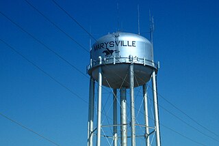
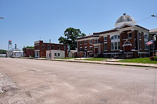
Marysville is a city in and the county seat of Marshall County, Kansas, United States. As of the 2020 census, the population of the city was 3,447.

<span class="mw-page-title-main">Watertown, Minnesota</span> City in Minnesota, United States

Watertown is a small city in Carver County, Minnesota, United States, along the South Fork of the Crow River, on the outskirts of the Twin Cities metro area. The population was 4,659 at the 2020 census.

<span class="mw-page-title-main">Deer Creek, Minnesota</span> City in Minnesota, United States

Deer Creek is a city in Otter Tail County, Minnesota, United States. The population was 330 at the 2020 census.

<span class="mw-page-title-main">Urbank, Minnesota</span> City in Minnesota, United States

Urbank is a city in Otter Tail County, Minnesota, United States. The population was 52 at the 2020 census.

<span class="mw-page-title-main">Leonidas, Minnesota</span> City in Minnesota, United States

Leonidas is a city in Saint Louis County, Minnesota, United States. The population was 52 at the 2010 census.

<span class="mw-page-title-main">Winchester, Missouri</span> City in Missouri, United States

Winchester is a city in St. Louis County, Missouri, United States. The population was 1,447 at the 2020 census.

<span class="mw-page-title-main">Kathryn, North Dakota</span> City in North Dakota, United States

Kathryn is a city in Barnes County, North Dakota, United States. The population was 66 at the 2020 census. Kathryn was founded in 1900. It was named after the daughter of a railroad man.

<span class="mw-page-title-main">Esmond, North Dakota</span> City in North Dakota, United States

Esmond is a city in Benson County, North Dakota, United States. The population was 91 at the 2020 census. Esmond was founded in 1901.

<span class="mw-page-title-main">Gardena, North Dakota</span> City in North Dakota, United States

Gardena is a city in Bottineau County, North Dakota, United States. The population was 24 at the 2020 census. Gardena was founded in 1905.

<span class="mw-page-title-main">Kramer, North Dakota</span> City in North Dakota, United States

Kramer is a city in Bottineau County, North Dakota, United States. The population was 24 at the 2020 census. Kramer was founded in 1905.

<span class="mw-page-title-main">Ayr, North Dakota</span> City in North Dakota, United States

Ayr is a city in Cass County, North Dakota, United States. The population was 11 at the 2020 census. Ayr was founded in 1883.

<span class="mw-page-title-main">Briarwood, North Dakota</span> City in North Dakota, United States

Briarwood is a city in Cass County, North Dakota, United States. The population was 57 at the 2020 census. Briarwood was founded in 1973. It is a suburb directly adjacent to the city of Fargo.

<span class="mw-page-title-main">North River, North Dakota</span> City in North Dakota, United States

North River is a city in Cass County, North Dakota, United States. The population was 55 at the 2020 census. North River was founded in 1973. It is a suburb/bedroom community directly adjacent to the city of Fargo.

<span class="mw-page-title-main">Prairie Rose, North Dakota</span> City in North Dakota, United States

Prairie Rose is a city in Cass County, North Dakota, United States. The population was 56 at the 2020 census. The city is an enclave suburb of Fargo. Prairie Rose was founded in 1975 and it was incorporated in 1978. There are 21 homes in the city.

<span class="mw-page-title-main">Calio, North Dakota</span> City in North Dakota, United States

Calio is a city in Cavalier County, North Dakota, United States. The population was 8 at the 2020 census. Calio was founded in 1905.

<span class="mw-page-title-main">War, West Virginia</span> City in West Virginia, United States

War is a city in McDowell County, West Virginia, United States. The population was 690 at the 2020 census. War was incorporated in 1920 by the Circuit Court of McDowell County. Its name is derived from War Creek, whose confluence with Dry Fork is located within the city. War is the only place in the United States with this name. War was formerly known as Miner's City. It is also known for being a setting in the movie October Sky; as writer Homer Hickam's Big Creek High School.

References

  1. "2020 U.S. Gazetteer Files". United States Census Bureau. Retrieved July 24, 2022.
  2. 1 2 U.S. Geological Survey Geographic Names Information System: Elliott, North Dakota
  3. 1 2 3 "Explore Census Data". United States Census Bureau . Retrieved January 16, 2024.
  4. 1 2 "City and Town Population Totals: 2020-2022". United States Census Bureau. January 16, 2024. Retrieved January 16, 2024.
  5. "US Gazetteer files 2010". United States Census Bureau. Archived from the original on January 25, 2012. Retrieved June 14, 2012.
  6. United States Census Bureau. "Census of Population and Housing" . Retrieved January 30, 2014.