Mechanicsburg, West Virginia

Last updated
Mechanicsburg, West Virginia
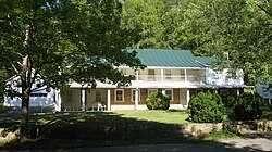
The Burg Mechanicsburg WV 2010 08 28 03.JPG
"The Burg"
USA West Virginia location map.svg
Red pog.svg
Mechanicsburg
Usa edcp location map.svg
Red pog.svg
Mechanicsburg
Coordinates: 39°20′7″N78°48′37″W / 39.33528°N 78.81028°W / 39.33528; -78.81028 Coordinates: 39°20′7″N78°48′37″W / 39.33528°N 78.81028°W / 39.33528; -78.81028
Country United States
State West Virginia
County Hampshire
Time zone UTC-5 (Eastern (EST))
  Summer (DST) UTC-4 (EDT)
GNIS feature ID1549817 [1]

Mechanicsburg, also known as Mechanicsville, is an unincorporated community in Hampshire County, West Virginia, United States. It is located on the Northwestern Turnpike (U.S. Route 50) west of Romney at Mill Creek Gap (sometimes referred to as Mechanicsburg Gap). Mechanicsburg is the site of "The Burg" (c. 1769), used as a headquarters by both armies during the American Civil War. Along Fox Hollow Road (County Route 50/4) lies the 19th-century Fox's Hollow Baptist Church and the old Mechanicsburg School.

The Fox's Hollow area of Mechanicsburg is currently experiencing major residential development, including Silver Leaf, a community of wooded five and 10-acre (40,000 m2) lots.

Related Research Articles

Cacapon River

The Cacapon River, located in the Appalachian Mountains of West Virginia's Eastern Panhandle region, is an 81.0-mile-long (130.4 km) river known for its fishing, boating, wildlife, and scenery. As part of the Potomac River watershed, it is an American Heritage River.

The Northwestern Turnpike is a historic road in West Virginia, important for being historically one of the major roads crossing the Appalachians, financed by the Virginia Board of Public Works in the 1830s. In modern times, west of Winchester, Virginia, U.S. Route 50 follows the path of the Northwestern Turnpike into West Virginia, whose major Corridor D project follows the western section of the original Northwestern Turnpike.

U.S. Route 48 (US 48), also known as the incomplete Corridor H of the Appalachian Development Highway System, extends from Interstate 79 (I-79) in Weston, West Virginia eastward across the crest of the Allegheny Mountains to I-81 in Strasburg, Virginia. It is planned to extend 157 miles (253 km) from west northern Virginia to central West Virginia.

Hanging Rock, West Virginia Unincorporated community in West Virginia, United States

Hanging Rock is an unincorporated community in Hampshire County in the U.S. state of West Virginia. Hanging Rock is named for the "Hanging Rock" outcrop that hangs over the Northwestern Turnpike. It should not be confused with the plural "Hanging Rocks" over the South Branch Potomac River north of Romney at Wapocomo. Originally, the community of Hanging Rock sprang up in the Henderson Hollow gap of North River Mountain. While only a few buildings of the old hamlet remain, today's Hanging Rock is situated at the intersection of North River Road and Delray Road where the North River flows under U.S. Route 50 towards the Cacapon.

Frenchburg, West Virginia Unincorporated community in West Virginia, United States

Frenchburg is an unincorporated community in Hampshire County in the U.S. state of West Virginia. Frenchburg is located along the Northwestern Turnpike where the Little Cacapon River is formed by the confluence of the North and South forks of the Little Cacapon east of Shanks. Frenchburg is also the location of the southern terminus of Little Cacapon River Road on U.S. Route 50. Frenchburg is primarily known for the events that took place there during the American Civil War.

Little Cacapon River

The Little Cacapon River is a 25.1-mile-long (40.4 km) free-flowing tributary of the Potomac River in the center of Hampshire County, West Virginia. Via the Potomac River, its waters are part of the Chesapeake Bay watershed, leading to the Atlantic Ocean. The Little Cacapon enters the Potomac at an elevation of 499 feet (152 m) near the community of Little Cacapon. For the majority of its course the Little Cacapon is a shallow non-navigable stream. It has been historically referred to as both Little Cacapehon and Little Capecaphon. The name is pronounced kə-KAY-pən or KAY-pən.

Bluemont, Virginia Unincorporated community in Virginia

Bluemont is an unincorporated village in Loudoun County, Virginia located at the eastern base of Snickers Gap in the Blue Ridge Mountains. The village's center is located along Snickersville Turnpike, 4 miles (6.4 km) west of the incorporated town of Round Hill. The village borders Virginia's fox hunting country and is within 1 mile (1.6 km) of the Appalachian Trail and the Bears Den and Raven Rocks formations in the Blue Ridge.

Loom, West Virginia Unincorporated community in West Virginia, United States

Loom is an unincorporated community in Hampshire County, West Virginia, United States. Loom is located between Capon Bridge and Hanging Rock along the Northwestern Turnpike on the western flanks of Cooper Mountain. Timber Mountain Road and Beck's Gap Road converge at Loom on U.S. Route 50.

Dillons Run

Dillons Run is a 12.9-mile-long (20.8 km) tributary stream of the Cacapon River, belonging to the Potomac River and Chesapeake Bay watersheds. The stream is located in Hampshire County in the U.S. state of West Virginia's Eastern Panhandle.

Fort Mill Ridge Civil War Trenches United States historic place

The Fort Mill Ridge Civil War Trenches are battle trenches in West Virginia that were originally dug between 1861 and 1862 to be later used in 1863 for the civil war. These trenches lined with chestnut logs by the Confederate artillery during the American Civil War to defend the approaches to Romney on the Northwestern Turnpike and the South Branch Potomac River. The trenches were then refurbished between March and June 1863 by the 54th Pennsylvania Infantry and the 1st West Virginia Infantry. When Colonel Jacob M. Campbell garrisoned Union forces at Romney, camps were set up at nearby at Mechanicsburg Gap. The Confederates might have created these trenches but all throughout the war the Union had control of these trenches.

Mill Creek Mountain

Mill Creek Mountain is a continuous mountain ridge that runs northeast through Hampshire and Hardy counties in the Eastern Panhandle region of the U.S. state of West Virginia. Rising to its greatest elevation of 2,650 feet (808 m) at High Knob, Mill Creek is a folded mountain ridge, belonging to the Ridge-and-Valley Appalachians. Mill Creek Mountain forms the western edge of the South Branch Potomac River Valley and is named for Mill Creek that carves through it at Mechanicsburg Gap allowing the Northwestern Turnpike to pass through as well. Along with Sawmill Ridge, Mill Creek Mountain forms the Trough along the South Branch.

Cherry Run

Cherry Run is a 7.2-mile-long (11.6 km) meandering stream that forms the northern section of the boundary between Morgan and Berkeley counties in West Virginia's Eastern Panhandle. While it is mostly non-navigable, Cherry Run provides many pools of varying depths for fishing and swimming. As a tributary of the Potomac River, Cherry Run is part of the Potomac and Chesapeake Bay watersheds.

Mill Creek (South Branch Potomac River tributary)

Mill Creek is a 14.0-mile-long (22.5 km) tributary stream of the South Branch Potomac River, belonging to the Potomac River and Chesapeake Bay watersheds. The stream is located in Hampshire County in West Virginia's Eastern Panhandle. Mill Creek flows into the South Branch west of Romney Bridge near Vanderlip along the Northwestern Turnpike.

Mechanicsburg Gap

Mechanicsburg Gap is a water gap through Mill Creek Mountain in Hampshire County in the U.S. state of West Virginia.

U.S. Route 50 is a transcontinental highway which stretches from Ocean City, Maryland to West Sacramento, California. In the U.S. state of Virginia, US 50 extends 86 miles (138 km) from the border with Washington, D.C. at a Potomac River crossing at Rosslyn in Arlington County to the West Virginia state line near Gore in Frederick County.

Powell Mountain is a mountain ridge of the Ridge-and-valley Appalachians of the Appalachian Mountains. It is a long and narrow ridge, running northeast to southwest, from about Norton, Virginia to near Tazewell, Tennessee. It separates the Clinch River basin and the Powell River basin of Powell Valley. It was named for an 18th-century explorer.

Virginia State Route 42

State Route 42 is a primary state highway in the U.S. state of Virginia. Running parallel to and west of Interstate 81, SR 42 consists of three sections with gaps filled by secondary routes in between. Some of SR 42 lies along the old Fincastle Turnpike. Another major piece, from near Clifton Forge to Buffalo Gap, parallels the old Virginia Central Railroad.

North River (Cacapon River tributary)

The North River is a tributary of the Cacapon River, belonging to the Potomac River and Chesapeake Bay watersheds. The river is located in Hampshire and Hardy counties in the U.S. state of West Virginia's Eastern Panhandle. The mouth of the North River into the Cacapon is located at Forks of Cacapon. From its headwaters to its mouth, the North River spans 52.4 miles (84.3 km) in length.

References

Commons-logo.svg Media related to Mechanicsburg, West Virginia at Wikimedia Commons