
The Potomac River is located within the Mid-Atlantic region of the United States and flows from the Potomac Highlands into the Chesapeake Bay. The river is approximately 405 miles (652 km) long, with a drainage area of about 14,700 square miles (38,000 km2). In terms of area, this makes the Potomac River the fourth largest river along the Atlantic coast of the United States and the 21st largest in the United States. Over 5 million people live within the Potomac watershed.

Chantilly is a census-designated place (CDP) in western Fairfax County, Virginia, United States. The population was 23,039 at the 2010 census. Chantilly is named after an early-19th-century mansion and farm, which in turn took the name of an 18th-century plantation that was located in Westmoreland County, Virginia. The name "Chantilly" originated in France with the Château de Chantilly, about 25 miles north of Paris.

Mount Vernon is a census-designated place (CDP) and unincorporated community in Fairfax County, Virginia, United States. The population was 12,416 at the 2010 census. Primarily due to its historical significance and natural recreation and beauty, the Mount Vernon area receives over one million touring visitors each year.
Ridgedale has multiple meanings, including:

Springfield is a census-designated place (CDP) in northwestern Hampshire County in the U.S. state of West Virginia. As of the 2010 census, Springfield had a population of 477. Springfield is located north of Romney along West Virginia Route 28 at its junction with Green Spring Road and Springfield Pike. It is currently considering incorporation.

Glebe was an unincorporated community in Hampshire County, West Virginia, United States. It is situated at the lower mouth of the Trough, a gorge of the South Branch Potomac River, and is about 9.5 miles (15.3 km) southwest of Romney on South Branch River Road. The community received its name from the old stone glebehouse (parsonage) that was constructed there in the late 18th century. The stone house later became the Hampshire County Poor Farm and remains standing. The community of Sector lies directly across the river.

Wappocomo is an unincorporated community in Hampshire County in the U.S. state of West Virginia. The community is located south of Springfield on West Virginia Route 28 at Hanging Rocks along the South Branch Potomac River. Wappocomo has also historically been referred to as The Rocks, Wapocoma, and Wapocomo.
Hanging Rocks are perpendicular cliffs rising nearly 300 feet (91 m) above the South Branch Potomac River in Hampshire County in the U.S. state of West Virginia. Hanging Rocks are located four miles (6 km) north of Romney at Wappocomo on West Virginia Route 28. Hanging Rocks has also been known throughout its history as Painted Rocks and Blue's Rocks. When distinguished from the "Lower Hanging Rocks" along the South Branch at Blues Beach to the north, Hanging Rocks is referred to as Upper Hanging Rocks.
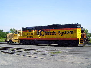
The South Branch Valley Railroad consists of a 52.4 mile (84.33 km) length of railroad in the U.S. state of West Virginia extending north along the South Branch Potomac River from Petersburg to the CSXT mainline at Green Spring adjacent to the Potomac River. At Green Spring, the CSXT mainline connects the SBVR to Cumberland, Maryland to the west and Martinsburg, West Virginia to the east. SBVR has been owned and operated by the West Virginia State Rail Authority (SRA) since it was sold by the Baltimore & Ohio Railroad on October 11, 1978. Upon purchasing the B&O's South Branch line, West Virginia became the first state in the United States to both own and operate a commercial freight railroad. In 1985, major flooding of the South Branch Valley destroyed most of the rail line, including all three bridges that crossed the South Branch Potomac River. Despite talk of shutting down the railroad after the flood, reconstruction began two years later.

Indian Mound Cemetery is a cemetery located along the Northwestern Turnpike on a promontory of the "Yellow Banks" overlooking the South Branch Potomac River and Mill Creek Mountain in Romney, West Virginia, United States. The cemetery is centered on a Hopewellian mound, known as the Romney Indian Mound. Indian Mound Cemetery is also the site of Fort Pearsall, the Confederate Memorial, Parsons Bell Tower, and reinterments from Romney's Old Presbyterian Cemetery. The cemetery is currently owned and maintained by the Indian Mound Cemetery Association, Inc.

Edwards Run is a 7.9-mile-long (12.7 km) tributary stream of the Cacapon River, belonging to the Potomac River and Chesapeake Bay watersheds. The stream is located in Hampshire County in the U.S. state of West Virginia's Eastern Panhandle. Edwards Run is named for Joseph Edwards and his family, whose plantation encompassed most of the stream's course. George Washington surveyed his property in the late 1740s. It is a major source of various species of elodea.

Donaldson is an unincorporated community in Hampshire County in the U.S. state of West Virginia. It is located in Green Spring Valley on Green Spring Road between Green Spring and Springfield. Donaldson was once a thriving railroad community along the South Branch Valley Railroad with its own school and post office in operation.

Mill Creek is a 14.0-mile-long (22.5 km) tributary stream of the South Branch Potomac River, belonging to the Potomac River and Chesapeake Bay watersheds. The stream is located in Hampshire County in West Virginia's Eastern Panhandle. Mill Creek flows into the South Branch west of Romney Bridge near Vanderlip along the Northwestern Turnpike.

Big Run is a 4.4-mile-long (7.1 km) tributary stream of the South Branch Potomac River, belonging to the Potomac River and Chesapeake Bay watersheds. Big Run flows through the city of Romney and the campus of the West Virginia Schools for the Deaf and Blind in Hampshire County, West Virginia. The stream is known by local residents as Town Run and Town Creek.

Little Hunting Creek is a 3.6-mile-long (5.8 km) primarily tidal tributary of the Potomac River located in Fairfax County, Virginia, not to be confused with Hunting Creek farther north. A stone-arch bridge, completed in 1931, carries traffic on the George Washington Memorial Parkway across the narrow mouth of the creek, located 96.6 miles (155.5 km) upriver from the mouth of the Potomac. The Washington family built its Mount Vernon plantation on the Potomac River along both banks of Little Hunting Creek during colonial times. The creek is bordered by residential communities in addition to the Mount Vernon property. It is a popular location for recreational fishing, and much of the wildlife characteristic of the tidal Potomac wetlands can be spotted there.
Buffalo Creek is a 4.1-mile-long (6.6 km) free-flowing tributary stream of the South Branch Potomac River, itself a tributary of the Potomac River, making it a part of the Chesapeake Bay watershed. Buffalo Creek is located in west-central Hampshire County in the U.S. state of West Virginia. Because the stream flows through several small farms, Buffalo Creek primarily serves agriculture purposes with segments used for livestock watering.

Ridgedale is a 19th-century Greek Revival plantation house and farm on a plateau overlooking the South Branch Potomac River north of Romney, West Virginia, United States. The populated area adjacent to Washington Bottom Farm is known as Ridgedale. The farm is connected to West Virginia Route 28 via Washington Bottom Road.

Wappocomo is a late 18th-century Georgian mansion and farm overlooking the South Branch Potomac River north of Romney, Hampshire County, West Virginia, USA. It is located along Cumberland Road and the South Branch Valley Railroad.
Mill Run is a 9.1-mile-long (14.6 km) tributary stream of the South Branch Potomac River, belonging to the Potomac River and Chesapeake Bay watersheds. The stream is located in Hampshire County in the Eastern Panhandle of the U.S. state of West Virginia. Mill Run rises on Nathaniel Mountain and flows northeast, then northwest into the South Branch south of Romney near Hampshire Park on South Branch River Road.


