Donaldson, Hampshire County, West Virginia

Last updated
Donaldson, Hampshire County,
West Virginia
Unincorporated community

Gower House Donaldson WV 2014 09 10 02.JPG

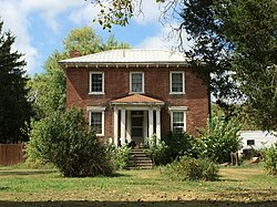
Gower House (c. 1830s)
USA West Virginia location map.svg
Red pog.svg
Donaldson
Usa edcp location map.svg
Red pog.svg
Donaldson
Coordinates: 39°29′51″N78°39′16″W / 39.49750°N 78.65444°W / 39.49750; -78.65444 Coordinates: 39°29′51″N78°39′16″W / 39.49750°N 78.65444°W / 39.49750; -78.65444
Country United States
State West Virginia
County Hampshire
Time zone Eastern (EST) (UTC-5)
  Summer (DST) EDT (UTC-4)
GNIS feature ID 1554318 [1]

Donaldson is an unincorporated community in Hampshire County in the U.S. state of West Virginia. It is located in Green Spring Valley on Green Spring Road (West Virginia Secondary Route 1) between Green Spring and Springfield. Donaldson was once a thriving railroad community along the South Branch Valley Railroad with its own school and post office [2] in operation.

Unincorporated area Region of land not governed by own local government

In law, an unincorporated area is a region of land that is not governed by a local municipal corporation; similarly an unincorporated community is a settlement that is not governed by its own local municipal corporation, but rather is administered as part of larger administrative divisions, such as a township, parish, borough, county, city, canton, state, province or country. Occasionally, municipalities dissolve or disincorporate, which may happen if they become fiscally insolvent, and services become the responsibility of a higher administration. Widespread unincorporated communities and areas are a distinguishing feature of the United States and Canada. In most other countries of the world, there are either no unincorporated areas at all, or these are very rare; typically remote, outlying, sparsely populated or uninhabited areas.

Hampshire County, West Virginia County in the United States

Hampshire County is a county in the U.S. state of West Virginia. As of the 2010 census, the population was 23,964. Its county seat is Romney, West Virginia's oldest town (1762). The county was created by the Virginia General Assembly in 1754, from parts of Frederick and Augusta Counties (Virginia) and is the state's oldest county. The county lies in both West Virginia's Eastern Panhandle and Potomac Highlands regions.

U.S. state constituent political entity of the United States

In the United States, a state is a constituent political entity, of which there are currently 50. Bound together in a political union, each state holds governmental jurisdiction over a separate and defined geographic territory and shares its sovereignty with the federal government. Due to this shared sovereignty, Americans are citizens both of the federal republic and of the state in which they reside. State citizenship and residency are flexible, and no government approval is required to move between states, except for persons restricted by certain types of court orders. Four states use the term commonwealth rather than state in their full official names.

Related Research Articles

Greenbrier River river in the United States of America

The Greenbrier River is a tributary of the New River, 162 miles (261 km) long, in southeastern West Virginia, in the United States. Via the New, Kanawha and Ohio rivers, it is part of the watershed of the Mississippi River, draining an area of 1,656 square miles (4,290 km2). It is one of the longest rivers in West Virginia.

Springfield, West Virginia Census-designated place in West Virginia, United States

Springfield is a census-designated place (CDP) in northwestern Hampshire County in the U.S. state of West Virginia. As of the 2010 census, Springfield had a population of 477. Springfield is located north of Romney along West Virginia Route 28 at its junction with Green Spring Road and Springfield Pike. It is currently considering incorporation.

Green Spring, West Virginia Census-designated place in West Virginia, United States

Green Spring is a census-designated place (CDP) and railroad town in Hampshire County, West Virginia, United States. As of the 2010 census, its population was 218. Green Spring is located north of Springfield on Green Spring Road near the confluence of the North and South Branches of the Potomac River. Green Spring is also the location of the South Branch Valley Railroad's terminus with the old Baltimore & Ohio Railroad mainline. Green Spring is the site of a one-lane low-water toll bridge that connects Green Spring Road to Maryland Route 51 in Oldtown, Allegany County, Maryland. This bridge is one of only 17 privately owned toll bridges in the United States. The toll for the bridge is currently US$1.50.

Sector, West Virginia Unincorporated community in West Virginia, United States

Sector is an unincorporated community in Hampshire County in the U.S. state of West Virginia. It is located along the west bank of the South Branch Potomac River on Fleming-Sector Road across the river from the community of Glebe.

Sedan, West Virginia Unincorporated community in West Virginia, United States

Sedan is an unincorporated community in Hampshire County in the U.S. state of West Virginia. Sedan is located between Hanging Rock and Delray on Delray Road in the North River Valley. The community was named for the Battle of Sedan, shortly after the battle was fought during the Franco-Prussian War on September 1, 1870. A post office operated in Sedan from 1871 to 1935.

Little Cacapon, West Virginia Unincorporated community in West Virginia, United States

Little Cacapon is an unincorporated community in Hampshire County in the U.S. state of West Virginia. Little Cacapon is located at the mouth of the Little Cacapon River on the Potomac, east of Okonoko. Okonoko-Little Cacapon Road and Spring Gap-Neals Run Road converge south of Little Cacapon. Because of its key location at the mouth of the Little Cacapon and on the Baltimore and Ohio Railroad, Little Cacapon played important roles in both the French and Indian and American Civil Wars. Generally pronounced kə-KAY-pən. Sometimes, despite the current spelling of the word some locals say KAY-pən.

Capon Lake, West Virginia Unincorporated community in West Virginia, United States

Capon Lake is an unincorporated community in Hampshire County of West Virginia's Eastern Panhandle region. Capon Lake is situated between Yellow Spring and Intermont at the junction of West Virginia Route 259 and Capon Springs Road along the Cacapon River. Capon Springs Run empties into the Cacapon here across from the old Capon Lake Whipple Truss Bridge. Capon Lake takes its name from the Cacapon River's lake-like characteristics there. It was a popular picnic spot for tourists and travelers on the Winchester and Western Railroad.

Intermont, West Virginia Unincorporated community in West Virginia, United States

Intermont is an unincorporated community in Hampshire County, West Virginia, United States located along West Virginia Route 259 on the Cacapon River. It was originally known as Mutton Run until 1920 when its name was changed to Intermont. Because of Mutton Run's location on the Winchester and Western Railroad, it may have been renamed after the Intermountain Construction Company that completed the railroad from Winchester to Wardensville. Their post office is closed.

Vanderlip, West Virginia Unincorporated community in West Virginia, United States

Vanderlip is an unincorporated community in Hampshire County in the U.S. state of West Virginia. Vanderlip is located west of Romney along the Northwestern Turnpike and the South Branch Valley Railroad. At times the community was referred to as West Romney Station, while its post office used the name Vanderlip, after a Baltimore and Ohio Railroad executive. The "heart" of Vanderlip is centered between Vanderlip Drive and Ozark Hill Road.

Rada, West Virginia Unincorporated community in West Virginia, United States

Rada is an unincorporated community in Hampshire County in the U.S. state of West Virginia. Rada is located on U.S. Highway 220/West Virginia Route 28 between Junction and Purgitsville in southwest Hampshire County along Mill Creek. It lies at an intersection of US 220/WV 28 with Rada Road.

Bubbling Spring, West Virginia Unincorporated community in West Virginia, United States

Bubbling Spring is an unincorporated community in Hampshire County in the U.S. state of West Virginia. Bubbling Spring is situated on Cacapon River Road along the Cacapon River south of Capon Bridge and north of Hooks Mills. It takes its name from the Bubbling Spring on the Cacapon there. Bubbling Spring has been known as Bubbling Spring Camps, Cacapon Bubbling Spring Camps, and Crystal Spring.

Capon Springs Station, West Virginia Unincorporated community in West Virginia, United States

Capon Springs Station was an unincorporated community hamlet in Hampshire County in the U.S. state of West Virginia centered on a station on the Winchester and Western Railroad. Located along Capon Springs Road where Dry Run meets Capon Springs Run on the western end of Middle Ridge, Capon Springs Station served as a stop for guests at the Capon Springs Resort in Capon Springs and people picnicking at Capon Lake on the Cacapon River.

Millen, West Virginia Unincorporated community in West Virginia, United States

Millen is an unincorporated community in Hampshire County, West Virginia, United States between Donaldson and Green Spring on Green Spring Road and the South Branch Valley Railroad. Millen is nestled in Green Spring Valley along Green Spring Run between Green Spring Ridge and Valley Mountain.

Pancake, West Virginia Unincorporated community in West Virginia, United States

Pancake is an unincorporated community in Hampshire County in the U.S. state of West Virginia. Pancake is located on Pancake Road, once connecting to South Branch River Road across the South Branch Potomac River. Pancake was once a stop along the South Branch Valley Railroad and is named for the Pancake family in the immediate area. The Pancake Post Office has been closed.

Woodrow, Hampshire and Morgan Counties, West Virginia Unincorporated community in West Virginia, United States

Woodrow is an unincorporated community that lies south of Paw Paw along West Virginia Route 9 in both Hampshire and Morgan Counties in West Virginia's Eastern Panhandle. Woodrow lies on the eastern flanks of Spring Gap Mountain with Sideling Hill to its east. Woodrow Union Church has served the community since the late 19th century.

Shiloh, Hampshire County, West Virginia Unincorporated community in West Virginia, United States

Shiloh is an unincorporated community in Hampshire County in the U.S. state of West Virginia. Shiloh is located on Gore Road near the Virginia line. Shiloh was once a stop on the old Winchester and Western Railroad. The community was named for Shiloh, a site mentioned in the Hebrew Bible that contained the Ark of the Covenant.

Green Spring Run is an 8.9-mile-long (14.3 km) tributary stream of the North Branch Potomac River in Hampshire County in the U.S. state of West Virginia. Green Spring Run rises in Greenwood Hollow north of Springfield and meanders northeast through Green Spring Valley. The South Branch Valley Railroad and Green Spring Road run parallel to the stream. It runs through the community of Green Spring, from which the stream takes its name. From Green Spring, Green Spring Run flows east where it reaches its confluence with the North Branch Potomac shortly before the North Branch joins with the South Branch Potomac River to form the Potomac River.

Ridgedale, Hampshire County, West Virginia Unincorporated community in West Virginia, United States

Ridgedale is an unincorporated community in Hampshire County in the U.S. state of West Virginia. It is located within a horsehoe bend in the South Branch Potomac River between the communities of Blues Beach and Wappocomo. Ridgedale is named for the recently restored 1835 plantation built by George W. Washington, also known as Washington Bottom Farm. Washington's plantation obtained its name due to its location at the foot of Mill Creek Ridge at its northernmost extent. Ridgedale is located off the South Branch Valley Railroad and is accessible from West Virginia Route 28 by way of Washington Road. Ridgedale once had a post office and a school in operation there. Today, Ridgedale consists of the old Washington farm and a number of summer camps, cabins, and vacation homes on the South Branch.

Wickham, Hampshire County, West Virginia Unincorporated community in West Virginia, United States

Wickham is an extinct unincorporated community in Hampshire County in the U.S. state of West Virginia. It originally developed as a stop on the South Branch Valley Railroad in the Trough. Wickham is located within a gap in Mill Creek Mountain on the South Branch Potomac River. One white clapboard structure remains of the community.

Valley, West Virginia Unincorporated community in West Virginia, United States

Valley was a populated place and post office on the South Branch line of the Baltimore and Ohio Railroad in the U.S. state of West Virginia. It was centered near the intersection of West Sioux Lane and Depot Valley Road, now located within the present-day corporate boundaries of Romney. Valley developed in 1884 following the completion of the South Branch line when the rail line's original southern terminus and corresponding Romney Depot were built there. The United States Post Office Department established a post office at Valley on May 19, 1928, remaining in operation until its disestablishment on June 15, 1937. Following the closure of Valley's post office, its mail was routed through the post office in Romney.

References