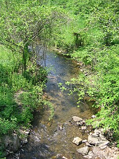
The Cacapon River, located in the Appalachian Mountains of West Virginia's Eastern Panhandle region, is an 81.0-mile-long (130.4 km) river known for its fishing, boating, wildlife, and scenery. As part of the Potomac River watershed, it is an American Heritage River.

Sleepy Creek is a 44.0-mile-long (70.8 km) tributary of the Potomac River in the United States, belonging to the Chesapeake Bay's watershed. The stream rises in Frederick County, Virginia, and flows through Morgan County, West Virginia before joining the Potomac near the community of Sleepy Creek.

Dillons Run is a 12.9-mile-long (20.8 km) tributary stream of the Cacapon River, belonging to the Potomac River and Chesapeake Bay watersheds. The stream is located in Hampshire County in the U.S. state of West Virginia's Eastern Panhandle.
Cooper Mountain runs southwest northeast through Hampshire County in West Virginia's Eastern Panhandle, rising to its greatest elevation of 2,028 feet (618 m) above sea-level at Bens Knob. The mountain's other knob, Butchers Knob, has an elevation of 1,783 feet (543 m). Cooper Mountain is flanked to its west by North River Mountain and to its east by Parks Valley and Dillons Run. The Northwestern Turnpike crosses Cooper Mountain at Loom between Hanging Rock and Capon Bridge. Tourists and travelers on U.S. Route 50 pull off at the Cooper Mountain overlook for the views over Parks Valley, Capon Bridge, and the ridges of Virginia.
The AA Northwestern District is a high school conference in the state of Virginia that includes Frederick County and Warren County. The Northwestern District member schools compete in Region II with the schools from the AA Dulles District, AA Jefferson District, and AA Evergreen District.
Cacapon is a term of Native American origin that means "medicine waters." Most placenames named Cacapon or the variation of Capon are named for the Cacapon River in West Virginia's Eastern Panhandle, United States.

Dillons Run was an unincorporated community in Hampshire County, West Virginia, United States. It is located at the intersection of Dillons Run Road and Haines Road along Dillons Run stream from which it takes its name. Dillons Run no longer has its own post office in operation. It was originally known as Luptons Mill.

Big Run is a 4.4-mile-long (7.1 km) tributary stream of the South Branch Potomac River, belonging to the Potomac River and Chesapeake Bay watersheds. Big Run flows through the city of Romney and the campus of the West Virginia Schools for the Deaf and Blind in Hampshire County, West Virginia. The stream is known by local residents as Town Run and Town Creek.

Millbrook is a suburb and former civil parish of Southampton. As the area developed, several settlements grew within the parish, some of them becoming parishes in their own right, thus reducing the extent of the Millbrook parish. As well as the Millbrook of today, the original Millbrook parish included Freemantle, Regents Park, and Redbridge. Some of these areas are still referred to as being part of Millbrook. The brook that Millbrook was named after is now known as Tanner's Brook.
Hampshire Rugby Football Union is the governing body for rugby union in the county of Hampshire, England. It represent clubs sides not just from Hampshire but also from the Isle of Wight and the Channel Islands, who take part in many of the competitions organized by the Hampshire RFU.

Bear Garden Mountain is a forested mountain ridge of the Ridge-and-valley Appalachians in Hampshire County, West Virginia and Frederick County, Virginia.
Schaffenaker Mountain is a forested mountain ridge of the Ridge-and-valley Appalachians in Hampshire County in the U.S. state of West Virginia. The ridge runs southwest northeast between Edwards Run and Dillons Run. Schaffenaker Mountain takes its name from the Schaffenaker family that settled in the immediate area. The Northwestern Turnpike climbs Schaffenaker Mountain to the west of the town of Capon Bridge offering a bird's eye view of the community and of the Cacapon River. Until recently, the mountain had remained mostly undeveloped but its views and proximity to Capon Bridge have made it a prime location for real estate development by companies such as the North American Land Corporation.

The North River is a tributary of the Cacapon River, belonging to the Potomac River and Chesapeake Bay watersheds. The river is located in Hampshire and Hardy counties in the U.S. state of West Virginia's Eastern Panhandle. The mouth of the North River into the Cacapon is located at Forks of Cacapon. From its headwaters to its mouth, the North River spans 52.4 miles (84.3 km) in length.
Mill Run is a 9.1-mile-long (14.6 km) tributary stream of the South Branch Potomac River, belonging to the Potomac River and Chesapeake Bay watersheds. The stream is located in Hampshire County in the Eastern Panhandle of the U.S. state of West Virginia. Mill Run rises on Nathaniel Mountain and flows northeast, then northwest into the South Branch south of Romney near Hampshire Park on South Branch River Road.
John Rinehart Blue was a Democratic member of the West Virginia House of Delegates representing Hampshire County, West Virginia from 1953 through 1959. Blue was also a prominent schoolteacher, variety store owner, and community leader in his hometown of Romney.


