
Hampshire County is a county in the U.S. state of West Virginia. As of the 2010 census, the population was 23,964. Its county seat is Romney, West Virginia's oldest town (1762). The county was created by the Virginia General Assembly in 1754, from parts of Frederick and Augusta Counties (Virginia) and is the state's oldest county. The county lies in both West Virginia's Eastern Panhandle and Potomac Highlands regions.

Rockingham County is a county located in the U.S. state of Virginia. As of the 2010 census, the population was 76,314. Its county seat is the independent city of Harrisonburg.

The Blue Ridge Mountains are a physiographic province of the larger Appalachian Mountains range. The mountain range is located in the eastern United States, and extends 550 miles southwest from southern Pennsylvania through Maryland, West Virginia, Virginia, North Carolina, South Carolina, Tennessee, and Georgia. This province consists of northern and southern physiographic regions, which divide near the Roanoke River gap. To the west of the Blue Ridge, between it and the bulk of the Appalachians, lies the Great Appalachian Valley, bordered on the west by the Ridge and Valley province of the Appalachian range.

The South Branch Potomac River has its headwaters in northwestern Highland County, Virginia near Hightown along the eastern edge of the Allegheny Front. After a river distance of 139 miles (224 km), the mouth of the South Branch lies east of Green Spring in Hampshire County, West Virginia where it meets the North Branch Potomac River to form the Potomac.

The Cacapon River, located in the Appalachian Mountains of West Virginia's Eastern Panhandle region, is an 81.0-mile-long (130.4 km) river known for its fishing, boating, wildlife, and scenery. As part of the Potomac River watershed, it is an American Heritage River.

The Greenbrier River is a tributary of the New River, 162 miles (261 km) long, in southeastern West Virginia, in the United States. Via the New, Kanawha and Ohio rivers, it is part of the watershed of the Mississippi River, draining an area of 1,656 square miles (4,290 km2). It is one of the longest rivers in West Virginia.
The Northwestern Turnpike is a historic road in West Virginia, important for being historically one of the major roads crossing the Appalachians, financed by the Virginia Board of Public Works in the 1830s. In modern times, west of Winchester, Virginia, U.S. Route 50 follows the path of the Northwestern Turnpike into West Virginia, whose major Corridor D project follows the western section of the original Northwestern Turnpike.

Springfield is a census-designated place (CDP) in northwestern Hampshire County in the U.S. state of West Virginia. As of the 2010 census, Springfield had a population of 477. Springfield is located north of Romney along West Virginia Route 28 at its junction with Green Spring Road and Springfield Pike. It is currently considering incorporation.

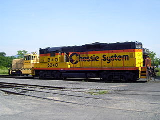
Green Spring is a census-designated place (CDP) and railroad town in Hampshire County, West Virginia, United States. As of the 2010 census, its population was 218. Green Spring is located north of Springfield on Green Spring Road near the confluence of the North and South Branches of the Potomac River. Green Spring is also the location of the South Branch Valley Railroad's terminus with the old Baltimore & Ohio Railroad mainline. Green Spring is the site of a one-lane low-water toll bridge that connects Green Spring Road to Maryland Route 51 in Oldtown, Allegany County, Maryland. This bridge is one of only 17 privately owned toll bridges in the United States. The toll for the bridge is currently US$1.50.
The South Branch Valley Railroad consists of a 52.4 mile (84.33 km) length of railroad in the U.S. state of West Virginia extending north along the South Branch Potomac River from Petersburg to the CSXT mainline at Green Spring adjacent to the Potomac River. At Green Spring, the CSXT mainline connects the SBVR to Cumberland, Maryland to the west and Martinsburg, West Virginia to the east. SBVR has been owned and operated by the West Virginia State Rail Authority (SRA) since it was sold by the Baltimore & Ohio Railroad on October 11, 1978. Upon purchasing the B&O's South Branch line, West Virginia became the first state in the United States to both own and operate a commercial freight railroad. In 1985, major flooding of the South Branch Valley destroyed most of the rail line, including all three bridges that crossed the South Branch Potomac River. Despite talk of shutting down the railroad after the flood, reconstruction began two years later.

Rock Gap is an unincorporated community along Valley Road in Morgan County, West Virginia, United States. It is located between Omps to its south and Berkeley Springs to its north. Situated between Warm Springs Ridge to its west and Timber Ridge to its east, Rock Gap takes its name from the "Rock Gap" in Warm Spring Ridge, carved out by Rock Gap Run, a tributary stream of Sleepy Creek.

Donaldson is an unincorporated community in Hampshire County in the U.S. state of West Virginia. It is located in Green Spring Valley on Green Spring Road between Green Spring and Springfield. Donaldson was once a thriving railroad community along the South Branch Valley Railroad with its own school and post office in operation.

White Hall is an unincorporated farming community in northern Frederick County, Virginia, established in the late 1810s and located near the crossroads of Apple Pie Ridge Road with Green Spring and White Hall Roads, astride Apple Pie Ridge.
Green Spring Run is an 8.9-mile-long (14.3 km) tributary stream of the North Branch Potomac River in Hampshire County in the U.S. state of West Virginia. Green Spring Run rises in Greenwood Hollow north of Springfield and meanders northeast through Green Spring Valley. The South Branch Valley Railroad and Green Spring Road run parallel to the stream. It runs through the community of Green Spring, from which the stream takes its name. From Green Spring, Green Spring Run flows east where it reaches its confluence with the North Branch Potomac shortly before the North Branch joins with the South Branch Potomac River to form the Potomac River.

Canaan Valley Resort State Park is a state park in the eastern United States, within Canaan Valley in Tucker County, West Virginia. Located in the highest valley east of the Mississippi River, the park contains the second-largest inland wetland area in the United States. The valley featured the first commercial ski development in West Virginia.

North Mountain is a mountain ridge within the Ridge-and-valley Appalachians in the U.S. states of Virginia and West Virginia.
State Route 82 (SR 82) is a primary state highway in central Russell County, Virginia, United States. Known as Cleveland Road for most of its length, the route runs 6.84 miles (11.01 km) from SR 600 (SR 600) and SR 661 (SR 661) in Cleveland to U.S. Route 19 Business in Lebanon, providing a mountain crossing connecting the two towns.
Green Sulphur Springs is an unincorporated community in Summers County, West Virginia, United States. It lies near Interstate 64 to the northeast of the city of Hinton, the county seat of Summers County. Its elevation is 1,552 feet. Green Sulphur Springs had a post office, with the ZIP code of 25966, until it closed on February 29, 1992.
Moorefield and North Branch Turnpike was a turnpike in the U.S. state of Virginia built to facilitate travel and commerce between the Baltimore and Ohio Railroad at Green Spring on the North Branch Potomac River and Moorefield. Today, Green Spring Road, Harriott-Wappocomo Road, and West Virginia Route 28 encompass most of the Moorefield and North Branch Turnpike's original route.

The Laurel Fork is a 15.7-mile-long (25.3 km) stream in Virginia and West Virginia, United States. The stream flows north from Highland County, Virginia, where its source and the majority of its length is located, to its mouth in Pendleton County, West Virginia. Laurel Fork is a tributary to the North Fork South Branch Potomac River, making it a part of the Potomac River watershed. The area surrounding Laurel Fork is home to several plant and animal species found nowhere else in Virginia, and is a prime example of a northern boreal forest in the state.


