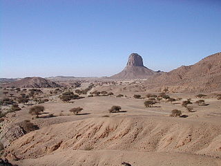
The West Saharan montane xeric woodlands is an ecoregion that extends across several highland regions in the Sahara. Surrounded at lower elevations by the largely barren Sahara, the West Saharan montane xeric woodlands are isolated refuges of plants and animals that can survive in the higher humidity and lower temperatures of the highlands.

The Zagros Mountains forest steppe is a temperate broadleaf and mixed forests ecoregion in Western Asia. The ecoregion extends along the Zagros Mountains, stretching from eastern Turkey and northern Iraq to southern Iran.

The Eastern Mediterranean conifer-sclerophyllous-forests, also known as the Eastern Mediterranean conifer-forests, is an ecoregion in the eastern Mediterranean Basin. It covers portions of Turkey, Syria, Iraq, Lebanon, Israel, Palestinian territories, Jordan, and Saudi Arabia.
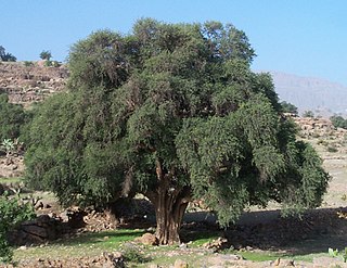
The Mediterranean Acacia–Argania dry woodlands and succulent thickets is a Mediterranean forests, woodlands, and scrub ecoregion in North Africa centered mainly on Morocco but also including northwestern Western Sahara and the eastern Canary Islands.

The North Saharan steppe and woodlands is a desert ecoregion, in the deserts and xeric shrublands biome, that forms the northern edge of the Sahara. It extends east and west across Northern Africa, south of the Mediterranean dry woodlands and steppe ecoregion of the Maghreb and Cyrenaica, which is part of the Mediterranean forests, woodlands, and scrub biome. Winter rains sustain shrublands and dry woodlands that form an ecotone between the Mediterranean climate regions to the north and the hyper-arid Sahara Desert ecoregion to the south.

The Mediterranean woodlands and forests is an ecoregion in the coastal plains, hills, and mountains bordering the Mediterranean Sea and Atlantic Ocean in North Africa. It has a Mediterranean climate, and is in the Mediterranean forests, woodlands, and scrub biome.

The Illyrian deciduous forests is a terrestrial ecoregion in southern Europe, which extends along the eastern coast of the Adriatic Sea. It belongs to the Mediterranean forests, woodlands, and scrub biome, and is in the Palearctic realm.

The Italian sclerophyllous and deciduous forests ecoregion, part of the Mediterranean forests, woodlands, and scrub biome, is in Italy. The ecoregion covers most of the Italian Peninsula and includes both evergreen and deciduous forests.

The Tyrrhenian-Adriatic sclerophyllous and mixed forests is an ecoregion in southern Italy, Sicily, Sardinia, Corsica, the Dalmatian Islands of Croatia, and Malta.

The Eastern Anatolian montane steppe is a temperate grasslands, savannas, and shrublands ecoregion. It is located in the Armenian Highlands, covering parts of eastern Turkey, Armenia, Azerbaijan, southern Georgia, and northwestern Iran.

The Iberian sclerophyllous and semi-deciduous forests is a Mediterranean forests, woodlands, and scrub ecoregion in southwestern Europe. It occupies the interior valleys and plateaus of the Iberian Peninsula. The ecoregion lies mostly in Spain, and includes some portions of eastern Portugal.

The Northeastern Spain and Southern France Mediterranean forests is a Mediterranean forests, woodlands, and scrub ecoregion in southwestern Europe. It occupies the Mediterranean coastal region of northeastern Spain, Southern France, the Balearic Islands and a small part of Italy.
The Southeastern Iberian shrubs and woodlands is a Mediterranean forests, woodlands, and scrub ecoregion in southwestern Europe. It lies in southeastern coastal Spain, along the Mediterranean Sea.
The Gissaro-Alai open woodlands ecoregion covers the western foothills winding around two western offshoots of the Tian Shan Mountains in western Tajikistan, and parts of eastern Uzbekistan and western Kyrgyzstan, in Central Asia. The woodlands are typically of Juniper trees and shrubs, fitting the altitude zone situated between the desert valley floor, and the tree line, above which the mountain ridges are glaciated and barren.
The Azerbaijan shrub desert and steppe is a deserts and xeric shrublands ecoregion in western Asia. It lies in the lowlands west of the Caspian Sea, and covers portions of Azerbaijan, Georgia, and Iran.

The Central Afghan Mountains xeric woodlands ecoregion covers the xeric (dry) eastern and southern slopes of the central mountain range of Afghanistan, between the sandy desert to the south and the alpine meadows in the higher, wetter region to the north. Despite the 'woodlands' in the ecoregion name, very little of the territory is forested – less than 1% – but is instead sparse vegetation or herbaceous cover.

The Paropamisus xeric woodlands ecoregion covers the portion of northeastern Afghanistan north of the central mountain range and the Hindu Kush Mountains. The name is derived from the Old Persian name for the region, Parupraesanna. While there are low canopy woodlands in the northeast of the ecorgegion, most of the territory is desert or xeric (dry) scrubland.
The Mesopotamian shrub desert is a deserts and xeric shrublands ecoregion in Western Asia. It extends across portions of Israel, Jordan, Syria, Iraq, and Iran.

The Baluchistan xeric woodlands ecoregion covers the middle elevations of a series of mountain ranges of western Pakistan and northeastern Afghanistan, reaching 1,200 kilometres (750 mi) from the Arabian Sea in the south to the Hindu Kush Mountains and the Himalayas in the north. The characteristic vegetation is xeric (dry) woodlands of shrubs and herbaceous cover. The region has rich biodiversity but relatively few endemic species.

The Nile Delta flooded savanna, ecoregion covers both the Nile Delta proper, where the Nile River enters the Mediterranean Sea, as well as the river floodplains of the Nile 1,100 kilometres (680 mi) up-river to the Aswan Dam. Since the Aswan Dam was completed in the 1970s, the Nile on this stretch has not been subject to annual flooding, leading the loss of much of the papyrus sedge swamps and other marshes along the river.


