
The Shiawassee National Wildlife Refuge is a 9,870.35 acres (39.9439 km2) National Wildlife Refuge in Saginaw County managed by the United States Fish and Wildlife Service. It is located in the central portion of the lower peninsula of the U.S. state of Michigan, approximately 25 miles (40 km) south of the Saginaw Bay in Lake Huron and five miles (8 km) south of the city of Saginaw in the county's Spaulding and James townships. It was established in 1953 to provide habitat for migratory waterfowl.

Missisquoi National Wildlife Refuge is a National Wildlife Refuge in the U.S. state of Vermont located on the eastern shore of Lake Champlain and the southern side of Missisquoi Bay. The refuge is in Franklin County in the northwest corner of the state near the International Boundary with Canada.

The Great Meadows National Wildlife Refuge is a 12-mile-long (19 km) river wetlands conservation area, in two major parcels, stretching from the towns of Billerica, Massachusetts (downstream) to Wayland, Massachusetts (upstream), along the Concord River and Sudbury River.

The Detroit River International Wildlife Refuge is the only international wildlife refuge in North America. Established in 2001 and managed jointly by the United States Fish and Wildlife Service and the Canadian Wildlife Service, it is located in a major metropolitan area. The Detroit River International Wildlife Refuge is one of over 540 National Wildlife Refuges managed by the U.S. Fish and Wildlife Service within the Department of the Interior. It occupies 7.88 square miles (20.41 km2) of scattered property but has drawn boundaries for further expansion.

The Upper Mississippi River National Wildlife and Fish Refuge is a 240,000-acre (970 km2), 261-mile long (420 km) National Wildlife Refuge located in and along the Upper Mississippi River. It runs from Wabasha, Minnesota in the north to Rock Island, Illinois in the south.

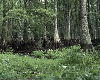
The Okefenokee National Wildlife Refuge is a 402,000‑acre (1,627 km2) National Wildlife Refuge located in Charlton, Ware, and Clinch Counties of Georgia, and Baker County in Florida, United States. The refuge is administered from offices in Folkston, Georgia. The refuge was established in 1937 to protect a majority of the 438,000 acre (1,772 km2) Okefenokee Swamp. Though often translated as "land of trembling earth", the name "Okefenokee" is likely derived from Hitchiti oki fanôːki "bubbling water".

The Chautauqua National Wildlife Refuge is located on the Illinois River in Mason County northeast of Havana, Illinois. It is managed by the U.S. Fish and Wildlife Service as one of the four Illinois River National Wildlife and Fish Refuges.

The National Wildlife Refuge System in the United States has a long and distinguished history.

The Tualatin River National Wildlife Refuge is a 1,856 acres (751 ha) wetlands and lowlands sanctuary in the northwestern part of the U.S. state of Oregon. Established in 1992 and opened to the public in 2006, it is managed by the United States Fish and Wildlife Service. Located in southeastern Washington County, 15 miles (24 km) southwest of Portland, the refuge is bordered by Sherwood, Tualatin and Tigard. A newer area, extending into northern Yamhill County, is located further west near the city of Gaston surrounding the former Wapato Lake.
The Emiquon National Wildlife Refuge is a 11,122-acre (45.01 km2) wetland wildlife refuge located in Waterford Township in Fulton County, Illinois across the Illinois River from the town of Havana. Only 3,000 acres (12 km2) are currently managed by the U.S. Fish and Wildlife Service as part of the Illinois River National Wildlife and Fish Refuges Complex. It is in the Central forest-grasslands transition ecoregion.

The Pocosin Lakes National Wildlife Refuge is located in North Carolina's Inner Banks on the Albemarle-Pamlico Peninsula in Hyde, Tyrrell, and Washington Counties, North Carolina. Its headquarters is located in Columbia.
Bayou Cocodrie National Wildlife Refuge was established in 1992 to protect some of the last remaining, least-disturbed bottomland hardwood forest tracts in the Lower Mississippi Valley. These wooded wetlands, oxbow lakes, brakes, sloughs, and bayous, are inhabited seasonally by over 150 species of migratory birds, including forest-breeding birds, water birds, and waterfowl. The 15,155-acre (61.33 km2) refuge is located in Concordia Parish, Louisiana, 10 miles (16 km) southwest of Vidalia, Louisiana. It is named for the state-designated scenic river which runs through its center.
Catahoula National Wildlife Refuge, located in east central Louisiana, United States, 12 miles (19 km) east of Jena, was established in 1958 as a wintering area for migratory waterfowl. The refuge contains 25,162 acres (101.83 km2) divided into two units. The 6,671-acre (27 km2) Headquarters Unit borders nine miles (14 km) of the northeast shore of Catahoula Lake, a 26,000-acre (110 km2) natural wetland renowned for its large concentrations of migratory waterfowl. The 18,491-acre (74.83 km2) Bushley Bayou Unit, located 8 miles (13 km) west of Jonesville, was established May 16, 2001. This acquisition was made possible through a partnership agreement between The Conservation Fund, American Electric Power, and the Fish and Wildlife Service. The habitat found at the refuge is primarily lowland hardwood forest subject to seasonal backwater flooding from the Ouachita, and Red Rivers. The refuge is located in the Mississippi Alluvial Plain, Southern Backswamps ecoregion.
Lake Ophelia National Wildlife Refuge was established in 1988 to protect the Mississippi/Red River floodplain ecosystem. The refuge is located in Avoyelles Parish, Louisiana, east central Louisiana. The refuge is named for its most prominent water body, the 350-acre (1.4 km2) Lake Ophelia that was at one time a channel of the nearby Red River of the South.

Wapato Lake is a restored historic lake located in what became parts of Washington County and Yamhill County in the U.S. state of Oregon. The area was sometimes known as Wapato Lake Bed and Wapato Flat. The lake is located about a half mile east of Gaston at 55 metres (180 ft) elevation. The lake bed soils contain a layer of organic peat that once supported a wetland community dominated by the wapato plant, Sagittaria latifolia, particularly in the upper marsh areas. Wapato plants were reintroduced to the restored lake by tribal people from the Confederated Tribes of the Grand Ronde Community in preparation for the opening of the Wapato Lake National Wildlife Refuge in March 2023.
Crane Meadows National Wildlife Refuge, located in central Minnesota, USA, was established in 1992 to preserve a large, natural wetland complex. It is an essential stop for many species of migrating birds. Located within a large watershed that includes Rice, Skunk and Mud Lakes, Platte and Skunk Rivers, Rice and Buckman Creeks, and sedge meadow wetlands, it harbors one of the largest nesting populations of greater sandhill cranes in Minnesota. Habitats include native tallgrass prairie, oak savanna and wetlands with wild rice stands. With a total authorized acquisition boundary of 13,540 acres (54.8 km2) encompassing this important wetland complex and adjacent uplands, the refuge exists as scattered parcels totaling about 2,000 acres (8.1 km2). Existing ownership lies in Little Falls and Agram townships in Morrison County.

The Summer Lake Wildlife Area is a 29.6-square-mile (77 km2) wildlife refuge located on the northwestern edge of the Great Basin drainage in south-central Oregon. It is administered by the Oregon Department of Fish and Wildlife. The refuge is an important stop for waterfowl traveling along the Pacific Flyway during their spring and fall migrations. The Summer Lake Wildlife Area also provides habitat for shorebirds and other bird species as well as wide variety of mammals and several fish species. The Ana River supplies the water for the refuge wetlands.
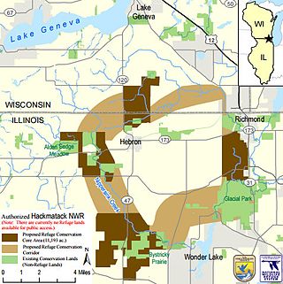
The Hackmatack National Wildlife Refuge is a United States national wildlife refuge that will include noncontiguous properties, especially tallgrass prairie patches, wetland properties, and oak savanna parcels, located in the northwestern region of the Chicago metropolitan area and the southern part of the Milwaukee area. The refuge's boundaries encompass parts of McHenry County, Illinois, and Walworth County, Wisconsin. The refuge will be operated by the United States Fish and Wildlife Service, known as USFWS. 85 percent of the refuge will be in Illinois, and 15 percent in Wisconsin.
Meredosia Lake is a riparian lake that forms part of the valley of the Illinois River. It is located in Cass and Morgan Counties, Illinois. Much of the floodplain isthmus between Lake Meredosia and the river is known as Meredosia Island, and much of the quasi-island and associated lakebed are part of the Meredosia National Wildlife Refuge.
