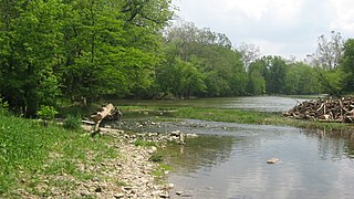
The Calumet River is a system of heavily industrialized rivers and canals in the region between the south side of Chicago, Illinois, and the city of Gary, Indiana. Historically, the Little Calumet River and the Grand Calumet River were one, the former flowing west from Indiana into Illinois, then turning back east to its mouth at Lake Michigan at Marquette Park in Gary. Now the system is part of the Chicago Area Waterway System and through the use of locks flows away from Lake Michigan to the Cal-Sag Channel.

The Rock River is a tributary of the Mississippi River, approximately 299 miles (481 km) long, in the U.S. states of Wisconsin and Illinois. The river was known as the Sinnissippi to Sauk and Meskwaki peoples; the name means "rocky waters".

The Pecatonica River is a tributary of the Rock River, 194 miles (312 km) long, in southern Wisconsin and northern Illinois in the United States.

The Current River forms in the southeastern portion of the Ozarks of Missouri and becomes a 7th order stream as it flows southeasterly out of the Ozarks into northeastern Arkansas where it becomes a tributary of the Black River, which is a tributary of the White River, a tributary of the Mississippi River. The Current River is roughly 184 miles (296 km) long and drains about 2,641 square miles (6,840 km2) of land mostly in Missouri and a small portion of land in northeastern Arkansas. The headwaters of the Current River are nearly 900 feet (270 m) above sea level, while the mouth of the river lies around 280 feet (85 m) above sea level. The basin drains a rural area that is dominated by karst topography, underlain by dolomite and sandstone bedrock with a small area of igneous rock southeast of Eminence, Missouri. The annual daily mean discharge of the river near Doniphan, Missouri is 2,815 cubic feet (79.7 m3) per second. In 1964, over 134 mi (160 km) of the upper course of the river and its tributaries were federally protected as the Ozark National Scenic Riverways, the first national park in America to protect a river system.

The Kaskaskia River is a tributary of the Mississippi River, approximately 325 miles (523 km) long, in central and southern Illinois in the United States. The second largest river system within Illinois, it drains a rural area of farms, as well as rolling hills along river bottoms of hardwood forests in its lower reaches. The lower reaches of the river have been canalized to allow barge traffic. In 1819, Vandalia up the river in the interior of the then new state of Illinois was chosen as its capital, which it served as until 1839.
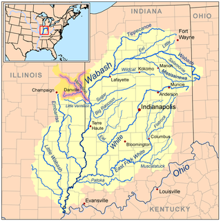
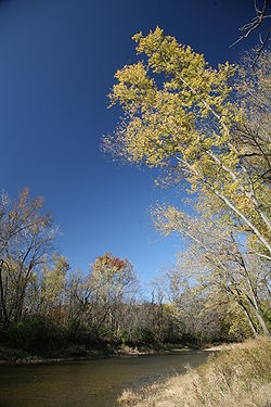
The Vermilion River is a tributary of the Wabash River in the states of Illinois and Indiana, United States.

Little Beaver Creek is a wild and scenic area in Ohio. The Little Beaver Creek watershed is located primarily in Columbiana County in eastern Ohio, and in portions of Carroll County, Mahoning County, and western Pennsylvania, draining approximately 605 mi² (1,567 km²), of which 503 mi² (1,303 km²) are in Ohio. The watershed in total size covers an area of approximately 510 square miles, with about 80% of this being situated in Ohio. The great majority of land within the watershed is privately owned. Within the watershed are roughly 808 miles of linear streams.

The Iroquois River is a 103-mile-long (166 km) tributary of the Kankakee River in the Central Corn Belt Plains of northwestern Indiana and northeastern Illinois in the United States. It was named for the Iroquois people. Via the Kankakee and Illinois rivers, it is part of the watershed of the Mississippi River.
The Mackinaw River is a 130-mile-long (210 km) tributary of the Illinois River in the U.S. state of Illinois. Its watershed covers approximately 1,136 square miles (3,000 km2), and contains some of the most productive agricultural land in the United States. The river itself maintains some of the highest quality streams in the state and provides habitat for 60-70 native fish species and 25-30 species of mussels. Its name, also spelled Mackinac, is derived from the Ojibwe word mikinaak meaning "turtle".

The Embarras River is a 195-mile-long (314 km) tributary of the Wabash River in southeastern Illinois in the United States. The waters of the Embarras reach the Gulf of Mexico via the Wabash, Ohio, and Mississippi Rivers. The river drains a watershed around 1,566,450 acres (6,339.2 km2) in an agricultural region. It arises near Champaign-Urbana and flows south to near Vincennes, Indiana. The name comes from French explorers, who used the French word, embarras, for river navigation obstacles, blockages, and difficulties relating to logjams.
The Little River is a 22.6-mile-long (36.4 km) stream in Allen and Huntington counties in northeastern Indiana. A tributary of the Wabash River, it is sometimes called the "Little Wabash", which may cause it to be confused with the Little Wabash River of Illinois. The river drains an area of 287.9 square miles (746 km2).

Boneyard Creek is a 3.3-mile-long (5.3 km) waterway that drains much of the cities of Champaign and Urbana, Illinois, United States. It is a tributary of the Saline Branch of the Salt Fork Vermilion River, which is a tributary of the south-flowing Vermilion River and the Wabash River. The creek flows through the northern sections of the campus of the University of Illinois Urbana-Champaign. The newsletter of the university's ACM chapter is Banks of the Boneyard, named after the creek.

The Vermilion River is a 74.8-mile-long (120.4 km) tributary of the Illinois River in the state of Illinois, United States. The river flows north, in contrast to a second Vermilion River in Illinois, which flows south to the Wabash River. The Illinois and Wabash rivers each have a tributary named the Little Vermilion River as well.
The Salt Fork is a tributary of the Vermilion River located in the Central Corn Belt Plains of Illinois.
The Mazon River or Mazon Creek, is a tributary of the Illinois River in the United States. The confluence is near Morris, Illinois.
Henderson Creek is a 64.6-mile-long (104.0 km) tributary of the Mississippi River, which it joins in Henderson County, Illinois, near the villages of Gladstone and Oquawka.
Macoupin Creek is a 99.7-mile-long (160.5 km) tributary of the Illinois River, which it joins near the village of Hardin, Illinois.
The West Okaw River is a tributary of the Kaskaskia River, which it joins in Moultrie County, Illinois. The West Okaw forms an arm of Lake Shelbyville where the natural rivers used to meet.
Salt Creek is a major tributary to the Sangamon River, which it joins at the boundary between Mason and Menard County, Illinois. There are at least two other Salt Creeks in Illinois, Salt Creek, and in Effingham County, Illinois.
The Saline Branch, or Saline Branch Ditch, is a tributary of the Vermilion River in east central Illinois. It drains a parcel of east-central Champaign County, including most of the city of Urbana, Illinois and the University of Illinois campus within Urbana.