
Calhoun County is a county in the U.S. state of Illinois. As of the 2020 census, the population was 4,437, making it Illinois’ third-least populous county. Its county seat and biggest community is Hardin, with a population of 801. Its smallest incorporated community is Hamburg, with a population of 99. Calhoun County is at the tip of the peninsula formed by the courses of the Mississippi and Illinois rivers above their confluence and is almost completely surrounded by water. Calhoun County is sparsely populated; it has just five municipalities, all of them villages.
The Wapanocca National Wildlife Refuge is a 5,484 acre (22 km2) wildlife refuge in Crittenden County, Arkansas, managed by the United States Fish and Wildlife Service.

The Alamosa National Wildlife Refuge is an 11,169-acre (4,520 ha) United States National Wildlife Refuge located in southern Colorado. The site is located in the San Luis Valley along the east side of the Rio Grande approximately 8 miles (13 km) southeast of Alamosa primarily in southeastern Alamosa County, although very small parts extend into northeastern Conejos and western Costilla counties. It is managed by the United States Fish and Wildlife Service jointly with the Baca and Monte Vista National Wildlife Refuges. It was established in 1962 as a haven for migratory birds and other wildlife.

The Arapaho National Wildlife Refuge is a United States National Wildlife Refuge located in north-central Colorado. It is one of over 560 national wildlife refuges which manages and protects natural resources for future generations. The refuge is located in North Park in central Jackson County south of the town of Walden. The refuge was established in 1967 to furnish waterfowl with a suitable place to nest and rear their young. It was created in part to offset losses of nesting habitat in the prairie wetland region of the Midwest. It is located in the valley of the Illinois River, a tributary of the North Platte River. It is administered by the United States Fish and Wildlife Service.

Aransas National Wildlife Refuge is a 115,324-acre (466.7 km2) protected area situated on the southwest side of San Antonio Bay along the Gulf Coast of the U.S. state of Texas. It is located in parts of Aransas, Refugio, and Calhoun Counties. It is situated on the southwest side of the San Antonio Bay, formed by the mouth of the Guadalupe River. It also includes nearly the entirety of Matagorda Island, a 38-mile barrier island. The Aransas National Wildlife Refuge was established by Executive Order 7784 on 31 December 1937 by President Franklin D. Roosevelt as the Aransas Migratory Waterfowl Refuge as a refuge and breeding ground for migratory birds and other wildlife. Roosevelt issued a proclamation in 1940 changing the name to the Aransas National Wildlife Refuge.

Driftless Area National Wildlife Refuge is a United States National Wildlife Refuge in northeastern Iowa, southwestern Wisconsin and northwestern Illinois. It is a collection of non-contiguous parcels in the vicinity of the Upper Mississippi River National Wildlife and Fish Refuge.

The Upper Mississippi River National Wildlife and Fish Refuge is a 240,000-acre (970 km2), 261-mile long (420 km) National Wildlife Refuge located in and along the Upper Mississippi River. It runs from Wabasha, Minnesota in the north to Rock Island, Illinois in the south.

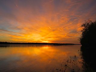
The Chautauqua National Wildlife Refuge is located on the Illinois River in Mason County northeast of Havana, Illinois. It is managed by the U.S. Fish and Wildlife Service as one of the four Illinois River National Wildlife and Fish Refuges.
Lower Hatchie National Wildlife Refuge, part of the U.S. National Wildlife Refuge system, is a 9,451-acre (38.25 km2) area of wetlands associated with the confluence of the Hatchie River and the Forked Deer River in West Tennessee near the confluence of the Hatchie River with the Mississippi River. Located in parts of southwestern Lauderdale and northern Tipton counties, it is a rich environment for both aquatic life and waterfowl.

William L. Finley National Wildlife Refuge is a natural area in the Willamette Valley in Oregon, United States. It was created to provide wintering habitat for dusky Canada geese. Unlike other Canada geese, dusky Canada geese have limited summer and winter ranges. They nest on Alaska's Copper River Delta and winter almost exclusively in the Willamette Valley. Habitat loss, predation, and hunting have caused a decrease in population.
Chickasaw National Wildlife Refuge is a 25,006-acre (101.20 km2) National Wildlife Refuge located along the Mississippi River in West Tennessee. The vast majority of the refuge is located in the northwestern part of Lauderdale County with small portions extending into southern Dyer County. The area is noted for a diversity of wildlife, notably white-tailed deer, wild turkey, beaver, and waterfowl. Established in 1985, it occupies land that was once owned by the Anderson Tully Inc of Memphis, Tennessee.
The Mark Twain National Wildlife Refuge Complex was established for the protection of migratory birds including waterfowl, shorebirds, and songbirds. It is located along the Mississippi Flyway, one of the major routes for migrating waterfowl. Refuge units also provide important habitat for big-river fish and a variety of other native wildlife such as deer, fox, beaver, frogs, turtles, and snakes. Key goals are to conserve and enhance the quality and diversity of fish and wildlife and their habitats, to restore floodplain functions in the river corridor, and to provide wildlife-related recreational experiences for the public.
Port Louisa National Wildlife Refuge is a 10,780-acre (43.6 km2) National Wildlife Refuge located on the Mississippi River at the border of Illinois and Iowa. The refuge is east of Wapello, in Louisa County, Iowa and Mercer County, Illinois.
The Emiquon National Wildlife Refuge is a 11,122-acre (45.01 km2) wetland wildlife refuge located in Waterford Township in Fulton County, Illinois across the Illinois River from the town of Havana. Only 3,000 acres (12 km2) are currently managed by the U.S. Fish and Wildlife Service as part of the Illinois River National Wildlife and Fish Refuges Complex. It is in the Central forest-grasslands transition ecoregion.

Trempealeau National Wildlife Refuge is a 6,808-acre (27.55 km2) National Wildlife Refuge located along the Upper Mississippi River in extreme southern Buffalo County and extreme southwestern Trempealeau County in Wisconsin, United States. There are two small private areas in the protected area.
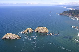
Three Arch Rocks National Wildlife Refuge is a U.S. National Wildlife Refuge off the northern Oregon Coast. It is located on the central coast of Tillamook County, in the northwestern part of Oregon. It is one of six National Wildlife Refuges within the Oregon Coast National Wildlife Refuge Complex and was the first National Wildlife Refuge west of the Mississippi River. In 1970 the Refuge was designated as wilderness. It is one of the smallest wilderness areas in the United States.
The Meredosia National Wildlife Refuge is a 5,255-acre (21.27 km2) national wildlife refuge located along the Illinois River in Cass County and Morgan County in the U.S. state of Illinois. The refuge is adjacent to Meredosia, Illinois, but is managed by the U.S. Fish and Wildlife Service from a headquarters located in Havana, Illinois.

The Middle Mississippi River National Wildlife Refuge is located on the Mississippi River downstream from St. Louis, Missouri. It is managed by the U.S. Fish and Wildlife Service as part of the Mark Twain National Wildlife Refuge Complex.
The Great River National Wildlife Refuge protects approximately 11,600 acres (47 km2) along 120 miles (190 km) of the Mississippi River, stretching north of St. Louis, Missouri. Three separate units are located in the floodplain, on both the Illinois and Missouri sides of the river.


