Crowder State Park is a public recreation area of 1,912 acres (774 ha) surrounding 18-acre (7.3 ha) Crowder Lake near Trenton in Grundy County, Missouri, USA. The state park and lake are named after Maj. General Enoch H. Crowder, who was born and raised near the park.

Ha Ha Tonka State Park is a public recreation area encompassing 3,751 acres (1,518 ha) on the Niangua arm of the Lake of the Ozarks, about five miles south of Camdenton, Missouri, in the United States. The state park's most notable feature is the ruins of Ha Ha Tonka, an early 20th-century stone mansion that was modeled after European castles of the 16th century.

Dodge No. 4 State Park is a public recreation area covering 139 acres (56 ha) on the north shore of Cass Lake in Oakland County, northern Metro Detroit, Michigan. The state park occupies a mile of shoreline on the 1,280-acre (520 ha) lake.

Thousand Hills State Park is a public recreation area covering over 3,000 acres (1,200 ha) two miles (3.2 km) west of Kirksville in Adair County, Missouri. The state park features Native American petroglyphs and 573-acre (232 ha) Forest Lake with fishing, swimming and boating.
Big Lake State Park is a public recreation area located in northwest Missouri, United States. The 407-acre (165 ha) state park was established in 1932 at the northern end of the state's largest oxbow lake, Big Lake. Park activities include boating, camping, picnicking, fishing, and swimming. Because park accommodations have been repeatedly destroyed by Missouri River floods, the park began using wheeled rental cabins that can be moved in the event of flooding in 2016.

Cuivre River State Park is a public recreation area covering more than 6,400 acres (2,600 ha) northeast of the city of Troy in the Lincoln Hills region of northeastern Missouri, United States. The state park's rugged landscapes range from native grasslands and savannas to limestone bluffs overlooking forested hills. The park offers an extensive system of hiking trails plus swimming and camping facilities and is managed by the Missouri Department of Natural Resources. It encompasses the Lincoln Hills Natural Area and two designated wild areas: Big Sugar Creek and Northwoods.

Trail of Tears State Park is a public recreation area covering 3,415 acres (1,382 ha) bordering the Mississippi River in Cape Girardeau County, Missouri. The state park stands as a memorial to those Cherokee Native Americans who died on the Cherokee Trail of Tears. The park's interpretive center features exhibits about the Trail of Tears as well as displays and specimens of local wildlife. An archaeological site in the park was added to the National Register of Historic Places in 1970.

Lake Lurleen State Park is a publicly owned recreation area located on U.S. Highway 82 approximately 9 miles (14 km) northwest of Northport in Tuscaloosa County, Alabama. The state park's 1,625 acres (658 ha) include 250-acre (100 ha) Lake Lurleen and a 23-mile (37 km) trail system. It is operated by the Alabama Department of Conservation and Natural Resources.

Grand Gulf State Park is a state-operated, privately owned and publicly accessible, geologic preserve near Thayer, Missouri, United States, encompassing a forked canyon that is the remnant of an ancient collapsed dolomite cave system. The land that is now the park was acquired by conservationist Leo Drey (1917–2015) before becoming part of the Missouri state parks system. The 322-acre (130 ha) state park has been operated by the Missouri Department of Natural Resources under a lease agreement with the L-A-D Foundation since 1984. Grand Gulf was declared a National Natural Landmark in 1971 as an excellent example of karst topography and underground stream piracy. A 60-acre (24 ha) portion of the park was designated by the state as the Grand Gulf Natural Area in 1986.

Watkins Mill is a preserved woolen mill dating to the mid-19th century, located near Lawson, Missouri, United States. The mill is protected as Watkins Woolen Mill State Historic Site, which preserve its machinery and business records in addition to the building itself. It was designated a National Historic Landmark and added to the National Register of Historic Places in 1966 in recognition for its remarkable state of preservation. The historic site is the centerpiece of Watkins Mill State Park, which is managed by the Missouri Department of Natural Resources.
Van Meter State Park is a public recreation area on the Missouri River in Saline County, Missouri. The state park consists of 1,105 acres (447 ha) of hills, ravines, fresh water marsh, fens, and bottomland and upland forests in an area known as The Pinnacles The park has several archaeological sites, a cultural center, and facilities for camping, hiking, and fishing. It is managed by the Missouri Department of Natural Resources.

Knob Noster State Park is a public recreation area covering 3,934 acres (1,592 ha) in Johnson County, Missouri, in the United States. The state park bears the name of the nearby town of Knob Noster, which itself is named for one of two small hills or "knobs" that rise up in an otherwise flat section of Missouri. Noster is a Latin adjective meaning "our"—therefore, Knob Noster translates as "our hill." A local Indian belief stated that the hills were "raised up as monuments to slain warriors." The park offers year-round camping, hiking, and fishing and is managed by the Missouri Department of Natural Resources.

Lake Wappapello State Park is a public recreation area consisting of 1,854 acres (750 ha) bordering Lake Wappapello in Wayne County, Missouri. The state park features two campgrounds, trails for hikers, bikers, backpackers, and equestrians, and swimming, fishing, and boating on the lake.

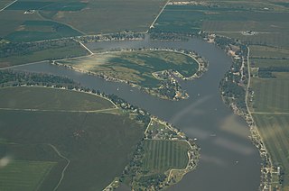
Lewis and Clark State Park is a public recreation area occupying 189 acres (76 ha) on the south shore of 365-acre (148 ha) Lewis and Clark Lake in Buchanan County, Missouri. The state park features camping, picnicking, and fishing.
Long Branch State Park is a public recreation area occupying 1,828 acres (740 ha) adjacent to the Long Branch Reservoir in Macon County, Missouri. The state park consists of three units located some two miles west of Macon, Missouri on U.S. Highway 36.

Mark Twain State Park is a public recreation area encompassing 2,788 acres (1,128 ha) on Mark Twain Lake in Monroe County, Missouri. The state park offers water recreation, hiking trails, and campgrounds. It is adjacent to the Mark Twain Birthplace State Historic Site.

Pershing State Park is a public recreation area covering more than 5,000 acres (2,000 ha) off U.S. Route 36, three miles west of Laclede in Linn County, Missouri. The state park was named in honor of General of the Armies John J. Pershing, who led the United States forces in Europe in World War I and who grew up in Laclede.

Wakonda State Park is a public recreation area covering 1,054 acres (427 ha) near La Grange in Lewis County, Missouri. The state park features water recreation on six small lakes.

Weston Bend State Park is a public recreation area on the east bank of the Missouri River in Platte County, Missouri. The state park's 1,133 acres (459 ha) include scenic river views, trails for hiking and biking, picnicking facilities, and a campground.

Madison Lake State Park is a public recreation area located four miles (6.4 km) east of London in the Darby Plains region of Madison County, Ohio, United States. The state park includes 106-acre (43 ha) Madison Lake and 76 acres (31 ha) of surrounding land.