
The Ozarks, also known as the Ozark Mountains, Ozark Highlands or Ozark Plateau, is a physiographic region in the U.S. states of Missouri, Arkansas, Oklahoma, and only ~55 square miles in the southeastern corner of Kansas. The Ozarks cover a significant portion of northern Arkansas and most of the southern half of Missouri, extending from Interstate 40 in central Arkansas to Interstate 70 in central Missouri.

The Ouachita National Forest is a vast congressionally-designated National Forest that lies in the western portion of Arkansas and portions of extreme-eastern Oklahoma, USA.

The George Washington and Jefferson National Forests is an administrative entity combining two U.S. National Forests into one of the largest areas of public land in the Eastern United States. The forests cover 1.8 million acres (2,800 sq mi) of land in the Appalachian Mountains of Virginia, West Virginia, and Kentucky. Approximately 1 million acres (1,600 sq mi) of the forest are remote and undeveloped and 139,461 acres (218 sq mi) have been designated as wilderness areas, which prohibits future development.

The Maroon Bells are two peaks in the Elk Mountains, Maroon Peak and North Maroon Peak, separated by about half a kilometer. The mountains are on the border between Pitkin County and Gunnison County, Colorado, United States, about 19 kilometres (12 mi) southwest of Aspen. Both peaks are fourteeners. Maroon Peak, at 4,317 metres (14,163 ft), is the 27th highest peak in Colorado. North Maroon Peak, at 4,273 metres (14,019 ft), is the 50th highest. The view of the Maroon Bells to the southwest from the Maroon Creek valley is very heavily photographed. The peaks are located in the Maroon Bells–Snowmass Wilderness of White River National Forest. Maroon Bells-Snowmass Wilderness was one of five areas in Colorado designated as wilderness in the original Wilderness Act of 1964. The Wilderness area surrounds the extremely popular Maroon Bells Scenic Area, which is a major access point for Wilderness travel.

The Shawnee National Forest is a United States National Forest located in the Ozark and Shawnee Hills of Southern Illinois, United States. Administered by the U.S.D.A. Forest Service, it consists of approximately 289,000 acres (1,100 km²) of federally managed lands. In descending order of land area it is located in parts of Pope, Jackson, Union, Hardin, Alexander, Saline, Gallatin, Johnson, and Massac counties. Forest headquarters are located in Harrisburg, Illinois. There are local ranger district offices in Jonesboro and Vienna. The Shawnee National Forest is also the single largest publicly owned body of land in the state of Illinois. It is considered part of Southern Illinois, and is south of the St. Louis, Missouri, and Metro East areas, in area code 618. Portions of it are in the far south area of Illinois known as Little Egypt. Cities in or near the area are Carbondale, Illinois, Marion, Illinois, and Cairo, Illinois.

Mark Twain National Forest (MTNF) is a U.S. National Forest located in the southern half of Missouri, composed of nine disconnected parcels. MTNF was established on September 11, 1939. It is named for author Mark Twain, a Missouri native. The MTNF covers 3,068,800 acres (12,419 km2) of which 1,506,100 acres (6,095 km2) is public owned, 78,000 acres (320 km2) of which are Wilderness, and National Scenic River area. MTNF spans 29 counties and represents 11% of all forested land in Missouri. MTNF's nine tracts are divided into six distinct ranger districts: Ava-Cassville-Willow Springs, Eleven Point, Houston-Rolla, Cedar Creek, Poplar Bluff, Potosi-Fredericktown, and the Salem. Its headquarters are in Rolla, Missouri.

The Gates of the Mountains Wilderness is located in the U.S. state of Montana. Created by an act of Congress in 1964, the wilderness is managed by Helena National Forest. A day use campground near the Gates of the Mountains, Meriwether Picnic site, is named in honor of Meriwether Lewis.

The Irish Wilderness is a 16,227-acre (66 km2) wilderness area in the U.S. State of Missouri. The U.S. Congress designated it a wilderness in 1984. The Irish Wilderness is located within the Eleven Point Ranger District of the Mark Twain National Forest, 10 miles (16 km) northeast of Alton, Missouri. The Irish Wilderness is one of eight wilderness areas protected and preserved in Missouri.

Hilda is an unincorporated community within the Mark Twain National Forest District in Taney County, Missouri, United States. It is located on U.S. Route 160 three miles east of the Kissee Mills recreation area on the Beaver Creek arm of Bull Shoals Lake and approximately twenty miles east of Branson.
The Piney Creek Wilderness is an 8,122-acre (33 km2) wilderness area in Missouri. The United States Congress designated it wilderness in 1980. The Piney Creek Wilderness is located within the Ava-Cassville-Willow Springs Ranger District of the Mark Twain National Forest, east of Cassville, Missouri. The area is named after Piney Creek, which runs the length of the wilderness area and eventually empties into the James River arm of Table Rock Lake. The Piney Creek Wilderness is one of eight wilderness areas of the Mark Twain National Forest that are protected and preserved in Missouri.

The United States Congress designated the Bell Mountain Wilderness in 1980. The wilderness area now has a total of 9,027 acres (36.53 km2). Bell Mountain is located within the Potosi-Fredericktown Ranger District of the Mark Twain National Forest, south of Potosi, Missouri in the United States. The wilderness lies in the Saint Francois Mountains and it was named after its highest point, Bell Mountain. The namesake Bell Mountain has the name of Henry Bell, a pioneer settler. The Bell Mountain Wilderness is one of eight wilderness areas protected and preserved in Missouri. The area is popular for hiking as there are 12 miles (19 km) of trail, including a section of the Ozark Trail.
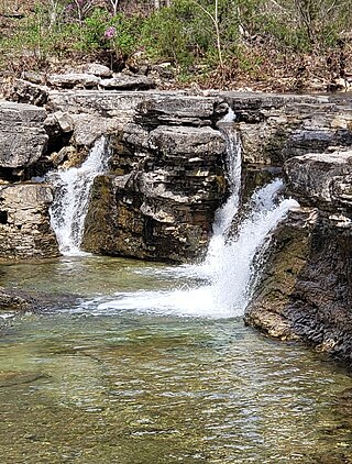
The Hercules Glades Wilderness is a 12,314-acre (50 km2) wilderness area in Taney County in the Ozarks of southwest Missouri. The United States Congress designated it a wilderness in 1976, making it the oldest wilderness area in Missouri. It is one of eight wilderness areas in the Mark Twain National Forest and is within the Ava-Cassville-Willow Springs ranger district, about 10 miles (16 km) northeast of Branson, Missouri. Hercules Glades Wilderness derives its name from the open limestone glades (balds) that dot its landscape. The high points of Coy Bald and Pilot Knob stand 600 feet above Long Creek and offer splendid views of the drainage. Near the middle of the wilderness area is the main set of waterfalls, though Long Creek has several other smaller waterfalls and cascades along its path.
The Paddy Creek Wilderness is a 7,019-acre (28.40 km2) wilderness area in the U.S. state of Missouri, United States. The United States Congress designated it wilderness in 1983. Paddy Creek Wilderness is located within the Houston-Rolla Ranger District, of the Mark Twain National Forest, 10 miles (16 km) northwest of Licking, Missouri. It was named for Big and Little Paddy Creeks that run through the area. The Paddy Creek Wilderness is one of eight wilderness areas protected and preserved in Missouri. Big Piney Trail is a 17-mile (27 km) long loop that traverses this wilderness area and is popular among avid backpackers. The 17-mile (27 km) loop trail can be hiked as a 10-mile (16 km) stretch or the 7.5-mile (12.1 km) south section. The trails are rugged and can be challenging for the inexperienced or unprepared hiker. Horseback riding is also common on the Piney Creek Trail. The Paddy Creek Recreation Area is nearby, and offers many camping amenities. There are many single sites, and a few double sites available. There is also fishing access on the Big Piney River, via a trail access from the campground.
French Mills is an unincorporated community in western Madison County, in the U.S. state of Missouri. The community is on [Little Rock Creek ], just north of that stream's confluence with the St. Francis River.
Leatherwood Creek is a stream in Iron and Madison County in the U.S. state of Missouri. It is a tributary of St. Francis River.
Marsh Creek is a stream in Madison County in the U.S. state of Missouri. It is a tributary of the St. Francis River.
Wilderness is an unincorporated community in northeast Oregon County, in the U.S. state of Missouri.

Beaver Creek is a stream in western Douglas and eastern Taney counties of Missouri. It is a tributary to the White River of northern Arkansas.
Hercules is an unincorporated community in Taney County, in the Ozarks of southern Missouri. Hercules is located on Missouri Route 125, south of Bradleyville and just northeast of the Hercules Glades Wilderness protected area. The townsite is adjacent to Brushy Creek and within the Mark Twain National Forest.
