The Ozarks, also known as the Ozark Mountains, Ozark Highlands or Ozark Plateau, is a physiographic region in the U.S. states of Missouri, Arkansas, Oklahoma and the extreme southeastern corner of Kansas. The Ozarks cover a significant portion of northern Arkansas and most of the southern half of Missouri, extending from Interstate 40 in central Arkansas to Interstate 70 in central Missouri.

The Katy Trail State Park is a state park in the U.S. state of Missouri that contains the Katy Trail, the country's longest continuous recreational rail trail. It runs 240 miles (390 km), largely along the northern bank of the Missouri River, in the right-of-way of the former Missouri–Kansas–Texas Railroad. Open year-round from sunrise to sunset, it serves hikers, joggers, and cyclists. Its hard, flat surface is of "limestone pug".

The Ozark Trail is a hiking, backpacking, and, in many places, biking and equestrian trail under construction in the Missouri Ozarks in the United States. It is intended to reach from St. Louis to Arkansas. Over 350 miles (563 km) of the trail have been completed as of 2008, and the estimated length when finished will be at least 500 miles (805 km). When joined to the Ozark Highlands Trail in Arkansas, the full hiking distance from end to end will be at least 700 miles (1,127 km), not including a large loop through the St. Francois Mountains in Missouri.

Lake of the Ozarks is a reservoir created by impounding the Osage River in the northern part of the Ozarks in central Missouri. Parts of three smaller tributaries to the Osage are included in the impoundment: the Niangua River, Grandglaize Creek, and Gravois Creek. The lake has a surface area of 54,000 acres (220 km2) and 1,150 miles (1,850 km) of shoreline. The main channel of the Osage Arm stretches 92 miles (148 km) from one end to the other. The total drainage area is over 14,000 square miles (36,000 km2). The lake's serpentine shape has earned it the nickname "the Missouri Dragon", which has, in turn, inspired the names of local institutions such as the Magic Dragon Street Meet.

Oak Mountain State Park is a public recreation area located approximately 20 miles (32 km) south of Birmingham in the northeast quadrant of the city of Pelham, Alabama, United States. It is the state's largest state park at 9,940 acres (4,020 ha) and is home to the Alabama Wildlife Center, Oak Mountain Interpretive Center, and Oak Mountain BMX Track. Park activities include hiking, running, mountain biking, swimming, camping, fishing, horseback riding, and golf. The park is managed by the Alabama Department of Conservation and Natural Resources.

Meramec State Park is a public recreation area located near Sullivan, Missouri, about 60 miles from St. Louis, along the Meramec River. The park has diverse ecosystems such as hardwood forests and glades. There are over 40 caves located throughout the park, the bedrock is dolomite. The most famous is Fisher Cave, located near the campgrounds. The park borders the Meramec Conservation Area.

Ha Ha Tonka State Park is a public recreation area encompassing over 3,700 acres (1,500 ha) on the Niangua arm of the Lake of the Ozarks, about five miles south of Camdenton, Missouri, in the United States. The state park's most notable feature is the ruins of Ha Ha Tonka, an early 20th-century stone mansion that was modeled after European castles of the 16th century.
Johnson's Shut-Ins State Park is a public recreation area covering 8,781 acres (3,554 ha) on the East Fork Black River in Reynolds County, Missouri. The state park is jointly administered with adjoining Taum Sauk Mountain State Park, and together the two parks cover more than sixteen thousand acres in the St. Francois Mountains region of the Missouri Ozarks.

Montauk State Park is a public recreation area occupying nearly 3,000 acres (1,200 ha) at the headwaters of the Current River, fifteen miles (24 km) southwest of Salem, Missouri. The state park contains a fish hatchery and is noted for its rainbow and brown trout angling. It was acquired in 1926. The park has several natural springs including Montauk Spring with a daily average flow of 53 million gallons of water.

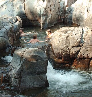
The Ozark National Scenic Riverways is a recreational unit of the National Park Service in the Ozarks of southern Missouri in the U.S.

Washington State Park is a public recreation area covering 2,147 acres (869 ha) in Washington County in the central eastern part of the state of Missouri. It is located on Highway 21 about 14 miles (23 km) northeast of Potosi or 7 miles (11 km) southwest of De Soto on the eastern edge of the Ozarks. The state park is noted for its Native American rock carvings and for its finely crafted stonework from the 1930s.

Taum Sauk Mountain State Park is a Missouri state park located in the St. Francois Mountains in the Ozarks. The park encompasses Taum Sauk Mountain, the highest point in the state. The Taum Sauk portion of the Ozark Trail connects the park with nearby Johnson's Shut-ins State Park and the Bell Mountain Wilderness Area, which together are part of a large wilderness area popular with hikers and backpackers.

Sam A. Baker State Park is a public recreation area encompassing 5,323 acres (2,154 ha) in the Saint Francois Mountains region of the Missouri Ozarks. The state park offers fishing, canoeing, swimming, camping, and trails for hiking and horseback riding. The visitor and nature center is housed in a historic building that was originally constructed as a stable in 1934.

Lake of the Ozarks State Park is a Missouri state park on the Grand Glaize Arm of the Lake of the Ozarks and is the largest state park in the state. This is also the most popular state park in Missouri, with over 2.5 million visitations in 2017.

The Felix Vallé House State Historic Site is a state-owned historic preserve comprising the Felix Vallé House and other early 19th-century buildings in Ste. Genevieve, Missouri. It is managed by the Missouri Department of Natural Resources.
Roaring River State Park is a public recreation area covering of 4,294 acres (1,738 ha) eight miles (13 km) south of Cassville in Barry County, Missouri. The state park offers trout fishing on the Roaring River, hiking on seven different trails, and the seasonally open Ozark Chinquapin Nature Center.

Devil's Den State Park is a 2,500-acre (1,000 ha) Arkansas state park in Washington County, near West Fork, Arkansas in the United States. The park was built by the Civilian Conservation Corps, beginning in 1933. Devil's Den State Park is in the Lee Creek Valley in the Boston Mountains, which are the southwestern part of The Ozarks. The park, with an 8 acres (3.2 ha) CCC-built lake, is open for year-round recreation, with trails for hiking, mountain biking and horseback riding. Devil's Den State Park also has several picnic areas, a swimming pool and cabins, with camping sites ranging from modern to primitive. Fossils of coral and crinoids can be found along the banks and within Lee Creek at Devil's Den State Park.

Echo Bluff State Park is a public recreation area comprising 476 acres (193 ha) of land in Newton Township, Shannon County, Missouri, United States. The state park occupies the site of former Camp Zoe, a summer camp for children that opened in 1929. The park was named for the massive cliff that towers over one side of Sinking Creek.
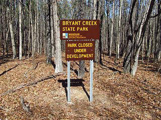
Bryant Creek State Park is one of three new Missouri state parks announced in 2016. The 2,917-acre (1,180 ha) property is located along Bryant Creek in south central Douglas County, 22 miles (35 km) southeast of Ava in the Ozarks of southern Missouri. The park is open as of September 2022. There are currently two hiking trails offering 5.1 miles of trail with plans to expand the trail system in the future.
Ozark Mountain State Park is an undeveloped public recreation area covering 1,011 acres (409 ha) in Taney County, Missouri. The state park is closed pending public input on future uses of the land. It was one of three new parks announced by Governor Jay Nixon in December 2016. It shares a border with the Ruth and Paul Henning Conservation Area and is traversed by more than two miles of Roark Creek, including a stretch of the three-mile-long East Fork Roark Creek. The site includes a one-room schoolhouse that served the former community of Garber.