
Arrow Rock is a village in Saline County, Missouri, United States, located near the Missouri River. The entire village is part of the National Historic Landmark Arrow Rock Historic District, designated by the Department of the Interior, National Park Service in 1963. It is significant in the history of Westward Expansion, the Santa Fe Trail, and 19th-century artist George Caleb Bingham. The town is well known for the Arrow Rock Lyceum Theatre, hosting over 33,000 patrons every year.

Petit Jean State Park is a 3,471-acre (1,405 ha) park in Conway County, Arkansas managed by the Arkansas Department of Parks and Tourism. It is located atop Petit Jean Mountain adjacent to the Arkansas River in the area between the Ouachita Mountains and Ozark Plateaus.

A. H. Stephens State Park is a 1,177 acres (476 ha) Georgia state park located in Crawfordville. The park is named for Alexander Hamilton Stephens, the Vice President of the Confederate States of America, and a former Georgia governor. The park contains Stephens' home, Liberty Hall, which has been fully restored to its original 1875 style. The park's museum houses one of Georgia's largest collections of Civil War artifacts. The park also offers several mill ponds for fishing and nature trails.

Meramec State Park is a public recreation area located near Sullivan, Missouri, about 60 miles from St. Louis, along the Meramec River. The park has diverse ecosystems such as hardwood forests and glades. There are over 40 caves located throughout the park, the bedrock is dolomite. The most famous is Fisher Cave, located near the campgrounds. The park borders the Meramec Conservation Area.

This is a list of properties and historic districts in Missouri on the National Register of Historic Places. There are NRHP listings in all of Missouri's 114 counties and the one independent city of St. Louis.

Washington State Park is a public recreation area covering 2,147 acres (869 ha) in Washington County in the central eastern part of the state of Missouri. It is located on Highway 21 about 14 miles (23 km) northeast of Potosi or 7 miles (11 km) southwest of DeSoto on the eastern edge of the Ozarks. The state park is noted for its Native American rock carvings and for its finely crafted stonework from the 1930s.

Sam A. Baker State Park is a public recreation area encompassing 5,323 acres (2,154 ha) in the Saint Francois Mountains region of the Missouri Ozarks. The state park offers fishing, canoeing, swimming, camping, and trails for hiking and horseback riding. The visitor and nature center is housed in a historic building that was originally constructed as a stable in 1934.
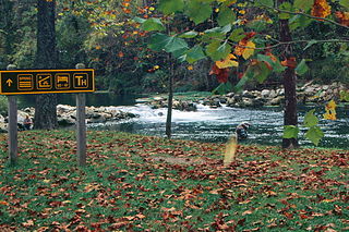
Bennett Spring State Park is a public recreation area located in Bennett Springs, Missouri, twelve miles (19 km) west of Lebanon on Highway 64 in Dallas and Laclede counties. It is centered on the spring that flows into the Niangua River and gives the park its name. The spring averages 100 million gallons of daily flow. The park offers fly fishing, camping, canoeing, hiking, and other activities.

Cuivre River State Park is a public recreation area covering more than 6,400 acres (2,600 ha) northeast of the city of Troy in the Lincoln Hills region of northeastern Missouri, United States. The state park's rugged landscapes range from native grasslands and savannas to limestone bluffs overlooking forested hills. The park offers an extensive system of hiking trails plus swimming and camping facilities and is managed by the Missouri Department of Natural Resources. It encompasses the Lincoln Hills Natural Area and two designated wild areas: Big Sugar Creek and Northwoods.

Backbone State Park is Iowa's oldest state park, dedicated in 1919. Located in the valley of the Maquoketa River, it is approximately three miles (5 km) south of Strawberry Point in Delaware County. It is named for a narrow and steep ridge of bedrock carved by a loop of the Maquoketa River originally known as the Devil's Backbone. The initial 1,200 acres (490 ha) were donated by E.M. Carr of Lamont, Iowa. Backbone Lake Dam, a relatively low dam built by the Civilian Conservation Corps (CCC) in the 1930s, created Backbone Lake. The CCC constructed a majority of trails and buildings which make up the park.

Guernsey State Park is a public recreation area surrounding the Guernsey Reservoir, an impoundment of the North Platte River, one mile northwest of the town of Guernsey in Platte County, Wyoming, USA. The state park has campgrounds, boat ramps and hiking trails as well as exceptional examples of structures created by the Civilian Conservation Corps in the 1930s. Facilities are managed for the Bureau of Reclamation by the Wyoming Division of State Parks and Historic Sites.

Arrow Rock Historic District is a National Historic Landmark District encompassing the village of Arrow Rock, Missouri and the adjacent Arrow Rock State Historic Site. The Arrow Rock area was where the historic Santa Fe Trail crossed the Missouri River, and was thus a key stopping point during the settlement of the American West. The 260-acre (1.1 km2) historic district was declared a National Historic Landmark in 1963.

The George Caleb Bingham House is a historic house, part of Arrow Rock State Historic Site in Arrow Rock, Missouri, United States. Built in 1837, it was the principal residence of portraitist and landscape painter George Caleb Bingham (1811–79) from 1837 to 1845. It was declared a National Historic Landmark in 1965.
Knob Noster State Park is a public recreation area covering 3,934 acres (1,592 ha) in Johnson County, Missouri, in the United States. The state park bears the name of the nearby town of Knob Noster, which itself is named for one of two small hills or "knobs" that rise up in an otherwise flat section of Missouri. Noster is a Latin adjective meaning "our"—therefore, Knob Noster translates as "our hill." A local Indian belief stated that the hills were "raised up as monuments to slain warriors." The park offers year-round camping, hiking, and fishing and is managed by the Missouri Department of Natural Resources.

Mark Twain State Park is a public recreation area encompassing 2,775 acres (1,123 ha) on Mark Twain Lake in Monroe County, Missouri. The state park offers water recreation, hiking trails, and campgrounds. It is adjacent to the Mark Twain Birthplace State Historic Site.
Roaring River State Park is a public recreation area covering of 4,294 acres (1,738 ha) eight miles (13 km) south of Cassville in Barry County, Missouri. The state park offers trout fishing on the Roaring River, hiking on seven different trails, and the seasonally open Ozark Chinquapin Nature Center.
Architects of the National Park Service are the architects and landscape architects who were employed by the National Park Service (NPS) starting in 1918 to design buildings, structures, roads, trails and other features in the United States National Parks. Many of their works are listed on the National Register of Historic Places, and a number have also been designated as National Historic Landmarks.

Lacey-Keosauqua State Park is located southwest of Keosauqua, Iowa, United States. The park is located along the Des Moines River in Van Buren County. First dedicated in 1921, it is the largest state park in size in Iowa. In 1990, three areas were named nationally recognized historic districts and listed on the National Register of Historic Places.

Cuba High School Annex, also known as the Crawford County Historical Society Museum, is a historic school building located at Cuba, Crawford County, Missouri. It was built in 1934 with funds provided by either the Civil Works Administration or the Works Progress Administration. It is a two-story, rectangular building built on a raised basement. It measures 60 feet by 30 feet and has a hipped roof. It is finished with random ashlar native stone laid in a “giraffe” pattern with grapevine joints.


