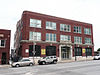
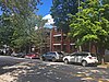
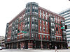
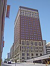
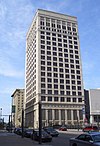
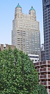
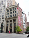
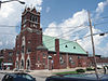
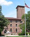
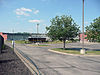
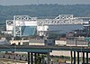
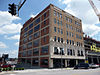
[3] Name on the Register Image Date listed [4] Location Neighborhood Description 1 Bryant Building Bryant Building April 24, 1989 (# 89000312 1102 Grand Ave. 39°06′03″N 94°34′52″W / 39.100808°N 94.581048°W / 39.100808; -94.581048 (Bryant Building ) Downtown 2 1524 Grand Avenue Building 1524 Grand Avenue Building April 15, 2004 (# 04000389 1524 Grand Boulevard 39°05′42″N 94°34′53″W / 39.094908°N 94.581342°W / 39.094908; -94.581342 (1524 Grand Avenue Building ) Crossroads 3 1901 McGee Street Automotive Service Building 1901 McGee Street Automotive Service Building January 22, 2009 (# 08001359 1901-1907 McGee St. 39°05′25″N 94°34′48″W / 39.090142°N 94.580041°W / 39.090142; -94.580041 (1901 McGee Street Automotive Service Building ) Crossroads 4 Acme Brass and Machine Works Building Acme Brass and Machine Works Building July 14, 2004 (# 04000694 609-611 E. 17th St. 39°05′35″N 94°34′34″W / 39.093095°N 94.576050°W / 39.093095; -94.576050 (Acme Brass and Machine Works Building ) Hospital Hill 5 Charles Francis Adams Jr. Building Upload image February 24, 2020 (# 100004985 1311-1315 West 13th St. 39°05′59″N 94°36′03″W / 39.0996°N 94.6008°W / 39.0996; -94.6008 (Charles Francis Adams Jr. Building ) 6 Alana Apartment Hotel Alana Apartment Hotel July 5, 2006 (# 06000543 2700-2706 Troost Ave. and 1015 E. 27th St. 39°04′39″N 94°34′16″W / 39.077562°N 94.571178°W / 39.077562; -94.571178 (Alana Apartment Hotel ) Longfellow/Dutch Hill Demolished in 2018. 7 Argyle Building Argyle Building August 17, 2005 (# 05000891 306 E. 12th St. 39°05′59″N 94°34′45″W / 39.099828°N 94.579295°W / 39.099828; -94.579295 (Argyle Building ) Downtown 8 Auto Coach Building Auto Coach Building April 18, 2007 (# 07000328 1730-34 Oak St. 39°05′32″N 94°34′45″W / 39.092154°N 94.579125°W / 39.092154; -94.579125 (Auto Coach Building ) Crossroads 9 Baker–Vawter Building Baker–Vawter Building May 5, 2000 (# 00000432 915-917 Wyandotte 39°06′11″N 94°35′07″W / 39.103087°N 94.585286°W / 39.103087; -94.585286 (Baker–Vawter Building ) Downtown 10 Blackstone Hotel Blackstone Hotel October 18, 2003 (# 03001057 817 Cherry St. 39°06′13″N 94°34′33″W / 39.103543°N 94.575910°W / 39.103543; -94.575910 (Blackstone Hotel ) Downtown 11 BMA Tower BMA Tower August 21, 2002 (# 02000886 700 West Karnes (Should be 700 West 31st Street.) 39°04′20″N 94°35′37″W / 39.072111°N 94.593619°W / 39.072111; -94.593619 (BMA Tower ) West Side 12 Boley Building Boley Building March 9, 1971 (# 71000467 1130 Walnut St. 39°06′00″N 94°34′56″W / 39.1°N 94.582222°W / 39.1; -94.582222 (Boley Building ) Downtown 13 Bonfils Building Bonfils Building March 22, 1984 (# 84002568 1200 Grand Ave. 39°05′59″N 94°34′52″W / 39.099708°N 94.581144°W / 39.099708; -94.581144 (Bonfils Building ) Downtown 14 Buick Automobile Company Building Buick Automobile Company Building May 5, 2004 (# 04000386 216 Admiral Boulevard 39°06′20″N 94°34′48″W / 39.105514°N 94.579900°W / 39.105514; -94.579900 (Buick Automobile Company Building ) Downtown 15 Bunker Building Bunker Building September 5, 1975 (# 75001067 820 Baltimore Ave. 39°06′14″N 94°35′04″W / 39.103829°N 94.584519°W / 39.103829; -94.584519 (Bunker Building ) Downtown 16 Chambers Building Chambers Building December 28, 2001 (# 01001379 25 E. 12th St. 39°05′59″N 94°34′57″W / 39.099771°N 94.582366°W / 39.099771; -94.582366 (Chambers Building ) Downtown 17 Cherry Street Colonnades Historic District Cherry Street Colonnades Historic District September 22, 2005 (# 05001050 2523, 2527, 2531, 2535, 2539, 2543, 2547, 2542, and 2544 Cherry St. 39°04′48″N 94°34′38″W / 39.080129°N 94.577177°W / 39.080129; -94.577177 (Cherry Street Colonnades Historic District ) Longfellow/Dutch Hill 18 Christian Church Hospital Christian Church Hospital October 21, 2004 (# 04001161 2697 West Paseo Boulevard (NRHP application incorrectly gives 2524 W. Paseo Boulevard.) 39°04′42″N 94°33′59″W / 39.078455°N 94.566320°W / 39.078455; -94.566320 (Christian Church Hospital ) Beacon Hill-McFeders 19 City Bank Building City Bank Building February 17, 1983 (# 83000996 1801 Grand Ave. 39°05′30″N 94°34′51″W / 39.091667°N 94.580833°W / 39.091667; -94.580833 (City Bank Building ) Crossroads 20 Coates House Hotel Coates House Hotel February 23, 1972 (# 72000715 1005 Broadway 39°06′08″N 94°35′17″W / 39.102222°N 94.588056°W / 39.102222; -94.588056 (Coates House Hotel ) Downtown 21 Coca-Cola Building Coca-Cola Building August 18, 1988 (# 88001300 2101-2111 Grand Ave. 39°05′15″N 94°34′53″W / 39.0874°N 94.5813°W / 39.0874; -94.5813 (Coca-Cola Building ) Crown Center Also known as the Western Auto Building 22 Columbia Building Columbia Building May 5, 2000 (# 00000433 2006-2012 Wyandotte St. 39°05′20″N 94°35′11″W / 39.0889°N 94.5863°W / 39.0889; -94.5863 (Columbia Building ) Crossroads 23 Commerce Tower Commerce Tower April 11, 2014 (# 14000141 911 Main St. 39°06′12″N 94°34′58″W / 39.1033°N 94.5829°W / 39.1033; -94.5829 (Commerce Tower ) Downtown 24 Commerce Trust Company Historic District Commerce Trust Company Historic District November 9, 2015 (# 15000772 Bounded by E. 9th, Walnut, E. 10th & Main Sts. 39°06′10″N 94°34′57″W / 39.1028°N 94.5826°W / 39.1028; -94.5826 (Commerce Trust Company Historic District ) Downtown 25 Continental Hotel Continental Hotel August 8, 1983 (# 83000997 106 W. 11th St. 39°06′04″N 94°35′04″W / 39.1010°N 94.5844°W / 39.1010; -94.5844 (Continental Hotel ) Downtown Also known as Mark Twain Tower 26 Thos. Corrigan Building Thos. Corrigan Building September 16, 1982 (# 82003143 1828 Walnut St. 39°05′26″N 94°34′58″W / 39.0906°N 94.5828°W / 39.0906; -94.5828 (Thos. Corrigan Building ) Crossroads 27 The Crane Company Building The Crane Company Building May 18, 2018 (# 100002424 1105-1107 Hickory St. 39°06′05″N 94°36′05″W / 39.1014°N 94.6014°W / 39.1014; -94.6014 (The Crane Company Building ) West Bottoms 28 Creamery Package Manufacturing Company Building Creamery Package Manufacturing Company Building November 7, 2016 (# 16000764 1408-1410 W. 12th St. 39°06′03″N 94°36′06″W / 39.1009°N 94.6018°W / 39.1009; -94.6018 (Creamery Package Manufacturing Company Building ) West Bottoms 29 Crossroads Historic Freight District Upload image December 22, 2000 (# 00001565 Roughly bounded by Southwest Boulevard, W. 20th St., Baltimore Ave., W. 22nd St., and Broadway 39°05′18″N 94°35′13″W / 39.0882°N 94.5869°W / 39.0882; -94.5869 (Crossroads Historic Freight District ) Crossroads 30 Crown Center Historic District Upload image November 14, 2019 (# 100004601 Bounded by Main St., Pershing Rd., 27th St., McGee St., Trfy, Grand Blvd. 39°05′21″N 94°34′57″W / 39.0891°N 94.5826°W / 39.0891; -94.5826 (Crown Center Historic District ) 31 Louis Curtiss Studio Building Louis Curtiss Studio Building June 19, 1972 (# 72000716 1116-1120 McGee St. 39°06′01″N 94°34′48″W / 39.1003°N 94.5799°W / 39.1003; -94.5799 (Louis Curtiss Studio Building ) Downtown 32 Dierks Building Dierks Building January 29, 2009 (# 08001387 1000-1006 Grand Boulevard 39°06′08″N 94°34′51″W / 39.1023°N 94.5808°W / 39.1023; -94.5808 (Dierks Building ) Downtown 33 District I Upload image August 8, 1983 (# 83001000 Roughly bounded by Baltimore Ave. and W. 12th, W. 13th, and Wyandotte Sts. 39°05′59″N 94°35′04″W / 39.0997°N 94.5844°W / 39.0997; -94.5844 (District I ) Downtown 34 East Ninth Street-Grand Boulevard Historic District Upload image October 9, 2020 (# 100005660 Roughly bounded by Main, McGee, East 8th and East 10th Sts. 39°06′13″N 94°34′53″W / 39.1035°N 94.5815°W / 39.1035; -94.5815 (East Ninth Street-Grand Boulevard Historic District ) 35 Exchange Building Upload image June 13, 2003 (# 03000524 1201-1207 Grand Boulevard 39°06′06″N 94°34′49″W / 39.1017°N 94.5803°W / 39.1017; -94.5803 (Exchange Building ) Downtown Demolished. 36 Executive Plaza Office Building Executive Plaza Office Building March 13, 2017 (# 100000750 720 Main St. 39°06′17″N 94°35′00″W / 39.1047°N 94.5832°W / 39.1047; -94.5832 (Executive Plaza Office Building ) Downtown 37 The Fairfax Building The Fairfax Building July 22, 2015 (# 15000471 101 W. 11th St. 39°06′03″N 94°35′04″W / 39.1009°N 94.5845°W / 39.1009; -94.5845 (The Fairfax Building ) Downtown 38 Faultless Starch Company Building Faultless Starch Company Building May 9, 2002 (# 02000470 1025 W. 8th St. 39°06′19″N 94°35′45″W / 39.1054°N 94.5958°W / 39.1054; -94.5958 (Faultless Starch Company Building ) West Bottoms 39 Federal Office Building Federal Office Building August 2, 2021 (# 100006773 601 East 12th St. 39°05′56″N 94°34′34″W / 39.0988°N 94.5761°W / 39.0988; -94.5761 (Federal Office Building ) AKA the Richard Bolling Federal Building 40 Federal Reserve Bank of Kansas City Federal Reserve Bank of Kansas City April 10, 2007 (# 07000327 925 Grand Boulevard 39°06′14″N 94°34′49″W / 39.1039°N 94.5802°W / 39.1039; -94.5802 (Federal Reserve Bank of Kansas City ) Downtown 41 The Fidelity National Bank and Trust Company Building The Fidelity National Bank and Trust Company Building August 14, 1997 (# 97000908 911 Walnut St. 39°06′11″N 94°34′54″W / 39.1031°N 94.5816°W / 39.1031; -94.5816 (The Fidelity National Bank and Trust Company Building ) Downtown 42 Fire Department Headquarters; Fire station No. 2 Fire Department Headquarters; Fire station No. 2 September 2, 1982 (# 82003144 1020 Central Ave. 39°06′05″N 94°35′14″W / 39.1015°N 94.5871°W / 39.1015; -94.5871 (Fire Department Headquarters; Fire station No. 2 ) Downtown 43 Firestone Building Firestone Building January 3, 1986 (# 86000004 2001 Grand Ave. 39°05′20″N 94°34′51″W / 39.088889°N 94.580833°W / 39.088889; -94.580833 (Firestone Building ) Crown Center 44 Gate City National Bank Gate City National Bank September 2, 1982 (# 82003145 1111 Grand Ave. 39°06′02″N 94°34′50″W / 39.100616°N 94.580689°W / 39.100616; -94.580689 (Gate City National Bank ) Downtown 45 Globe Storage and Transfer Company Building Globe Storage and Transfer Company Building April 18, 2007 (# 07000326 1712 Main St. 39°05′35″N 94°35′01″W / 39.092919°N 94.583659°W / 39.092919; -94.583659 (Globe Storage and Transfer Company Building ) Crossroads 46 Gloyd Building Upload image July 25, 1985 (# 85001610 921 Walnut St. 39°06′10″N 94°34′53″W / 39.102778°N 94.581389°W / 39.102778; -94.581389 (Gloyd Building ) Downtown Demolished in 2001. 47 Grand Avenue Garage Grand Avenue Garage February 3, 2015 (# 14001238 718 Grand Ave. 39°06′18″N 94°34′52″W / 39.104862°N 94.580976°W / 39.104862; -94.580976 (Grand Avenue Garage ) Downtown Demolished 48 Grand Avenue Temple and Grand Avenue Temple Building Grand Avenue Temple and Grand Avenue Temple Building May 8, 1985 (# 85001006 205 E. 9th St. and 903 Grand Ave. 39°06′12″N 94°34′50″W / 39.103333°N 94.580556°W / 39.103333; -94.580556 (Grand Avenue Temple and Grand Avenue Temple Building ) Downtown 49 Graphic Arts Building Graphic Arts Building August 4, 2005 (# 05000810 934 Wyandotte St. 39°06′09″N 94°35′08″W / 39.102424°N 94.585674°W / 39.102424; -94.585674 (Graphic Arts Building ) Downtown 50 Greenlease Cadillac Building Greenlease Cadillac Building June 13, 2003 (# 03000523 2900 Gillham Rd. 39°04′25″N 94°34′44″W / 39.073744°N 94.579018°W / 39.073744; -94.579018 (Greenlease Cadillac Building ) Union Hill 51 Guadalupe Center Guadalupe Center September 2, 2003 (# 03000866 1015 Avenida de Cesar Chavez 39°05′09″N 94°35′49″W / 39.085783°N 94.596945°W / 39.085783; -94.596945 (Guadalupe Center ) West Side 52 Gumbel Building Gumbel Building January 22, 1979 (# 79001367 801 Walnut St. 39°06′15″N 94°34′54″W / 39.104302°N 94.581592°W / 39.104302; -94.581592 (Gumbel Building ) Downtown 53 Helping Hand Institute Building Helping Hand Institute Building May 5, 2000 (# 00000434 523 Grand Boulevard 39°06′29″N 94°34′48″W / 39.108062°N 94.580069°W / 39.108062; -94.580069 (Helping Hand Institute Building ) River Market 54 Hesse Carriage Company Building Hesse Carriage Company Building March 21, 2007 (# 07000169 1700 Oak St. 39°05′35″N 94°34′45″W / 39.093152°N 94.579116°W / 39.093152; -94.579116 (Hesse Carriage Company Building ) Crossroads 55 Holy Rosary Historic District Holy Rosary Historic District February 7, 2007 (# 07000007 Roughly bounded by 5th and Campbell, 5th and Harrison, and 9th and E. Missouri Ave. (More precisely, 5th to Missouri, and Campbell to Harrison.) 39°06′34″N 94°34′21″W / 39.1094°N 94.572481°W / 39.1094; -94.572481 (Holy Rosary Historic District ) Columbus Park 56 Hoover Brothers Building Upload image November 14, 2019 (# 100004600 922 Oak St. 39°06′09″N 94°34′42″W / 39.1025°N 94.5784°W / 39.1025; -94.5784 (Hoover Brothers Building ) 57 Hotel Phillips Hotel Phillips June 4, 1979 (# 79001369 106 W. 12th St. 39°06′00″N 94°35′05″W / 39.100030°N 94.584605°W / 39.100030; -94.584605 (Hotel Phillips ) Downtown 58 Frank M. Howe Residence Frank M. Howe Residence April 18, 1985 (# 85000854 1707 Jefferson St. 39°05′33″N 94°35′31″W / 39.092390°N 94.592020°W / 39.092390; -94.592020 (Frank M. Howe Residence ) West Side 59 Imperial Brewing Company Brewery Imperial Brewing Company Brewery February 11, 2011 (# 11000011 2825 Southwest Boulevard 39°04′37″N 94°36′11″W / 39.076810°N 94.603073°W / 39.076810; -94.603073 (Imperial Brewing Company Brewery ) West Side 60 Insurance Building-Consumers Cooperative Association Building Insurance Building-Consumers Cooperative Association Building November 25, 2005 (# 05001327 318-320 E. 10th St. 39°06′09″N 94°34′45″W / 39.102392°N 94.579256°W / 39.102392; -94.579256 (Insurance Building-Consumers Cooperative Association Building ) Downtown 61 Inter-State Building Inter-State Building June 12, 2008 (# 08000534 417 E. 13th St./1300 Locust St. 39°05′54″N 94°34′40″W / 39.098273°N 94.577794°W / 39.098273; -94.577794 (Inter-State Building ) Downtown 62 Interstate Securities Building Interstate Securities Building October 23, 2017 (# 100001759 215 E. 18th St. 39°05′30″N 94°34′50″W / 39.091681°N 94.580455°W / 39.091681; -94.580455 (Interstate Securities Building ) 63 Jenkins Music Company Building Jenkins Music Company Building March 2, 1979 (# 79001370 1217-1223 Walnut St. 39°05′57″N 94°34′55″W / 39.099148°N 94.581968°W / 39.099148; -94.581968 (Jenkins Music Company Building ) Downtown 64 Jensen-Salsbery Laboratories Jensen-Salsbery Laboratories July 16, 1985 (# 85001574 520 W. Pennway St. 39°05′16″N 94°35′27″W / 39.087778°N 94.590833°W / 39.087778; -94.590833 (Jensen-Salsbery Laboratories ) West Side 65 Kansas City Club Building Kansas City Club Building November 19, 2002 (# 02001401 1228 Baltimore Ave. 39°05′56″N 94°35′05″W / 39.098781°N 94.584734°W / 39.098781; -94.584734 (Kansas City Club Building ) Downtown 66 Kansas City Cold Storage Company Building Kansas City Cold Storage Company Building June 1, 2005 (# 05000510 500 E. 3rd St. 39°06′40″N 94°34′43″W / 39.111183°N 94.578607°W / 39.111183; -94.578607 (Kansas City Cold Storage Company Building ) River Market 67 Kansas City Live Stock Exchange Kansas City Live Stock Exchange April 5, 1984 (# 84002571 1600 Genessee St. 39°05′40″N 94°36′19″W / 39.094444°N 94.605278°W / 39.094444; -94.605278 (Kansas City Live Stock Exchange ) West Side 68 Kansas City Parks and Boulevards Historic District Upload image August 9, 2016 (# 14000931 Roughly bounded by Missouri R. , Hardesty Ave., Armour Blvd. & State Line. 39°04′57″N 94°33′18″W / 39.082598°N 94.555041°W / 39.082598; -94.555041 (Kansas City Parks and Boulevards Historic District ) 69 Kansas City Police Station Number 4 Kansas City Police Station Number 4 October 26, 2005 (# 05001184 103 W. 19th St. 39°05′27″N 94°35′07″W / 39.090781°N 94.585284°W / 39.090781; -94.585284 (Kansas City Police Station Number 4 ) Crossroads 70 Kansas City Power and Light Company Building Kansas City Power and Light Company Building January 9, 2002 (# 88001852 1330 Baltimore Ave. 39°05′51″N 94°35′05″W / 39.097554°N 94.584720°W / 39.097554; -94.584720 (Kansas City Power and Light Company Building ) Downtown 71 Kansas City Power and Light Company Substation "A" Kansas City Power and Light Company Substation "A" January 29, 2018 (# 100002032 2645 Madison Ave. 39°04′43″N 94°35′43″W / 39.078723°N 94.595310°W / 39.078723; -94.595310 (Kansas City Power and Light Company Substation "A" ) 72 Kansas City Public Library Kansas City Public Library May 23, 1977 (# 77000807 500 E. 9th St. 39°06′13″N 94°34′37″W / 39.103489°N 94.577015°W / 39.103489; -94.577015 (Kansas City Public Library ) Downtown 73 Kansas City Public Library and Board of Education Building Kansas City Public Library and Board of Education Building October 24, 2017 (# 100001350 1211 McGee St. 39°05′58″N 94°34′47″W / 39.099362°N 94.579761°W / 39.099362; -94.579761 (Kansas City Public Library and Board of Education Building ) Demolished in 2020. [5] 74 Kansas City Southern Railway Building Kansas City Southern Railway Building May 6, 2004 (# 04000392 114 W. 11th St. 39°06′04″N 94°35′07″W / 39.101076°N 94.585187°W / 39.101076; -94.585187 (Kansas City Southern Railway Building ) Downtown 75 Kansas City Star Building Kansas City Star Building June 24, 2019 (# 100004102 1729 Grand Blvd. 39°05′34″N 94°34′53″W / 39.0927°N 94.5813°W / 39.0927; -94.5813 (Kansas City Star Building ) 76 Kansas City Terminal Railway Company Roundhouse Historic District Kansas City Terminal Railway Company Roundhouse Historic District January 26, 2001 (# 00001682 Junction of 27th St. and Southwest Boulevard 39°04′46″N 94°36′04″W / 39.079402°N 94.600990°W / 39.079402; -94.600990 (Kansas City Terminal Railway Company Roundhouse Historic District ) West Side 77 Kansas City Title and Trust Building Kansas City Title and Trust Building June 25, 2005 (# 05000624 927 Walnut St. 39°06′09″N 94°34′54″W / 39.102424°N 94.581786°W / 39.102424; -94.581786 (Kansas City Title and Trust Building ) Downtown 78 Kansas City Water Department Building Kansas City Water Department Building April 7, 1994 (# 94000290 201 Main St. 39°06′38″N 94°35′00″W / 39.110678°N 94.583456°W / 39.110678; -94.583456 (Kansas City Water Department Building ) River Market 79 Kansas City, Missouri Western Union Telegraph Building Kansas City, Missouri Western Union Telegraph Building February 12, 2003 (# 03000010 100-114 E. 7th St. 39°06′20″N 94°34′53″W / 39.105641°N 94.581391°W / 39.105641; -94.581391 (Kansas City, Missouri Western Union Telegraph Building ) Downtown 80 Kelley-Reppert Motor Company Building Kelley-Reppert Motor Company Building November 12, 2004 (# 04001223 422 Admiral Boulevard 39°06′20″N 94°34′40″W / 39.105521°N 94.577676°W / 39.105521; -94.577676 (Kelley-Reppert Motor Company Building ) Downtown 81 Kellogg-Mackay Company Buildings Upload image June 27, 2022 (# 100007816 2020-2030 Walnut St. 39°05′17″N 94°34′58″W / 39.0881°N 94.5827°W / 39.0881; -94.5827 (Kellogg-Mackay Company Buildings ) 82 Kemper Arena Kemper Arena September 9, 2016 (# 14000160 1800 Genessee Street 39°05′31″N 94°36′21″W / 39.09194°N 94.60583°W / 39.09194; -94.60583 (Kemper Arena ) Downtown Revolutionary 1974 Helmut Jahn design has hosted political conventions as well as NBA and NHL games 83 Kirkwood Building Kirkwood Building July 25, 2001 (# 01000767 1737-41 McGee St. 39°05′30″N 94°34′43″W / 39.091758°N 94.578730°W / 39.091758; -94.578730 (Kirkwood Building ) Crossroads 84 Land Bank Building Land Bank Building January 18, 1985 (# 85000101 15 W. 10th St. 39°06′08″N 94°35′01″W / 39.102093°N 94.583686°W / 39.102093; -94.583686 (Land Bank Building ) Downtown 85 Liberty Memorial Liberty Memorial October 6, 2000 (# 00001148 100 W. 26th St. 39°04′52″N 94°35′09″W / 39.081054°N 94.585957°W / 39.081054; -94.585957 (Liberty Memorial ) Crown Center 86 Liquid Carbonic Company Building Liquid Carbonic Company Building April 29, 1994 (# 94000365 2000 Baltimore St. 39°05′20″N 94°35′06″W / 39.088910°N 94.585057°W / 39.088910; -94.585057 (Liquid Carbonic Company Building ) Crossroads 87 Loew's Midland Theater–Midland Building Loew's Midland Theater–Midland Building September 28, 1977 (# 77000808 1232-1234 Main St. and 1221-1233 Baltimore Ave. 39°05′56″N 94°35′01″W / 39.098829°N 94.583483°W / 39.098829; -94.583483 (Loew's Midland Theater–Midland Building ) Downtown 88 R.A. Long Building R.A. Long Building January 8, 2003 (# 02001683 928 Grand Boulevard 39°06′09″N 94°34′52″W / 39.102372°N 94.581088°W / 39.102372; -94.581088 (R.A. Long Building ) Downtown 89 Lowe and Campbell Sporting Goods Building Lowe and Campbell Sporting Goods Building January 12, 2012 (# 11001018 1509-13 Baltimore Ave. 39°05′44″N 94°35′04″W / 39.095578°N 94.584525°W / 39.095578; -94.584525 (Lowe and Campbell Sporting Goods Building ) Crossroads 90 Mainstreet Theatre Mainstreet Theatre February 15, 2007 (# 07000043 1400 Main St. 39°05′49″N 94°35′01″W / 39.097016°N 94.583619°W / 39.097016; -94.583619 (Mainstreet Theatre ) Downtown 91 Marks and Garvey Historic District Marks and Garvey Historic District June 26, 2006 (# 06000542 2429, 2433, and 2437 Tracy Ave. 39°04′57″N 94°34′04″W / 39.082374°N 94.567853°W / 39.082374; -94.567853 (Marks and Garvey Historic District ) Beacon Hill-McFeders 92 Albert Marty Building Albert Marty Building February 5, 2013 (# 12001257 1412-1418 W. 12th St. 39°06′03″N 94°36′08″W / 39.100890°N 94.602232°W / 39.100890; -94.602232 (Albert Marty Building ) West Bottoms 93 Mason Building Upload image September 13, 2021 (# 100006891 1110 Grand Blvd. 39°06′02″N 94°34′52″W / 39.1006°N 94.5810°W / 39.1006; -94.5810 (Mason Building ) 94 McGee Street Automotive Historic District Upload image May 20, 2018 (# 100002427 Bounded by E 17th, & E 20th Sts., McGee St. at the 1700 & 1900 blocks, Alleys between McGee and Grand at 1800 blk. & McGee & Oak Sts. 39°05′30″N 94°34′51″W / 39.0917°N 94.5807°W / 39.0917; -94.5807 (McGee Street Automotive Historic District ) 95 Mercantile Bank & Trust Building Mercantile Bank & Trust Building December 31, 2009 (# 09000830 1101 Walnut St. 39°06′03″N 94°34′55″W / 39.100939°N 94.581836°W / 39.100939; -94.581836 (Mercantile Bank & Trust Building ) Downtown 96 Midwest Hotel Midwest Hotel May 6, 2004 (# 04000394 1925 Main St. 39°05′22″N 94°35′01″W / 39.0895°N 94.5835°W / 39.0895; -94.5835 (Midwest Hotel ) Crossroads 97 Moline Plow Company Building Moline Plow Company Building June 17, 2019 (# 100004065 1015 Mulberry St. 39°06′06″N 94°35′59″W / 39.1018°N 94.5998°W / 39.1018; -94.5998 (Moline Plow Company Building ) West Bottoms 98 Monroe Hotel Monroe Hotel May 6, 2004 (# 04000395 1904-06 Main St. 39°05′24″N 94°35′02″W / 39.0900°N 94.5839°W / 39.0900; -94.5839 (Monroe Hotel ) Crossroads 99 Montgomery Ward and Company General Merchandise Warehouse Montgomery Ward and Company General Merchandise Warehouse July 8, 2010 (# 10000461 819 E. 19th St. 39°05′24″N 94°34′24″W / 39.089941°N 94.573397°W / 39.089941; -94.573397 (Montgomery Ward and Company General Merchandise Warehouse ) Hospital Hill 100 C.A. Murdock Manufacturing Company Building C.A. Murdock Manufacturing Company Building May 10, 2016 (# 16000234 1225-1227 Union Avenue 39°06′09″N 94°35′57″W / 39.102455°N 94.599230°W / 39.102455; -94.599230 (C.A. Murdock Manufacturing Company Building ) 101 National Bank of Commerce Building National Bank of Commerce Building May 5, 1999 (# 99000530 922-924 Walnut St. 39°06′09″N 94°34′55″W / 39.102571°N 94.582041°W / 39.102571; -94.582041 (National Bank of Commerce Building ) Downtown 102 National Garage Upload image May 5, 2000 (# 00000436 1100-1110 McGee St. 39°06′12″N 94°34′47″W / 39.103333°N 94.579722°W / 39.103333; -94.579722 (National Garage ) Downtown Demolished in 2004. 103 New York Life Building New York Life Building July 8, 1970 (# 70000336 20 W. 9th St. 39°06′13″N 94°35′03″W / 39.103708°N 94.584072°W / 39.103708; -94.584072 (New York Life Building ) Downtown 104 Old New England Building Old New England Building October 25, 1973 (# 73001040 112 W. 9th St. 39°06′14″N 94°35′07″W / 39.103797°N 94.585206°W / 39.103797; -94.585206 (Old New England Building ) Downtown 105 Old Town Historic District Old Town Historic District June 7, 1978 (# 78001656 Roughly bounded by Independence Ave., 2nd, Delaware and Walnut Sts.; also 119, 207, and 213 Walnut St.; also 136 Main St.; also 140 Walnut St.; also roughly bounded by E. 2nd, Locust, and Walnut Sts., and E. Missouri Ave. 39°06′32″N 94°34′59″W / 39.108889°N 94.583056°W / 39.108889; -94.583056 (Old Town Historic District ) River Market Second through fifth sets of boundaries represent boundary increases of July 1, 2005 , October 5, 2005 , February 14, 2006 , and January 17, 2012 106 Palace Clothing Company Building Palace Clothing Company Building January 18, 1985 (# 85000102 1126-1128 Grand Ave. 39°06′00″N 94°34′52″W / 39.100050°N 94.581224°W / 39.100050; -94.581224 (Palace Clothing Company Building ) Downtown 107 George B. Peck Dry Goods Company Building George B. Peck Dry Goods Company Building April 30, 1980 (# 80002368 1044 Main St. 39°06′04″N 94°35′01″W / 39.101111°N 94.583611°W / 39.101111; -94.583611 (George B. Peck Dry Goods Company Building ) Downtown 108 Thomas J. Pendergast Headquarters Thomas J. Pendergast Headquarters October 25, 2011 (# 11000764 1908 Main St. 39°05′24″N 94°35′02″W / 39.089922°N 94.583891°W / 39.089922; -94.583891 (Thomas J. Pendergast Headquarters ) Crossroads 109 Pennbroke Apartments Pennbroke Apartments April 15, 2009 (# 09000206 604 W. 10th St. 39°06′09″N 94°35′29″W / 39.102630°N 94.591416°W / 39.102630; -94.591416 (Pennbroke Apartments ) Quality Hill 110 Joseph Grear Peppard House Joseph Grear Peppard House March 26, 1985 (# 85000649 1704 Jefferson St. 39°05′34″N 94°35′33″W / 39.092778°N 94.5925°W / 39.092778; -94.5925 (Joseph Grear Peppard House ) West Side 111 Perfection Stove Company Building Perfection Stove Company Building July 14, 2014 (# 14000376 1200 Union Ave. 39°06′09″N 94°35′54″W / 39.102544°N 94.598438°W / 39.102544; -94.598438 (Perfection Stove Company Building ) West Bottoms 112 Nelle E. Peters Troost Avenue Historic District Nelle E. Peters Troost Avenue Historic District July 23, 2009 (# 09000552 2719-37 and 2730 Troost Ave. 39°04′36″N 94°34′15″W / 39.076805°N 94.570745°W / 39.076805; -94.570745 (Nelle E. Peters Troost Avenue Historic District ) Beacon Hill-McFeders 113 Pickwick Hotel, Office Building, Parking Garage and Bus Terminal Pickwick Hotel, Office Building, Parking Garage and Bus Terminal March 29, 2005 (# 05000220 901-937 McGee St., 301-311 E. 9th St., 300-310 E. Tenth St., and 906-912 Oak St. 39°06′10″N 94°34′46″W / 39.102827°N 94.579311°W / 39.102827; -94.579311 (Pickwick Hotel, Office Building, Parking Garage and Bus Terminal ) Downtown 114 President Hotel President Hotel August 8, 1983 (# 83001016 1327-1335 Baltimore Ave. 39°05′52″N 94°35′03″W / 39.097778°N 94.584167°W / 39.097778; -94.584167 (President Hotel ) Downtown 115 Professional Building Professional Building July 17, 1979 (# 79001373 1101-1107 Grand Ave. 39°06′03″N 94°34′49″W / 39.100833°N 94.580278°W / 39.100833; -94.580278 (Professional Building ) Downtown 116 Quality Hill Quality Hill July 7, 1978 (# 78001657 Roughly bounded by Broadway, 10th, 14th, and Jefferson Sts. 39°06′00″N 94°35′26″W / 39.1°N 94.590556°W / 39.1; -94.590556 (Quality Hill ) Quality Hill 117 Quality Hill Center Historic District Upload image April 3, 2017 (# 100000824 817, 905, 929 Jefferson St. & 910 Pennsylvania Ave. 39°06′12″N 94°35′30″W / 39.103357°N 94.591762°W / 39.103357; -94.591762 (Quality Hill Center Historic District ) Quality Hill 118 Richards and Conover Hardware Company Building Richards and Conover Hardware Company Building January 21, 1999 (# 98001636 200 W. 5th St. 39°06′28″N 94°35′08″W / 39.107877°N 94.585585°W / 39.107877; -94.585585 (Richards and Conover Hardware Company Building ) River Market 119 Ridenour–Baker Grocery Company Building Ridenour–Baker Grocery Company Building April 21, 2014 (# 14000161 933 Mulberry St. 39°06′11″N 94°35′58″W / 39.103157°N 94.599432°W / 39.103157; -94.599432 (Ridenour–Baker Grocery Company Building ) West Bottoms Demolition started March 2024. 120 Rieger Hotel Rieger Hotel May 6, 2004 (# 04000396 1922 Main St. 39°05′22″N 94°35′02″W / 39.089456°N 94.583909°W / 39.089456; -94.583909 (Rieger Hotel ) Crossroads 121 Sacred Heart Church, School and Rectory Sacred Heart Church, School and Rectory November 14, 1978 (# 78001659 2540-2544 Madison Ave. and 910 W. 26th St. 39°04′50″N 94°35′44″W / 39.080556°N 94.595556°W / 39.080556; -94.595556 (Sacred Heart Church, School and Rectory ) West Side 122 Safeway Stores and Office and Warehouse Building Safeway Stores and Office and Warehouse Building May 5, 2000 (# 00000435 2029-2043 Wyandotte St. 39°05′17″N 94°35′10″W / 39.087924°N 94.586005°W / 39.087924; -94.586005 (Safeway Stores and Office and Warehouse Building ) Crossroads 123 St. Mary's Episcopal Church St. Mary's Episcopal Church November 7, 1978 (# 78001663 1307 Holmes St. 39°05′53″N 94°34′28″W / 39.098056°N 94.574444°W / 39.098056; -94.574444 (St. Mary's Episcopal Church ) Downtown 124 Savoy Hotel and Grill Savoy Hotel and Grill December 30, 1974 (# 74001073 219 W. 9th St. and 9th and Central Sts. 39°06′13″N 94°35′12″W / 39.103611°N 94.586667°W / 39.103611; -94.586667 (Savoy Hotel and Grill ) Downtown 125 Scarritt Building and Arcade Scarritt Building and Arcade March 9, 1971 (# 71000468 Corner of 9th and Grand Sts. and 819 Walnut St. 39°06′13″N 94°34′52″W / 39.1036°N 94.5811°W / 39.1036; -94.5811 (Scarritt Building and Arcade ) Downtown 126 Sewall Paint and Glass Company Building Sewall Paint and Glass Company Building May 9, 2002 (# 02000469 1009-1013 W. 8th St. 39°06′20″N 94°35′43″W / 39.1056°N 94.5953°W / 39.1056; -94.5953 (Sewall Paint and Glass Company Building ) West Bottoms 127 Smith and Sons Manufacturing Company Building Upload image December 18, 2007 (# 07001290 1400-26 Guinotte Ave. 39°06′56″N 94°33′58″W / 39.1156°N 94.5661°W / 39.1156; -94.5661 (Smith and Sons Manufacturing Company Building ) Columbus Park Demolished about 2010. 128 Southwestern Bell Administration Building Upload image October 19, 2020 (# 100005679 500 East 8th St. 39°06′15″N 94°34′36″W / 39.1043°N 94.5766°W / 39.1043; -94.5766 (Southwestern Bell Administration Building ) 129 E. R. Squibb and Sons Building E. R. Squibb and Sons Building December 7, 2010 (# 10000985 2500 W. Pennyway St. 39°04′55″N 94°35′32″W / 39.0819°N 94.5922°W / 39.0819; -94.5922 (E. R. Squibb and Sons Building ) West Side 130 Standard Theatre Standard Theatre June 5, 1974 (# 74001074 300 W. 12th St. 39°06′01″N 94°35′14″W / 39.1002°N 94.5872°W / 39.1002; -94.5872 (Standard Theatre ) Downtown 131 R.O. Stenzel & Company, Warehouse R.O. Stenzel & Company, Warehouse July 18, 2007 (# 07000702 1811 Walnut 39°05′29″N 94°34′56″W / 39.0913°N 94.5823°W / 39.0913; -94.5823 (R.O. Stenzel & Company, Warehouse ) Crossroads 132 Stine and McClure Undertaking Company Building Stine and McClure Undertaking Company Building July 19, 1990 (# 90001105 924-926 Oak St. 39°06′09″N 94°34′43″W / 39.1025°N 94.5786°W / 39.1025; -94.5786 (Stine and McClure Undertaking Company Building ) Downtown 133 Studna Garage Building Studna Garage Building July 5, 2006 (# 06000539 415 Oak St. 39°06′34″N 94°34′45″W / 39.1095°N 94.5792°W / 39.1095; -94.5792 (Studna Garage Building ) River Market 134 Sweeney Automobile and Tractor School Sweeney Automobile and Tractor School April 11, 2014 (# 14000142 215 W. Pershing Rd. 39°05′00″N 94°35′13″W / 39.0832°N 94.5869°W / 39.0832; -94.5869 (Sweeney Automobile and Tractor School ) Crown Center 135 Switzer School Buildings Switzer School Buildings December 18, 2009 (# 09001098 Generally bounded by Madison Ave. and Summit St., and 18th to 20th Sts. 39°05′25″N 94°35′38″W / 39.0903°N 94.5940°W / 39.0903; -94.5940 (Switzer School Buildings ) West Side 136 Temple Block Building Upload image June 19, 1985 (# 85001344 531 Walnut St. 39°06′27″N 94°34′49″W / 39.1075°N 94.5804°W / 39.1075; -94.5804 (Temple Block Building ) River Market Demolished. 137 Ten Main Center Ten Main Center November 2, 2015 (# 15000760 920 Main St. 39°06′09″N 94°35′00″W / 39.1026°N 94.5834°W / 39.1026; -94.5834 (Ten Main Center ) 138 Townley Metal & Hardware Company Building Townley Metal & Hardware Company Building April 14, 1994 (# 94000286 200-210 Walnut St. 39°06′39″N 94°34′57″W / 39.1107°N 94.5826°W / 39.1107; -94.5826 (Townley Metal & Hardware Company Building ) River Market 139 Traders National Bank Building Traders National Bank Building May 10, 2016 (# 16000233 1125 Grand Blvd. 39°06′00″N 94°34′51″W / 39.1001°N 94.5809°W / 39.1001; -94.5809 (Traders National Bank Building ) 140 Triangle Battery and Service Company Building Upload image October 17, 2003 (# 03001058 3001-03 Gillham Rd. 39°04′21″N 94°34′43″W / 39.0724°N 94.5786°W / 39.0724; -94.5786 (Triangle Battery and Service Company Building ) Longfellow/Dutch Hill Demolished. 141 TWA Corporate Headquarters' Building TWA Corporate Headquarters' Building November 20, 2002 (# 02001403 1735-1741 Baltimore Ave.-1740 Main St. 39°05′31″N 94°35′04″W / 39.0919°N 94.5845°W / 39.0919; -94.5845 (TWA Corporate Headquarters' Building ) Crossroads 142 Twenty-Twenty Grand Building Twenty-Twenty Grand Building April 16, 2012 (# 12000205 2008-2020 Grand Boulevard 39°05′19″N 94°34′55″W / 39.0885°N 94.582°W / 39.0885; -94.582 (Twenty-Twenty Grand Building ) Crossroads 143 Twenty-Ninth Street Colonnaded Apartments Historic District Twenty-Ninth Street Colonnaded Apartments Historic District February 7, 2007 (# 07000018 900-906 E. 29th St. and 2843 N. Campbell, 910-912 E. 29th St., and 914 E. 29th St. 39°04′27″N 94°34′25″W / 39.0743°N 94.5735°W / 39.0743; -94.5735 (Twenty-Ninth Street Colonnaded Apartments Historic District ) Longfellow/Dutch Hill 144 U.S. Courthouse and Post Office-Kansas City, MO U.S. Courthouse and Post Office-Kansas City, MO November 20, 2007 (# 07001231 811 Grand Boulevard 39°06′14″N 94°34′49″W / 39.1038°N 94.5802°W / 39.1038; -94.5802 (U.S. Courthouse and Post Office-Kansas City, MO ) Downtown 145 Union Cemetery Union Cemetery April 19, 2016 (# 16000183 227 East 28th Terrace 39°04′33″N 94°34′53″W / 39.0758°N 94.5814°W / 39.0758; -94.5814 (Union Cemetery ) 146 Union Station Union Station February 1, 1972 (# 72000719 Pershing Rd. and Main St.; also generally bounded by the Kansas City Terminal railroad tracks at Pennway, Pershing Rd., and Union Station 39°05′05″N 94°35′08″W / 39.084722°N 94.585556°W / 39.084722; -94.585556 (Union Station ) Crown Center Railroad tracks represent a boundary increase of May 6, 2004 147 United States Post Office-Kansas City United States Post Office-Kansas City May 26, 2004 (# 04000213 315 W. Pershing Rd. 39°04′58″N 94°35′17″W / 39.082862°N 94.588093°W / 39.082862; -94.588093 (United States Post Office-Kansas City ) Crown Center 148 Joe Vaccaro Soda Water Manufacturing Company Building Joe Vaccaro Soda Water Manufacturing Company Building October 18, 2003 (# 03001055 918-922 E. 5th St. 39°06′38″N 94°34′21″W / 39.110488°N 94.572440°W / 39.110488; -94.572440 (Joe Vaccaro Soda Water Manufacturing Company Building ) Columbus Park 149 Vitagraph Film Exchange Building Vitagraph Film Exchange Building February 28, 2008 (# 08000091 1703 Wyandotte St. 39°05′36″N 94°35′04″W / 39.093245°N 94.584481°W / 39.093245; -94.584481 (Vitagraph Film Exchange Building ) Crossroads 150 Walnut Street Warehouse and Commercial Historic District Upload image September 17, 1999 (# 99001158 Roughly bounded by Main St., 15th St., Grand St. and 17th St.; also 1612, 1616, 1620, and 1624 Grand Boulevard and 1705-07 and 1709 Walnut St.; also 1526, 1524, 1520, 1516-18, 1512-14, and 1508 Grand Boulevard 39°05′43″N 94°34′56″W / 39.095172°N 94.582347°W / 39.095172; -94.582347 (Walnut Street Warehouse and Commercial Historic District ) Crossroads Second and third sets of boundaries represent boundary increases of June 13, 2008 and December 17, 2008 151 Waltower Building Waltower Building August 8, 2001 (# 01000837 823 Walnut St. 39°06′13″N 94°34′54″W / 39.103613°N 94.581630°W / 39.103613; -94.581630 (Waltower Building ) Downtown 152 Maj. William Warner House Maj. William Warner House May 23, 1977 (# 77000811 1021 Pennsylvania Ave. 39°06′06″N 94°35′27″W / 39.101667°N 94.590833°W / 39.101667; -94.590833 (Maj. William Warner House ) Quality Hill 153 Webster School Webster School September 2, 1982 (# 82003147 1644 Wyandotte St. 39°05′35″N 94°35′10″W / 39.093056°N 94.586111°W / 39.093056; -94.586111 (Webster School ) Crossroads 154 West Bottoms Historic District Upload image November 15, 2016 (# 16000771 W. 9th St., St. Louis Ave., Union Ave from Wyoming to W. of Mulberry Sts.; also bounded by St. Louis Ave., Santa Fe St., West 14th St., Liberty St., North and East Rail lines 39°06′10″N 94°35′56″W / 39.102777°N 94.598786°W / 39.102777; -94.598786 (West Bottoms Historic District ) Downtown Expanded and renamed from West Bottoms–North Historic District on September 26, 2022. 155 West Eleventh Street Historic District Upload image September 9, 1982 (# 82003148 Central and W. 11th Sts. 39°06′04″N 94°35′12″W / 39.101111°N 94.586667°W / 39.101111; -94.586667 (West Eleventh Street Historic District ) Downtown 156 West Ninth Street–Baltimore Avenue Historic District West Ninth Street–Baltimore Avenue Historic District November 7, 1976 (# 76001113 Roughly bounded by Main, 8th, 10th, and Central Sts.; also the western side of the 100 block of 10th St. and the 1000 block of Baltimore Ave.; also 807-815 Wyandotte 39°06′12″N 94°35′05″W / 39.103333°N 94.584722°W / 39.103333; -94.584722 (West Ninth Street–Baltimore Avenue Historic District ) Downtown Second group of boundaries and the Wyandotte address represent boundary increases of November 20, 2002 and October 12, 2010 157 Western Newspaper Union Building Western Newspaper Union Building March 21, 2007 (# 07000170 304 W. 10th St. 39°06′09″N 94°35′14″W / 39.102472°N 94.587217°W / 39.102472; -94.587217 (Western Newspaper Union Building ) Downtown 158 Wholesale District Upload image October 25, 1979 (# 79001375 Roughly bounded by 6th, Wyandotte, 8th, May, 11th, and Washington Sts.; also 701 Broadway & 330 W. 8th St. 39°06′14″N 94°35′15″W / 39.103889°N 94.5875°W / 39.103889; -94.5875 (Wholesale District ) Quality Hill , Downtown Second set of boundaries represents a boundary increase on April 23, 2013 159 WILLIAM S. MITCHELL (dredge) Upload image October 9, 1985 (# 85003102 Army Corps of Engineer Harbor 39°06′51″N 94°34′56″W / 39.114167°N 94.582222°W / 39.114167; -94.582222 (WILLIAM S. MITCHELL (dredge) River Market Destroyed in a 1993 flood. [6] 160 The Wiltshire Apartment Hotel Upload image June 27, 2014 (# 14000377 703 E. 10th St. 39°06′07″N 94°34′28″W / 39.1020°N 94.5745°W / 39.1020; -94.5745 (The Wiltshire Apartment Hotel ) Downtown Demolished 2013.