The Ozark Trail is a hiking,backpacking,and,in many places,biking and equestrian trail under construction in the Missouri Ozarks in the United States. It is intended to reach from St. Louis to Arkansas. Over 350 miles (563 km) of the trail have been completed as of 2008,and the estimated length when finished will be at least 500 miles (805 km). When joined to the Ozark Highlands Trail in Arkansas,the full hiking distance from end to end will be at least 700 miles (1,127 km),not including a large loop through the St. Francois Mountains in Missouri.

Maquoketa Caves State Park is a state park of Iowa,United States,located in Jackson County. It stands northwest of the city of Maquoketa. In 1991 111 acres (45 ha) on the east side of the park were listed as a historic district on the National Register of Historic Places.

Bewabic State Park is a public recreation area covering 315 acres (127 ha) on the shore of Fortune Lake,four miles (6.4 km) west of Crystal Falls in Iron County,Michigan. The state park's rich Civilian Conservation Corps history is evidenced by the CCC structures still in use. The park was listed on the National Register of Historic Places for its CCC-related architecture in 2016.

P. H. Hoeft State Park is a public recreation area on the shores of Lake Huron,four miles (6.4 km) northwest of Rogers City on US 23 in Presque Isle County,Michigan. The park was added to the National Register of Historic Places in 2009.

Onaway State Park is a public recreation area covering 158 acres (64 ha) on the southeast shore of Black Lake in North Allis Township,Presque Isle County,Michigan. The state parks sits at the end of M-211 five miles north of Onaway. It contains sand and cobblestone beaches,large rock outcroppings,a campground,and nature trail highlighting a diversity of trees. The park was added to the National Register of Historic Places in 2009.

J.W. Wells State Park is a state park in the U.S. state of Michigan. The 678-acre (2.74 km2) park is located in Menominee County on the shore of Lake Michigan's Green Bay,just south of Cedar River. It is on M-35,roughly midway between Menominee and Escanaba. It was added to the National Register of Historic Places in 2002.

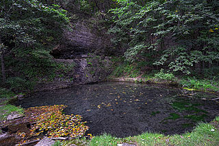
Montauk State Park is a public recreation area occupying nearly 3,000 acres (1,200 ha) at the headwaters of the Current River,fifteen miles (24 km) southwest of Salem,Missouri. The state park contains a fish hatchery and is noted for its rainbow and brown trout angling. It was acquired in 1926. The park has several natural springs including Montauk Springs with a daily average flow of 53 million gallons of water.

Washington State Park is a public recreation area covering 2,147 acres (869 ha) in Washington County in the central eastern part of the state of Missouri. It is located on Highway 21 about 14 miles (23 km) northeast of Potosi or 7 miles (11 km) southwest of De Soto on the eastern edge of the Ozarks. The state park is noted for its Native American rock carvings and for its finely crafted stonework from the 1930s.

Taum Sauk Mountain State Park is a Missouri state park located in the St. Francois Mountains in the Ozarks. The park encompasses Taum Sauk Mountain,the highest point in the state. The Taum Sauk portion of the Ozark Trail connects the park with nearby Johnson's Shut-ins State Park and the Bell Mountain Wilderness Area,which together are part of a large wilderness area popular with hikers and backpackers.

Sam A. Baker State Park is a public recreation area encompassing 5,323 acres (2,154 ha) in the Saint Francois Mountains region of the Missouri Ozarks. The state park offers fishing,canoeing,swimming,camping,and trails for hiking and horseback riding. The visitor and nature center is housed in a historic building that was originally constructed as a stable in 1934. Twenty-five buildings and five structures comprise the Sam A. Baker State Park Historic District,a national historic district listed on the National Register of Historic Places in 1985.

Bennett Spring State Park is a public recreation area located in Bennett Springs,Missouri,twelve miles (19 km) west of Lebanon on Highway 64 in Dallas and Laclede counties. It is centered on the spring that flows into the Niangua River and gives the park its name. The spring averages 100 million gallons of daily flow. The park offers fly fishing,camping,canoeing,hiking,and other activities.

Backbone State Park is Iowa's oldest state park,dedicated in 1919. Located in the valley of the Maquoketa River,it is approximately three miles (5 km) south of Strawberry Point in Delaware County. It is named for a narrow and steep ridge of bedrock carved by a loop of the Maquoketa River originally known as the Devil's Backbone. The initial 1,200 acres (490 ha) were donated by E.M. Carr of Lamont,Iowa. Backbone Lake Dam,a relatively low dam built by the Civilian Conservation Corps (CCC) in the 1930s,created Backbone Lake. The CCC constructed a majority of trails and buildings which make up the park.

Lake of the Ozarks State Park is a public recreation area on the Grand Glaize Arm of the Lake of the Ozarks;it is the largest state park in Missouri. The park includes 85 miles (137 km) of shoreline on the lake;two swimming beaches with imported sand,12 trails,the Ozark Caverns,a boat launch,and the Lee C. Fine Memorial Airport which has a 6,500-foot (2,000 m) runway. In addition there are campsites and cabins within the park.

The Black Moshannon State Park Historic Districts are three separate historic districts on the National Register of Historic Places (NRHP) at Black Moshannon State Park in Rush Township,Centre County,Pennsylvania in the United States. The structures in the historic districts were constructed in the 1930s during the Great Depression by the Civilian Conservation Corps (CCC). The three districts are:the Beach and Day Use District,with 18 contributing structures,including 11 different picnic pavilions,concession building,bathhouse,museum,and four open pit latrines;the Family Cabin District with 16 contributing properties,including 13 cabins,one lodge and two latrines;and the Maintenance District with four contributing properties,including a storage building,three-bay garage,gas pump house,and ranger's residence.

Mark Twain State Park is a public recreation area encompassing 2,788 acres (1,128 ha) on Mark Twain Lake in Monroe County,Missouri. The state park offers water recreation,hiking trails,and campgrounds. It is adjacent to the Mark Twain Birthplace State Historic Site.
Roaring River State Park is a public recreation area covering of 4,294 acres (1,738 ha) eight miles (13 km) south of Cassville in Barry County,Missouri. The state park offers trout fishing on the Roaring River,hiking on seven different trails,and the seasonally open Ozark Chinquapin Nature Center.

Devil's Den State Park is a 2,500-acre (1,000 ha) Arkansas state park in Washington County,near West Fork,Arkansas in the United States. The park was built by the Civilian Conservation Corps,beginning in 1933. Devil's Den State Park is in the Lee Creek Valley in the Boston Mountains,which are the southwestern part of The Ozarks. The park,with an 8 acres (3.2 ha) CCC-built lake,is open for year-round recreation,with trails for hiking,mountain biking and horseback riding. Devil's Den State Park also has several picnic areas,a swimming pool and cabins,with camping sites ranging from modern to primitive. Fossils of coral and crinoids can be found along the banks and within Lee Creek at Devil's Den State Park.

Lake Ahquabi State Park is a state park in Warren County,Iowa,United States,featuring a 115-acre (47 ha) reservoir. Ahquabi means "resting place" in the Fox language. The park is six miles (10 km) south of Indianola and 22 miles (35 km) south of Des Moines. Three sections of the park were listed on the National Register of Historic Places in 1991.

Meramec Conservation Area consists of 3,938 acres (15.94 km2) in southern Franklin County,Missouri. It is located southeast of the town of Sullivan and bordered to the south by Missouri Route 185 and to the west by the Meramec River and Meramec State Park. It is part of the Meramec Greenway,which is over 28,000 acres (110 km2) of public land along the Meramec River.
Architects of the National Park Service are the architects and landscape architects who were employed by the National Park Service (NPS) starting in 1918 to design buildings,structures,roads,trails and other features in the United States National Parks. Many of their works are listed on the National Register of Historic Places,and a number have also been designated as National Historic Landmarks.


