National Register of Historic Places listings in Butler County, Missouri

Last updated

Location of Butler County in Missouri Map of Missouri highlighting Butler County.svg
Location of Butler County in Missouri

This is a list of the National Register of Historic Places listings in Butler County, Missouri.

Contents

This is intended to be a complete list of the properties and districts on the National Register of Historic Places in Butler County, Missouri, United States. Latitude and longitude coordinates are provided for many National Register properties and districts; these locations may be seen together in a map. [1]

There are 25 properties and districts listed on the National Register in the county.


    This National Park Service list is complete through NPS recent listings posted August 18, 2023. [2]

Map all coordinates using: OpenStreetMap

Current listings

[3] Name on the RegisterImageDate listed [4] Location City or townDescription
1 Butler County Courthouse
Butler County Courthouse Butler County Courthouse.JPG
Butler County Courthouse
December 1, 1994
(#94001400)
Public Sq.
36°45′23″N90°23′32″W / 36.756389°N 90.392222°W / 36.756389; -90.392222 (Butler County Courthouse)
Poplar Bluff
2 Cynthia-Kinzer Historic District July 21, 2015
(#15000441)
900-1000 blocks of Cynthia & Kinzer, 918-924 Maud & 838-842 Kinzer Sts.
36°45′40″N90°24′16″W / 36.7612°N 90.4044°W / 36.7612; -90.4044 (Cynthia-Kinzer Historic District)
Poplar Bluff
3 Garfield Historic District
Garfield Historic District Gatlin Grocery Store - Frank and Lutie Jordan House 1.jpg
Garfield Historic District
October 2, 2017
(#100001686)
914-916, 915, 921 Garfield St.
36°45′53″N90°23′50″W / 36.764860°N 90.397183°W / 36.764860; -90.397183 (Garfield Historic District)
Poplar Bluff Includes historic Negro school, a church, and a grocery store/house
4 Alfred W. Greer House
Alfred W. Greer House Alfred W. Greer House.JPG
Alfred W. Greer House
February 12, 1998
(#98000029)
955 Kinzer St.
36°45′39″N90°24′10″W / 36.760833°N 90.402778°W / 36.760833; -90.402778 (Alfred W. Greer House)
Poplar Bluff
5 Hargrove Pivot Bridge
Hargrove Pivot Bridge Hargrove Pivot Bridge.JPG
Hargrove Pivot Bridge
October 15, 1985
(#85003234)
Carries CR 159 over the Black River
36°38′50″N90°18′00″W / 36.647222°N 90.3°W / 36.647222; -90.3 (Hargrove Pivot Bridge)
Poplar Bluff
6 Koehler Fortified Archeological Site December 18, 1970
(#70000323)
Southeastern quarter of Section 36, Township 23 North, Range 4 East [5]
36°35′39″N90°34′48″W / 36.594167°N 90.580000°W / 36.594167; -90.580000 (Koehler Fortified Archeological Site)
Naylor Also known as Powers Fort; [6] a cultural center during Mississippian times [5]
7 Little Black River Archeological District April 21, 1975
(#75001064)
Sharecropper, Harris, and Mackintosh Ridges [5]
36°33′20″N90°32′40″W / 36.555556°N 90.544444°W / 36.555556; -90.544444 (Little Black River Archeological District)
Naylor Hundreds of Mississippian archaeological sites, many of them small [5]
8 Mark Twain School
Mark Twain School Mark Twain School.JPG
Mark Twain School
February 5, 1998
(#98000031)
1012 N. Main St.
36°45′58″N90°24′04″W / 36.766111°N 90.401111°W / 36.766111; -90.401111 (Mark Twain School)
Poplar Bluff
9 J. Herbert Moore House
J. Herbert Moore House J. Herbert Moore House.JPG
J. Herbert Moore House
February 12, 1998
(#98000032)
445 N. Eleventh St.
36°45′40″N90°22′20″W / 36.761111°N 90.372222°W / 36.761111; -90.372222 (J. Herbert Moore House)
Poplar Bluff
10 Thomas Moore House
Thomas Moore House Thomas Moore House.JPG
Thomas Moore House
February 12, 1998
(#98000033)
435 Lester St.
36°45′35″N90°23′39″W / 36.759722°N 90.394167°W / 36.759722; -90.394167 (Thomas Moore House)
Poplar Bluff
11 Moore-Dalton House
Moore-Dalton House Moore-Dalton House.JPG
Moore-Dalton House
December 1, 1994
(#94001398)
421 N. Main St.
36°45′35″N90°23′38″W / 36.759722°N 90.393889°W / 36.759722; -90.393889 (Moore-Dalton House)
Poplar Bluff
12 North Main Street Historic District
North Main Street Historic District 451 N Main St-Poplar Bluff MO.jpg
North Main Street Historic District
July 14, 2011
(#11000440)
400 block of N. Main St.
36°45′38″N90°23′40″W / 36.760556°N 90.394444°W / 36.760556; -90.394444 (North Main Street Historic District)
Poplar Bluff
13 John Archibald Phillips House
John Archibald Phillips House John Archibald Phillips House.jpg
John Archibald Phillips House
February 12, 1998
(#98000034)
522 Cherry St.
36°45′14″N90°23′50″W / 36.753889°N 90.397222°W / 36.753889; -90.397222 (John Archibald Phillips House)
Poplar Bluff
14 Poplar Bluff Commercial Historic District December 1, 1994
(#94001401)
Roughly, S. Broadway from Cedar St. to Vine St. and Vine from Fifth St. to S. Broadway
36°45′21″N90°23′40″W / 36.755833°N 90.394444°W / 36.755833; -90.394444 (Poplar Bluff Commercial Historic District)
Poplar Bluff
15 Poplar Bluff Public Library
Poplar Bluff Public Library Poplar Bluff Public Library.JPG
Poplar Bluff Public Library
December 1, 1994
(#94001399)
318 N. Main St.
36°45′29″N90°23′32″W / 36.758056°N 90.392222°W / 36.758056; -90.392222 (Poplar Bluff Public Library)
Poplar Bluff
16 Rodgers Theatre Building
Rodgers Theatre Building Rodgers Theatre, 204-224 N. Broadway Street, Poplar Bluff, Mo, USA.jpg
Rodgers Theatre Building
July 19, 2001
(#01000750)
204, 214, 216, 218, 220, 222 and 224 N. Broadway
36°45′26″N90°23′36″W / 36.757222°N 90.393333°W / 36.757222; -90.393333 (Rodgers Theatre Building)
Poplar Bluff
17 South Sixth Street Historic District February 12, 1998
(#98000035)
205-225-303 S. Sixth St.
36°45′21″N90°23′50″W / 36.755833°N 90.397222°W / 36.755833; -90.397222 (South Sixth Street Historic District)
Poplar Bluff
18 St. Louis, Iron Mountain and Southern Railroad Depot
St. Louis, Iron Mountain and Southern Railroad Depot Stair0926131303-01.jpg
St. Louis, Iron Mountain and Southern Railroad Depot
December 1, 1994
(#94001397)
400 S. Main St.
36°45′13″N90°23′36″W / 36.753611°N 90.393333°W / 36.753611; -90.393333 (St. Louis, Iron Mountain and Southern Railroad Depot)
Poplar Bluff
19 St. Louis-San Francisco Railroad Depot
St. Louis-San Francisco Railroad Depot Depot0926131257-00.jpg
St. Louis-San Francisco Railroad Depot
December 1, 1994
(#94001396)
303 Moran St.
36°45′15″N90°23′43″W / 36.754167°N 90.395278°W / 36.754167; -90.395278 (St. Louis-San Francisco Railroad Depot)
Poplar Bluff
20 Wheatley Public School
Wheatley Public School Wheatley Public School.JPG
Wheatley Public School
February 13, 1998
(#98000037)
921 Garfield St.
36°45′53″N90°23′49″W / 36.764722°N 90.396944°W / 36.764722; -90.396944 (Wheatley Public School)
Poplar Bluff Historic school for Negro children during Jim Crow era
21 Wilborn-Steinberg Site November 9, 1972
(#72000706)
Northwestern quarter of the southeastern quarter of Section 9, Township 22 North, Range 5 East [5]
36°34′03″N90°31′42″W / 36.567500°N 90.528333°W / 36.567500; -90.528333 (Wilborn-Steinberg Site)
Neelyville
22 Williams-Gierth House
Williams-Gierth House Williams-Gierth House.JPG
Williams-Gierth House
November 6, 2012
(#12000909)
848 Vine St.
36°45′27″N90°24′04″W / 36.757487°N 90.401151°W / 36.757487; -90.401151 (Williams-Gierth House)
Poplar Bluff
23 Williamson-Kennedy School
Williamson-Kennedy School Williamson-Kennedy School.JPG
Williamson-Kennedy School
February 12, 1998
(#98000036)
614 Lindsay St.
36°45′38″N90°23′30″W / 36.760556°N 90.391667°W / 36.760556; -90.391667 (Williamson-Kennedy School)
Poplar Bluff
24 Wright-Dalton-Bell-Anchor Department Store Building
Wright-Dalton-Bell-Anchor Department Store Building Wright-Dalton-Bell-Anchor Department Store Building.JPG
Wright-Dalton-Bell-Anchor Department Store Building
April 12, 2006
(#06000247)
201-205 S. Main
36°45′19″N90°23′36″W / 36.755278°N 90.393333°W / 36.755278; -90.393333 (Wright-Dalton-Bell-Anchor Department Store Building)
Poplar Bluff
25 Zehe Building
Zehe Building Zehe Building.JPG
Zehe Building
December 1, 1994
(#94001402)
203 Poplar St.
36°45′20″N90°23′32″W / 36.755556°N 90.392222°W / 36.755556; -90.392222 (Zehe Building)
Poplar Bluff

See also

Related Research Articles

<span class="mw-page-title-main">National Register of Historic Places listings in Jackson County, Missouri</span>

This is a list of the National Register of Historic Places listings in Jackson County, Missouri.

<span class="mw-page-title-main">National Register of Historic Places listings in Howard County, Missouri</span>

This is a list of the National Register of Historic Places listings in Howard County, Missouri.

<span class="mw-page-title-main">National Register of Historic Places listings in Lafayette County, Missouri</span>

This is a list of the National Register of Historic Places listings in Lafayette County, Missouri.

<span class="mw-page-title-main">National Register of Historic Places listings in Franklin County, Missouri</span>

This is a list of the National Register of Historic Places listings in Franklin County, Missouri.

<span class="mw-page-title-main">National Register of Historic Places listings in Pike County, Missouri</span>

This is a list of the National Register of Historic Places listings in Pike County, Missouri.

<span class="mw-page-title-main">National Register of Historic Places listings in Pettis County, Missouri</span>

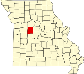
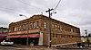
This is a list of the National Register of Historic Places listings in Pettis County, Missouri.

<span class="mw-page-title-main">National Register of Historic Places listings in Marion County, Missouri</span>

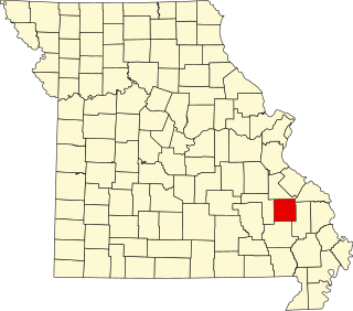
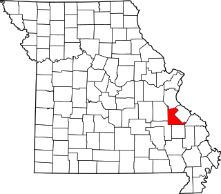
The following properties are listed on the National Register of Historic Places in Marion County, Missouri.

<span class="mw-page-title-main">National Register of Historic Places listings in Lewis County, Missouri</span>

This is a list of the National Register of Historic Places listings in Lewis County, Missouri.

<span class="mw-page-title-main">National Register of Historic Places listings in Carroll County, Missouri</span>

This is a list of the National Register of Historic Places listings in Carroll County, Missouri.

<span class="mw-page-title-main">National Register of Historic Places listings in Wright County, Missouri</span>

This is a list of the National Register of Historic Places listings in Wright County, Missouri.

<span class="mw-page-title-main">National Register of Historic Places listings in Madison County, Missouri</span>

This is a list of the National Register of Historic Places listings in Madison County, Missouri.

<span class="mw-page-title-main">National Register of Historic Places listings in Montgomery County, Missouri</span>

This is a list of the National Register of Historic Places listings in Montgomery County, Missouri.

<span class="mw-page-title-main">National Register of Historic Places listings in St. Francois County, Missouri</span>

This is a list of the National Register of Historic Places listings in St. Francois County, Missouri.

<span class="mw-page-title-main">National Register of Historic Places listings in Henry County, Missouri</span>

This is a list of the National Register of Historic Places listings in Henry County, Missouri.

<span class="mw-page-title-main">National Register of Historic Places listings in Dent County, Missouri</span>

This is a list of the National Register of Historic Places listings in Dent County, Missouri.

<span class="mw-page-title-main">National Register of Historic Places listings in Cass County, Missouri</span>

This is a list of the National Register of Historic Places listings in Cass County, Missouri.

<span class="mw-page-title-main">National Register of Historic Places listings in Sullivan County, Missouri</span>

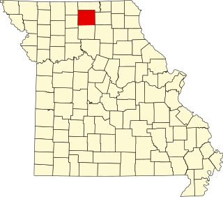
This is a list of the National Register of Historic Places listings in Sullivan County, Missouri.

<span class="mw-page-title-main">National Register of Historic Places listings in Pulaski County, Missouri</span>

This is a list of the National Register of Historic Places listings in Pulaski County, Missouri.

<span class="mw-page-title-main">National Register of Historic Places listings in Linn County, Missouri</span>

This is a list of the National Register of Historic Places listings in Linn County, Missouri.

<span class="mw-page-title-main">National Register of Historic Places listings in Lincoln County, Missouri</span>

This is a list of the National Register of Historic Places listings in Lincoln County, Missouri.

References

  1. The latitude and longitude information provided in this table was derived originally from the National Register Information System, which has been found to be fairly accurate for about 99% of listings. Some locations in this table may have been corrected to current GPS standards.
  2. National Park Service, United States Department of the Interior, "National Register of Historic Places: Weekly List Actions", retrieved August 18, 2023.
  3. Numbers represent an alphabetical ordering by significant words. Various colorings, defined here, differentiate National Historic Landmarks and historic districts from other NRHP buildings, structures, sites or objects.
  4. The eight-digit number below each date is the number assigned to each location in the National Register Information System database, which can be viewed by clicking the number.
  5. 1 2 3 4 5 O'Brien, Michael J. Mississippian Community Organization: The Powers Phase in Southeastern Missouri. New York, Boston, Dordrecht, London, and Moscow: Kluwer Academic/Pluwer, 2001, 87.
  6. "National Register Information System". National Register of Historic Places . National Park Service. July 9, 2010.