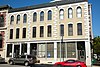
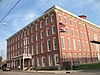
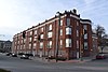
[3] Name on the Register Image Date listed [4] Location City or town Description 1 The Benton Club of St. Joseph The Benton Club of St. Joseph October 2, 2017 (# 100001687 402 N. 7th St. 39°46′09″N 94°51′07″W / 39.769304°N 94.851916°W / 39.769304; -94.851916 (The Benton Club of St. Joseph ) St. Joseph 2 Buchanan County Courthouse Buchanan County Courthouse August 21, 1972 (# 72001563 Courthouse Sq. 39°46′05″N 94°51′20″W / 39.768056°N 94.855556°W / 39.768056; -94.855556 (Buchanan County Courthouse ) St. Joseph Originally listed as both courthouse and jail, but jail removed in a 1978 boundary decrease 3 Buchanan County Infirmary Buchanan County Infirmary January 29, 2009 (# 08001386 3500 N. Village Dr. 39°49′02″N 94°48′41″W / 39.817211°N 94.811347°W / 39.817211; -94.811347 (Buchanan County Infirmary ) St. Joseph 4 Charles A. and Annie Buddy House Charles A. and Annie Buddy House May 14, 2004 (# 04000427 424 S. 9th St. 39°45′49″N 94°50′58″W / 39.763611°N 94.849444°W / 39.763611; -94.849444 (Charles A. and Annie Buddy House ) St. Joseph 5 Burnside-Sandusky Gothic House Burnside-Sandusky Gothic House January 19, 2005 (# 04001518 720 S. 10th St. 39°45′39″N 94°50′53″W / 39.760833°N 94.848056°W / 39.760833; -94.848056 (Burnside-Sandusky Gothic House ) St. Joseph 6 Cathedral Hill Historic District Cathedral Hill Historic District June 15, 2000 (# 00000691 North 9th St., Powell St. and North 13th St. 39°46′22″N 94°50′48″W / 39.772778°N 94.846667°W / 39.772778; -94.846667 (Cathedral Hill Historic District ) St. Joseph 7 Central-North Commercial Historic District Central-North Commercial Historic District March 8, 1991 (# 91000125 Roughly bounded by N. 4th, Main, Francis and Robidoux Sts. 39°46′04″N 94°51′20″W / 39.767778°N 94.855556°W / 39.767778; -94.855556 (Central-North Commercial Historic District ) St. Joseph 8 Central Police Station Central Police Station November 6, 2009 (# 09000887 701 Messanie St. 39°45′45″N 94°51′07″W / 39.762542°N 94.851853°W / 39.762542; -94.851853 (Central Police Station ) St. Joseph 9 Century Apartments Century Apartments July 5, 2001 (# 01000712 627 N. 25th St. 39°46′16″N 94°49′47″W / 39.771111°N 94.829722°W / 39.771111; -94.829722 (Century Apartments ) St. Joseph 10 Christian Sachau Saloon Christian Sachau Saloon October 25, 1985 (# 85003358 1615 Frederick Ave. 39°46′21″N 94°50′26″W / 39.7725°N 94.840556°W / 39.7725; -94.840556 (Christian Sachau Saloon ) St. Joseph 11 City Hose Company No. 9 City Hose Company No. 9 October 25, 1985 (# 85003357 2217 Frederick Ave. 39°46′32″N 94°50′00″W / 39.775556°N 94.833333°W / 39.775556; -94.833333 (City Hose Company No. 9 ) St. Joseph 12 Corby-Forsee Building Corby-Forsee Building March 27, 1980 (# 80002317 5th and Felix Sts. 39°45′59″N 94°51′15″W / 39.766389°N 94.854167°W / 39.766389; -94.854167 (Corby-Forsee Building ) St. Joseph 13 Dewey Avenue-West Rosine Historic District Dewey Avenue-West Rosine Historic District August 1, 2002 (# 02000816 Roughly bound by Prospect Ave., Auguste St., Dewey Avenue and West Rosine St. 39°46′42″N 94°51′39″W / 39.778333°N 94.860833°W / 39.778333; -94.860833 (Dewey Avenue-West Rosine Historic District ) St. Joseph 14 Edmond Jacques Eckel House Upload image January 31, 1980 (# 80002318 515 N. 4th St. 39°46′10″N 94°51′18″W / 39.769444°N 94.855°W / 39.769444; -94.855 (Edmond Jacques Eckel House ) St. Joseph Demolished 15 Everett School Everett School September 15, 2005 (# 05001023 826 S 14th St. 39°45′34″N 94°50′37″W / 39.759444°N 94.843611°W / 39.759444; -94.843611 (Everett School ) St. Joseph 16 Enoch Madison Fenton House Upload image April 12, 1982 (# 82003126 Southeast of Rushville 39°35′41″N 94°58′30″W / 39.594722°N 94.975°W / 39.594722; -94.975 (Enoch Madison Fenton House ) Rushville Demolished. [5] 17 Dr. Jacob Geiger House-Maud Wyeth Painter House Dr. Jacob Geiger House-Maud Wyeth Painter House March 12, 1986 (# 86000826 2501 Frederick Ave. 39°46′37″N 94°49′48″W / 39.776944°N 94.83°W / 39.776944; -94.83 (Dr. Jacob Geiger House-Maud Wyeth Painter House ) St. Joseph 18 German-American Bank Building German-American Bank Building November 24, 1978 (# 78001638 624 Felix St. 39°45′59″N 94°51′07″W / 39.766389°N 94.851944°W / 39.766389; -94.851944 (German-American Bank Building ) St. Joseph 19 Hall School Hall School January 31, 2017 (# 100000607 2509 Duncan St. 39°45′06″N 94°49′47″W / 39.751720°N 94.829678°W / 39.751720; -94.829678 (Hall School ) St. Joseph 20 Hall Street Historic District Hall Street Historic District July 17, 1979 (# 79001352 Roughly bounded by Isadore, Corby, 6th and 9th Sts. 39°46′20″N 94°51′04″W / 39.772222°N 94.851111°W / 39.772222; -94.851111 (Hall Street Historic District ) St. Joseph 21 Harris Addition Historic District Harris Addition Historic District January 13, 2003 (# 01000723 Roughly bounded by 16th St, Dalton St., 22nd St. and Edmond St. 39°46′04″N 94°50′17″W / 39.767778°N 94.838056°W / 39.767778; -94.838056 (Harris Addition Historic District ) St. Joseph 22 Alois Herbert Double House Alois Herbert Double House May 29, 2007 (# 06000992 620 S. 10th St. 39°45′50″N 94°50′54″W / 39.763889°N 94.848333°W / 39.763889; -94.848333 (Alois Herbert Double House ) St. Joseph 23 Jesse James House Jesse James House September 4, 1980 (# 80002319 12th St. and Mitchell Ave. 39°45′20″N 94°50′43″W / 39.755556°N 94.845278°W / 39.755556; -94.845278 (Jesse James House ) St. Joseph 24 Kelley and Browne Flats Kelley and Browne Flats August 3, 1989 (# 89000991 1208-1216 Frederick Ave. 39°46′12″N 94°50′41″W / 39.77°N 94.844722°W / 39.77; -94.844722 (Kelley and Browne Flats ) St. Joseph 25 Kemper Addition Historic District Kemper Addition Historic District September 20, 2002 (# 01000721 Portions of Clay, Union, Kemper and Bon Ton Sts. 39°46′19″N 94°50′11″W / 39.771944°N 94.836389°W / 39.771944; -94.836389 (Kemper Addition Historic District ) St. Joseph 26 King's Hill Archeological Site Upload image April 16, 1969 (# 69000091 Western end of King Hill Dr. [6] 39°43′08″N 94°51′33″W / 39.718889°N 94.859167°W / 39.718889; -94.859167 (King's Hill Archeological Site ) St. Joseph 27 Krug Park Place Historic District Krug Park Place Historic District August 1, 2002 (# 02000817 Roughly bounded by St. Joseph Ave., Myrtle St., Clark St., and Magnolia Ave. 39°47′30″N 94°50′47″W / 39.791667°N 94.846389°W / 39.791667; -94.846389 (Krug Park Place Historic District ) St. Joseph 28 Lawler Motor Company Building Lawler Motor Company Building January 8, 2009 (# 08001285 1224 Frederick Ave. 39°46′12″N 94°50′42″W / 39.770086°N 94.844978°W / 39.770086; -94.844978 (Lawler Motor Company Building ) St. Joseph 29 Livestock Exchange Building Livestock Exchange Building April 20, 2004 (# 04000342 601 Illinois Ave. 39°43′14″N 94°52′10″W / 39.720556°N 94.869444°W / 39.720556; -94.869444 (Livestock Exchange Building ) St. Joseph 30 John Sublett Jr. and Caroline Ashton Logan House John Sublett Jr. and Caroline Ashton Logan House May 7, 2007 (# 06000991 1906 N. 22nd St. 39°47′10″N 94°50′05″W / 39.786111°N 94.834722°W / 39.786111; -94.834722 (John Sublett Jr. and Caroline Ashton Logan House ) St. Joseph 31 Maple Grove Maple Grove October 16, 1974 (# 74001070 2100 N. 11th St. 39°47′05″N 94°50′46″W / 39.784722°N 94.846111°W / 39.784722; -94.846111 (Maple Grove ) St. Joseph 32 McIntyre-Burri House McIntyre-Burri House December 23, 2005 (# 05001435 808 N. 24th St. 39°46′35″N 94°49′54″W / 39.776389°N 94.831667°W / 39.776389; -94.831667 (McIntyre-Burri House ) St. Joseph 33 Isaac Miller House Isaac Miller House September 17, 1980 (# 80002320 3003 Ashland Ave. 39°47′46″N 94°49′04″W / 39.796111°N 94.817778°W / 39.796111; -94.817778 (Isaac Miller House ) St. Joseph 34 Miller-Porter-Lacy House Miller-Porter-Lacy House September 9, 1982 (# 82003127 2912 Frederick Blvd. 39°46′34″N 94°49′14″W / 39.776111°N 94.820556°W / 39.776111; -94.820556 (Miller-Porter-Lacy House ) St. Joseph 35 Missouri Theater and Missouri Theater Building Missouri Theater and Missouri Theater Building October 11, 1979 (# 79001353 112-128 S. 8th St. and 713-721 Edmond St. 39°45′58″N 94°51′02″W / 39.766111°N 94.850556°W / 39.766111; -94.850556 (Missouri Theater and Missouri Theater Building ) St. Joseph 36 Missouri Valley Trust Company Historic District Missouri Valley Trust Company Historic District March 4, 1975 (# 75001063 Felix and 4th Sts. 39°46′00″N 94°51′21″W / 39.766667°N 94.855833°W / 39.766667; -94.855833 (Missouri Valley Trust Company Historic District ) St. Joseph 37 Mount Mora Cemetery Mount Mora Cemetery July 19, 2006 (# 06000626 824 Mount Mora Rd. 39°46′39″N 94°50′31″W / 39.7775°N 94.841944°W / 39.7775; -94.841944 (Mount Mora Cemetery ) St. Joseph 38 Museum Hill Historic District Museum Hill Historic District March 8, 1991 (# 91000112 Roughly bounded by 9th, Francis, 12th, Jules, 15th and Messanie Sts.; also 321 and 323 N. 15th and 1510 Faraon St. 39°45′56″N 94°50′43″W / 39.765556°N 94.845278°W / 39.765556; -94.845278 (Museum Hill Historic District ) St. Joseph Second set of addresses represents a boundary increase of August 5, 2009 39 Neely Elementary School Neely Elementary School June 23, 2014 (# 14000328 1909 S. 12th St. 39°44′57″N 94°50′43″W / 39.7492°N 94.8452°W / 39.7492; -94.8452 (Neely Elementary School ) St. Joseph 40 Nelson-Pettis Farmsteads Historic District Nelson-Pettis Farmsteads Historic District May 11, 1995 (# 95000587 4401 Ajax Rd., 3412 Pettis Rd. 39°43′23″N 94°48′37″W / 39.723056°N 94.810278°W / 39.723056; -94.810278 (Nelson-Pettis Farmsteads Historic District ) St. Joseph 41 Patee Town Historic District Upload image August 1, 2002 (# 02000818 Roughly bounded by Penn St., S. 11th St., Lafayette St. and S. 15th St. 39°45′33″N 94°50′36″W / 39.759167°N 94.843333°W / 39.759167; -94.843333 (Patee Town Historic District ) St. Joseph 42 John Patee House John Patee House October 15, 1966 (# 66000414 12th and Penn Sts. 39°45′21″N 94°50′42″W / 39.755833°N 94.845°W / 39.755833; -94.845 (John Patee House ) St. Joseph 43 Pleasant Ridge School Upload image May 2, 1985 (# 85000941 R.F.D. #4 (MO State Rte 371) 39°40′57″N 94°49′50″W / 39.6825°N 94.830556°W / 39.6825; -94.830556 (Pleasant Ridge School ) St. Joseph Destroyed 44 Pony Express Stables Pony Express Stables April 3, 1970 (# 70000322 914 Penn St. 39°45′22″N 94°50′57″W / 39.756111°N 94.849167°W / 39.756111; -94.849167 (Pony Express Stables ) St. Joseph Stables at the eastern terminus of the Pony Express 45 John D. Richardson Dry Goods Company John D. Richardson Dry Goods Company April 12, 1982 (# 82003128 300 N. 3rd St. 39°46′07″N 94°51′25″W / 39.768611°N 94.856944°W / 39.768611; -94.856944 (John D. Richardson Dry Goods Company ) St. Joseph 46 Robidoux Hill Historic District Robidoux Hill Historic District August 3, 1989 (# 89000992 Roughly bounded by Franklin St., Robidoux St., Fourth St., Louis St., and Fifth St. 39°46′19″N 94°51′17″W / 39.771944°N 94.854722°W / 39.771944; -94.854722 (Robidoux Hill Historic District ) St. Joseph 47 Robidoux Row Robidoux Row March 7, 1973 (# 73001037 219-225 E. Poulin St. 39°46′29″N 94°51′27″W / 39.774722°N 94.8575°W / 39.774722; -94.8575 (Robidoux Row ) St. Joseph 48 Robidoux School Robidoux School August 11, 1983 (# 83000973 201 S. 10th St. 39°45′24″N 94°50′51″W / 39.756667°N 94.8475°W / 39.756667; -94.8475 (Robidoux School ) St. Joseph 49 Ryan Block Ryan Block January 29, 2013 (# 12001242 1137-1141 Frederick Ave. 39°46′12″N 94°50′43″W / 39.77002°N 94.845403°W / 39.77002; -94.845403 (Ryan Block ) St. Joseph 50 St. Joseph City Hall St. Joseph City Hall October 25, 1985 (# 85003356 Frederick Ave. at Eleventh St. 39°46′07″N 94°50′47″W / 39.768611°N 94.846389°W / 39.768611; -94.846389 (St. Joseph City Hall ) St. Joseph 51 St. Joseph Park and Parkway System St. Joseph Park and Parkway System January 20, 1995 (# 94001566 Roughly, along Northwest, Northeast, Corby Grove, Southwest and A Pkwys. and Noyes Blvd. from Krug Park to Hyde Park 39°45′04″N 94°50′25″W / 39.751111°N 94.840278°W / 39.751111; -94.840278 (St. Joseph Park and Parkway System ) St. Joseph 52 St. Joseph Public Library St. Joseph Public Library September 20, 1982 (# 82003129 10th and Felix Sts. 39°46′00″N 94°50′53″W / 39.766667°N 94.848056°W / 39.766667; -94.848056 (St. Joseph Public Library ) St. Joseph 53 St. Joseph Public Library-Carnegie Branch St. Joseph Public Library-Carnegie Branch May 20, 1999 (# 99000595 316 Massachusetts St. 39°42′58″N 94°51′58″W / 39.716111°N 94.866111°W / 39.716111; -94.866111 (St. Joseph Public Library-Carnegie Branch ) St. Joseph 54 St. Joseph's Commerce and Banking Historic District St. Joseph's Commerce and Banking Historic District July 5, 2001 (# 01000709 Roughly bounded by 3rd, 91t, Francis, and Edmonds St. 39°45′59″N 94°51′09″W / 39.766389°N 94.8525°W / 39.766389; -94.8525 (St. Joseph's Commerce and Banking Historic District ) St. Joseph 55 South Fourth Street Commercial Historic District South Fourth Street Commercial Historic District March 8, 1991 (# 91000124 Roughly bounded by S. 3rd, S. 5th, Charles and Messanie Sts. 39°45′50″N 94°51′22″W / 39.763889°N 94.856111°W / 39.763889; -94.856111 (South Fourth Street Commercial Historic District ) St. Joseph 56 Sugar Lake State Park Open Shelter Sugar Lake State Park Open Shelter February 28, 1985 (# 85000522 Off MO 138 39°32′21″N 95°03′35″W / 39.539167°N 95.059722°W / 39.539167; -95.059722 (Sugar Lake State Park Open Shelter ) Rushville A shelter at Sugar Lake, now Lewis and Clark State Park 57 Thompson-Brown-Sandusky House Thompson-Brown-Sandusky House February 10, 1983 (# 83004297 207 E. Cliff St. 39°42′33″N 94°51′36″W / 39.709167°N 94.86°W / 39.709167; -94.86 (Thompson-Brown-Sandusky House ) St. Joseph 58 Virginia Flats Virginia Flats May 21, 1992 (# 92000586 516-518 and 520-528 N. 10th St. 39°46′14″N 94°50′54″W / 39.770556°N 94.848333°W / 39.770556; -94.848333 (Virginia Flats ) St. Joseph 59 Vosteen-Hauck House Upload image September 23, 1982 (# 82003130 913 N. 2nd St. 39°46′24″N 94°51′28″W / 39.773333°N 94.857778°W / 39.773333; -94.857778 (Vosteen-Hauck House ) St. Joseph Demolished 60 Western Tablet and Stationery Company, Building No. 2 Western Tablet and Stationery Company, Building No. 2 August 16, 2007 (# 07000814 1300 S 12th St. 39°45′24″N 94°50′45″W / 39.756667°N 94.845833°W / 39.756667; -94.845833 (Western Tablet and Stationery Company, Building No. 2 ) St. Joseph 61 Wholesale Row Wholesale Row September 19, 1977 (# 77000800 Bounded by Jules, 3rd, 4th, and Francis Sts. 39°46′04″N 94°51′23″W / 39.767778°N 94.856389°W / 39.767778; -94.856389 (Wholesale Row ) St. Joseph Noyes-Norman Bldg on 3rd St demolished, remaining 4 bldgs. along 3rd still extant 62 Wyeth Flats Wyeth Flats October 25, 1985 (# 85003355 1015-1031 Faraon St. 39°46′09″N 94°50′48″W / 39.769167°N 94.846667°W / 39.769167; -94.846667 (Wyeth Flats ) St. Joseph