National Register of Historic Places listings in Barry County, Missouri

Last updated

Location of Barry County in Missouri Map of Missouri highlighting Barry County.svg
Location of Barry County in Missouri

This is a list of the National Register of Historic Places listings in Barry County, Missouri.

Contents

This is intended to be a complete list of the properties and districts on the National Register of Historic Places in Barry County, Missouri, United States. Latitude and longitude coordinates are provided for many National Register properties and districts; these locations may be seen together in a map. [1]

There are 17 properties and districts listed on the National Register in the county.


    This National Park Service list is complete through NPS recent listings posted January 5, 2024. [2]

Map all coordinates using: OpenStreetMap

Current listings

[3] Name on the RegisterImageDate listed [4] Location City or townDescription
1 Camp Smokey/Company 1713 Historic District February 26, 1985
(#85000513)
Off Park Rd.
36°34′43″N93°49′30″W / 36.578611°N 93.825°W / 36.578611; -93.825 (Camp Smokey/Company 1713 Historic District)
Cassville
2 Cassville Ranger Station Historic District August 4, 2003
(#03000716)
MO 248
36°40′23″N93°51′32″W / 36.673056°N 93.858889°W / 36.673056; -93.858889 (Cassville Ranger Station Historic District)
Cassville
3 David W. Courdin House November 5, 1971
(#71000460)
2.4 miles SE of Monett
36°54′01″N93°54′26″W / 36.900278°N 93.907222°W / 36.900278; -93.907222 (David W. Courdin House)
Monett
4 Downtown Monett Historic District June 27, 2014
(#14000373)
Parts of the 200-400 blocks of Broadway & Bond
36°55′16″N93°55′28″W / 36.9210°N 93.9245°W / 36.9210; -93.9245 (Downtown Monett Historic District)
Monett
5 McMurtry Spring and Trail of Tears Roadbed Segment July 23, 2018
(#16000366)
Address Restricted
Cassville vicinity
6 Natural Bridge Archeological Site May 5, 1972
(#72000704)
Address Restricted
Cassville
7 Roaring River Camps and Hotel Summer Cottage January 4, 2024
(#100009689)
24895 Farm Rd. 1135
36°35′25″N93°50′03″W / 36.5904°N 93.8343°W / 36.5904; -93.8343 (Roaring River Camps and Hotel Summer Cottage)
Cassville vicinity
8 Roaring River State Park Bath House March 4, 1985
(#85000500)
Off Park Rd.
36°34′46″N93°49′49″W / 36.579444°N 93.830278°W / 36.579444; -93.830278 (Roaring River State Park Bath House)
Cassville
9 Roaring River State Park Dam/Spillway
Roaring River State Park Dam/Spillway Roaring River State Park Dam and Spillway.jpg
Roaring River State Park Dam/Spillway
February 28, 1985
(#85000518)
Off Park Rd.
36°35′29″N93°50′00″W / 36.591389°N 93.833333°W / 36.591389; -93.833333 (Roaring River State Park Dam/Spillway)
Cassville
10 Roaring River State Park Deer Leap Trail
Roaring River State Park Deer Leap Trail Deer Leap Trail.jpg
Roaring River State Park Deer Leap Trail
February 26, 1985
(#85000519)
Off Park Rd.
36°35′30″N93°49′56″W / 36.591667°N 93.832222°W / 36.591667; -93.832222 (Roaring River State Park Deer Leap Trail)
Cassville
11 Roaring River State Park Honeymoon Cabin February 26, 1985
(#85000520)
Off Park Rd.
36°35′N93°50′W / 36.58°N 93.83°W / 36.58; -93.83 (Roaring River State Park Honeymoon Cabin)
Cassville
12 Roaring River State Park Hotel March 4, 1985
(#85000501)
Off Park Rd.
36°35′25″N93°50′02″W / 36.590278°N 93.833889°W / 36.590278; -93.833889 (Roaring River State Park Hotel)
Cassville
13 Roaring River State Park Shelter Kitchen No. 2 and Rest Room February 26, 1985
(#85000521)
Off Park Rd.
36°35′01″N93°50′07″W / 36.583611°N 93.835278°W / 36.583611; -93.835278 (Roaring River State Park Shelter Kitchen No. 2 and Rest Room)
Cassville
14 Southwest Missouri Prehistoric Rock Shelter and Cave Sites Discontiguous Archeological District October 24, 1991
(#91002046)
1 mile (1.6 km) east of Mineral Spring at the source of Rockhouse Creek [5]
36°40′08″N93°44′57″W / 36.668889°N 93.749167°W / 36.668889; -93.749167 (Southwest Missouri Prehistoric Rock Shelter and Cave Sites Discontiguous Archeological District)
Cato Location is for Rockhouse Cave (23BY3), a part of the district
15 Tom Town Historic District December 15, 1989
(#89002126)
Off County Road VV, S of Pleasant Ridge
36°52′12″N93°48′35″W / 36.87°N 93.809722°W / 36.87; -93.809722 (Tom Town Historic District)
Pleasant Ridge
16 Waldensian Church and Cemetery of Stone Prairie January 18, 1985
(#85000100)
Rt. 2
36°53′48″N93°55′07″W / 36.896667°N 93.918611°W / 36.896667; -93.918611 (Waldensian Church and Cemetery of Stone Prairie)
Monett
17 Wheaton Missouri and North Arkansas Railroad Depot February 10, 2000
(#00000085)
Junction of Main and Barnett Sts.
36°45′48″N94°03′15″W / 36.763333°N 94.054167°W / 36.763333; -94.054167 (Wheaton Missouri and North Arkansas Railroad Depot)
Wheaton

See also

Related Research Articles

<span class="mw-page-title-main">National Register of Historic Places listings in Howard County, Missouri</span>

This is a list of the National Register of Historic Places listings in Howard County, Missouri.

<span class="mw-page-title-main">National Register of Historic Places listings in Pike County, Missouri</span>

This is a list of the National Register of Historic Places listings in Pike County, Missouri.

<span class="mw-page-title-main">National Register of Historic Places listings in Macon County, Missouri</span>

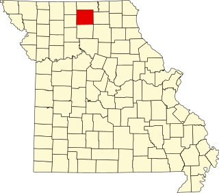
This is a list of the National Register of Historic Places listings in Macon County, Missouri.

<span class="mw-page-title-main">National Register of Historic Places listings in Perry County, Missouri</span>

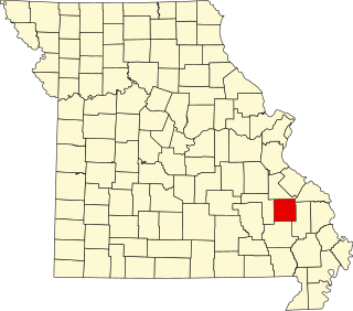
This is a list of the National Register of Historic Places listings in Perry County, Missouri.

<span class="mw-page-title-main">National Register of Historic Places listings in Marion County, Missouri</span>

The following properties are listed on the National Register of Historic Places in Marion County, Missouri.

<span class="mw-page-title-main">National Register of Historic Places listings in Miller County, Missouri</span>

This is a list of the National Register of Historic Places listings in Miller County, Missouri.

<span class="mw-page-title-main">National Register of Historic Places listings in Cole County, Missouri</span>

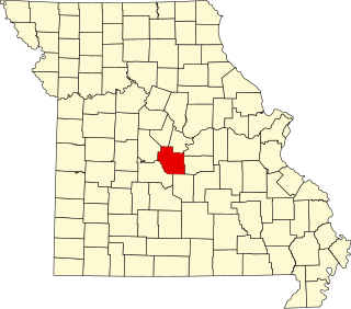
This is a list of the National Register of Historic Places listings in Cole County, Missouri.

<span class="mw-page-title-main">National Register of Historic Places listings in Carroll County, Missouri</span>

This is a list of the National Register of Historic Places listings in Carroll County, Missouri.

<span class="mw-page-title-main">National Register of Historic Places listings in Wright County, Missouri</span>

This is a list of the National Register of Historic Places listings in Wright County, Missouri.

<span class="mw-page-title-main">National Register of Historic Places listings in Phelps County, Missouri</span>

This is a list of the National Register of Historic Places listings in Phelps County, Missouri.

<span class="mw-page-title-main">National Register of Historic Places listings in Madison County, Missouri</span>

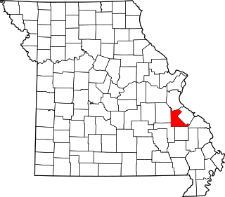
This is a list of the National Register of Historic Places listings in Madison County, Missouri.

<span class="mw-page-title-main">National Register of Historic Places listings in Montgomery County, Missouri</span>

This is a list of the National Register of Historic Places listings in Montgomery County, Missouri.

<span class="mw-page-title-main">National Register of Historic Places listings in St. Francois County, Missouri</span>

This is a list of the National Register of Historic Places listings in St. Francois County, Missouri.

<span class="mw-page-title-main">National Register of Historic Places listings in Mississippi County, Missouri</span>

This is a list of the National Register of Historic Places listings in Mississippi County, Missouri.

<span class="mw-page-title-main">National Register of Historic Places listings in Henry County, Missouri</span>

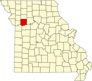
This is a list of the National Register of Historic Places listings in Henry County, Missouri.

<span class="mw-page-title-main">National Register of Historic Places listings in Cass County, Missouri</span>

This is a list of the National Register of Historic Places listings in Cass County, Missouri.

<span class="mw-page-title-main">National Register of Historic Places listings in Ray County, Missouri</span>

This is a list of the National Register of Historic Places listings in Ray County, Missouri.

<span class="mw-page-title-main">National Register of Historic Places listings in Sullivan County, Missouri</span>

This is a list of the National Register of Historic Places listings in Sullivan County, Missouri.

<span class="mw-page-title-main">National Register of Historic Places listings in Pulaski County, Missouri</span>

This is a list of the National Register of Historic Places listings in Pulaski County, Missouri.

<span class="mw-page-title-main">National Register of Historic Places listings in Linn County, Missouri</span>

This is a list of the National Register of Historic Places listings in Linn County, Missouri.

References

  1. The latitude and longitude information provided in this table was derived originally from the National Register Information System, which has been found to be fairly accurate for about 99% of listings. Some locations in this table may have been corrected to current GPS standards.
  2. National Park Service, United States Department of the Interior, "National Register of Historic Places: Weekly List Actions", retrieved January 5, 2024.
  3. Numbers represent an alphabetical ordering by significant words. Various colorings, defined here, differentiate National Historic Landmarks and historic districts from other NRHP buildings, structures, sites or objects.
  4. The eight-digit number below each date is the number assigned to each location in the National Register Information System database, which can be viewed by clicking the number.
  5. Adams, Lee. "Rockhouse Cave". Missouri Archaeologist 7.2 (1941): 18-27: 19.