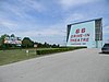
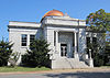
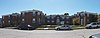
[3] Name on the Register Image Date listed [4] Location City or town Description 1 66 Drive-In 66 Drive-In April 2, 2003 (# 03000182 17231 Old 66 Boulevard 37°10′24″N 94°22′06″W / 37.173333°N 94.368333°W / 37.173333; -94.368333 (66 Drive-In ) Carthage 2 Bank of Avilla Upload image March 7, 2022 (# 100007497 205 Greenfield St. 37°11′45″N 94°07′48″W / 37.1958°N 94.1299°W / 37.1958; -94.1299 (Bank of Avilla ) Avilla 3 Boots Court Boots Court September 26, 2022 (# 100008202 107 South Garrison Ave. 37°10′42″N 94°18′51″W / 37.1783°N 94.3141°W / 37.1783; -94.3141 (Boots Court ) Carthage 4 Lucius P. Buchanan House Upload image August 22, 2016 (# 16000546 3708 E. University Pkwy. 37°05′49″N 94°27′52″W / 37.097040°N 94.464357°W / 37.097040; -94.464357 (Lucius P. Buchanan House ) Joplin Now the Ralph L. Gray Alumni Center of Missouri Southern State University 5 Carthage Courthouse Square Historic District Carthage Courthouse Square Historic District May 15, 1980 (# 80002370 Roughly bounded by E. Central Ave., S. Maple, Lincoln, and W. 5th Sts. 37°10′36″N 94°18′37″W / 37.176667°N 94.310278°W / 37.176667; -94.310278 (Carthage Courthouse Square Historic District ) Carthage 6 Carthage South Historic District Carthage South Historic District May 6, 1982 (# 82004915 City limits of Carthage 37°10′08″N 94°18′38″W / 37.168889°N 94.310556°W / 37.168889; -94.310556 (Carthage South Historic District ) Carthage 7 Cassill Place Historic District Cassill Place Historic District January 2, 1986 (# 86000005 Roughly the first half-block of W. Central east of Blanche St. 37°10′44″N 94°19′13″W / 37.178889°N 94.320278°W / 37.178889; -94.320278 (Cassill Place Historic District ) Carthage 8 Cave Spring School and Cave Spring Cemetery Upload image July 17, 2012 (# 12000416 4323 Cty. Rd. 4 37°06′43″N 94°03′45″W / 37.111812°N 94.062518°W / 37.111812; -94.062518 (Cave Spring School and Cave Spring Cemetery ) Sarcoxie 9 Cleveland Apartments Upload image December 23, 2021 (# 100007261 801-807 West 1st St. and 104 North Jackson Ave. 37°05′27″N 94°31′17″W / 37.0909°N 94.5215°W / 37.0909; -94.5215 (Cleveland Apartments ) Joplin 10 Colonial Apartments Colonial Apartments August 14, 2001 (# 01000835 406 Walnut St. 37°10′29″N 94°18′51″W / 37.174722°N 94.314167°W / 37.174722; -94.314167 (Colonial Apartments ) Carthage 11 Downtown Webb City Historic District Downtown Webb City Historic District July 18, 2014 (# 14000427 Roughly N. and S. Main, E. and W. Broadway, Daugherty, E. Church, N. Tom, N. Liberty, and N. and S. Webb 37°08′48″N 94°27′50″W / 37.1466°N 94.4638°W / 37.1466; -94.4638 (Downtown Webb City Historic District ) Webb City 12 Elks Club Lodge No. 501 Elks Club Lodge No. 501 June 3, 1985 (# 85001188 318-320 W. 4th St. 37°05′15″N 94°30′58″W / 37.0875°N 94.516111°W / 37.0875; -94.516111 (Elks Club Lodge No. 501 ) Joplin 13 Fifth and Main Historic District Fifth and Main Historic District July 5, 2006 (# 06000541 501-513 S. Main St., 502-508 Virginia St. 37°05′19″N 94°30′48″W / 37.088611°N 94.513333°W / 37.088611; -94.513333 (Fifth and Main Historic District ) Joplin 14 Fox Theater Fox Theater July 30, 1990 (# 90001100 415 S. Main St. 37°05′18″N 94°30′51″W / 37.088333°N 94.514167°W / 37.088333; -94.514167 (Fox Theater ) Joplin 15 Gentry Apartments Gentry Apartments August 8, 2006 (# 06000683 318 S. Wall St. 37°05′23″N 94°30′57″W / 37.089722°N 94.515833°W / 37.089722; -94.515833 (Gentry Apartments ) Joplin 16 Inter-State Grocer Company Building Inter-State Grocer Company Building October 24, 2008 (# 08001024 1027-1035 S. Main St. 37°04′45″N 94°30′48″W / 37.079167°N 94.513333°W / 37.079167; -94.513333 (Inter-State Grocer Company Building ) Joplin 17 Jasper County Courthouse Jasper County Courthouse February 8, 1973 (# 73001041 Courthouse Sq. 37°10′45″N 94°18′37″W / 37.179167°N 94.310278°W / 37.179167; -94.310278 (Jasper County Courthouse ) Carthage 18 Joplin and Wall Avenues Historic District Upload image October 12, 2010 (# 10000819 Portions of S. Joplin and Wall Aves., W. First, Second, Third Sts. 37°05′23″N 94°30′53″W / 37.089722°N 94.514722°W / 37.089722; -94.514722 (Joplin and Wall Avenues Historic District ) Joplin 19 Joplin Carnegie Library Joplin Carnegie Library July 10, 1979 (# 79001377 9th and Wall Sts. 37°04′55″N 94°30′57″W / 37.081944°N 94.515833°W / 37.081944; -94.515833 (Joplin Carnegie Library ) Joplin 20 Joplin Connor Hotel Upload image February 28, 1973 (# 73001042 324 Main St. 37°05′17″N 94°30′49″W / 37.088056°N 94.513611°W / 37.088056; -94.513611 (Joplin Connor Hotel ) Joplin Demolished. [5] 21 Joplin Downtown Historic District Joplin Downtown Historic District July 16, 2008 (# 08000661 S. Main St., roughly between E. 4th and E. 6th Sts. 37°05′12″N 94°30′48″W / 37.086667°N 94.513333°W / 37.086667; -94.513333 (Joplin Downtown Historic District ) Joplin 22 Joplin East Town Historic District Upload image November 2, 2022 (# 100008307 Roughly bounded by Broadway Langston Hughes, Landreth Ave., Hill St., and Division Ave 37°05′31″N 94°30′22″W / 37.0919°N 94.5061°W / 37.0919; -94.5061 (Joplin East Town Historic District ) Joplin 23 Joplin Furniture Company Building Upload image August 7, 2012 (# 12000473 702-708 Main St. 37°05′02″N 94°30′49″W / 37.083812°N 94.513655°W / 37.083812; -94.513655 (Joplin Furniture Company Building ) Joplin 24 Joplin Supply Company Joplin Supply Company July 3, 2007 (# 07000652 228 S. Joplin Ave. 37°05′20″N 94°30′52″W / 37.088889°N 94.514444°W / 37.088889; -94.514444 (Joplin Supply Company ) Joplin 25 Joplin Union Depot Joplin Union Depot March 14, 1973 (# 73001043 Broadway and Main St. 37°05′30″N 94°30′42″W / 37.0917°N 94.5117°W / 37.0917; -94.5117 (Joplin Union Depot ) Joplin 26 Joplin YMCA Upload image January 19, 2022 (# 100007358 510 South Wall Ave. 37°05′12″N 94°30′57″W / 37.0866°N 94.5157°W / 37.0866; -94.5157 (Joplin YMCA ) Joplin 27 Main and Eighth Streets Historic District Main and Eighth Streets Historic District April 15, 2011 (# 11000185 Portions of the 800 and 900 block of S. Main St. 37°04′53″N 94°30′49″W / 37.0814°N 94.5136°W / 37.0814; -94.5136 (Main and Eighth Streets Historic District ) Joplin 28 Memorial Hall Upload image October 7, 2021 (# 100007039 212 West 8th St. 37°04′58″N 94°30′55″W / 37.0828°N 94.5152°W / 37.0828; -94.5152 (Memorial Hall ) Joplin 29 Middle West Hotel Middle West Hotel September 16, 1982 (# 82003149 1 S. Main St. 37°08′46″N 94°27′45″W / 37.1461°N 94.4625°W / 37.1461; -94.4625 (Middle West Hotel ) Webb City 30 Murphysburg Historic District Upload image May 18, 2015 (# 15000228 Roughly bounded by S. Sergeant, S. Pearl & S. Byers Aves., W. 1st, W. 4th & W. 7th Sts. 37°05′08″N 94°31′05″W / 37.0856°N 94.5180°W / 37.0856; -94.5180 (Murphysburg Historic District ) Joplin 31 Newman Brothers Building Newman Brothers Building July 23, 1990 (# 90001101 602-608 S. Main St. 37°05′07″N 94°30′45″W / 37.0853°N 94.5125°W / 37.0853; -94.5125 (Newman Brothers Building ) Joplin 32 Olivia Apartments Olivia Apartments June 20, 2008 (# 08000536 320 Moffet Ave. 37°05′19″N 94°31′08″W / 37.0886°N 94.5189°W / 37.0886; -94.5189 (Olivia Apartments ) Joplin 33 Pennington Drug Company Upload image October 10, 2017 (# 100001742 512-520 Virginia Ave. 37°05′10″N 94°30′44″W / 37.0861°N 94.5123°W / 37.0861; -94.5123 (Pennington Drug Company ) Joplin 34 Phelps Country Estate Phelps Country Estate August 29, 1983 (# 83001023 RR 1, Newcastle Rd. just west of CR100 37°15′00″N 94°14′10″W / 37.25°N 94.2361°W / 37.25; -94.2361 (Phelps Country Estate ) Carthage 35 Rains Brothers Building Rains Brothers Building July 19, 1990 (# 90001102 906-908 S. Main St. 37°04′52″N 94°30′44″W / 37.0811°N 94.5122°W / 37.0811; -94.5122 (Rains Brothers Building ) Joplin Destroyed by fire March 1, 2012 [6] 36 Ridgway Apartments Ridgway Apartments August 8, 2006 (# 06000682 402 S. Byers Ave. and 404 S. Byers Ave. 37°05′22″N 94°31′05″W / 37.0894°N 94.5181°W / 37.0894; -94.5181 (Ridgway Apartments ) Joplin 37 St. Louis and San Francisco Railroad Building St. Louis and San Francisco Railroad Building October 22, 2002 (# 02001193 605 Main St. 37°05′09″N 94°30′47″W / 37.0858°N 94.5131°W / 37.0858; -94.5131 (St. Louis and San Francisco Railroad Building ) Joplin 38 St. Peter the Apostle Catholic Church and Rectory St. Peter the Apostle Catholic Church and Rectory June 28, 1991 (# 91000851 812 Pearl St. 37°04′58″N 94°31′01″W / 37.0828°N 94.5169°W / 37.0828; -94.5169 (St. Peter the Apostle Catholic Church and Rectory ) Joplin 39 Sarcoxie Public Square Historic District Upload image October 20, 2014 (# 14000872 Along 5th, 6th, Center & Cross Sts. 37°04′09″N 94°07′00″W / 37.0693°N 94.1167°W / 37.0693; -94.1167 (Sarcoxie Public Square Historic District ) Sarcoxie 40 Scottish Rite Cathedral Scottish Rite Cathedral June 21, 1990 (# 90000989 505 Byers Ave. 37°05′11″N 94°31′02″W / 37.0864°N 94.5172°W / 37.0864; -94.5172 (Scottish Rite Cathedral ) Joplin 41 South Main Street Historic District South Main Street Historic District October 12, 2010 (# 10000818 Western side of S. Main St., between W. First and W. Second Sts. 37°05′24″N 94°30′48″W / 37.09°N 94.5133°W / 37.09; -94.5133 (South Main Street Historic District ) Joplin 42 Elijah Thomas Webb House Elijah Thomas Webb House July 20, 2020 (# 100005346 4 South Liberty St. 37°08′45″N 94°27′55″W / 37.1459°N 94.4652°W / 37.1459; -94.4652 (Elijah Thomas Webb House ) Webb City