National Register of Historic Places listings in Jefferson County, Missouri

Last updated
Location of Jefferson County in Missouri Map of Missouri highlighting Jefferson County.svg
Location of Jefferson County in Missouri

This is a list of the National Register of Historic Places listings in Jefferson County, Missouri.

Contents

This is intended to be a complete list of the properties and districts on the National Register of Historic Places in Jefferson County, Missouri, United States. Latitude and longitude coordinates are provided for many National Register properties and districts; these locations may be seen together in a map. [1]

There are 15 properties and districts listed on the National Register in the county.


    This National Park Service list is complete through NPS recent listings posted February 25, 2022. [2]

Map all coordinates using: OpenStreetMap  
Download coordinates as: KML

Current listings

[3] Name on the RegisterImageDate listed [4] Location City or townDescription
1 Beaumont-Tyson Quarry District October 10, 1974
(#74001079)
Address restricted [5]
Times Beach 212 acres (86 ha) area which extends also into St. Louis County [6]
2 Boemler Archeological District October 1, 1974
(#74001075)
Address Restricted
Byrnes Mill
3 Boland Archeological District October 1, 1974
(#74001080)
Address Restricted
Times Beach
4 Central School Campus
Central School Campus Central School Campus NRHP 09000813 Jefferson County, MO.jpg
Central School Campus
October 8, 2009
(#09000813)
221 S. 3rd St.
38°08′18″N90°33′23″W / 38.138292°N 90.556497°W / 38.138292; -90.556497 (Central School Campus)
De Soto
5 Thomas C. Fletcher House
Thomas C. Fletcher House Thomas C Fletcher House.jpg
Thomas C. Fletcher House
November 19, 1974
(#74001076)
Elm between 1st and 2nd Sts.
38°13′55″N90°34′02″W / 38.231944°N 90.567222°W / 38.231944; -90.567222 (Thomas C. Fletcher House)
Hillsboro
6 Gustave Greystone-Meissner House
Gustave Greystone-Meissner House Greystone, Pevely, Jefferson County, MO.tif
Gustave Greystone-Meissner House
December 31, 1974
(#74001078)
Northeast of Pevely off U.S. Route 61
38°18′13″N90°22′48″W / 38.303611°N 90.38°W / 38.303611; -90.38 (Gustave Greystone-Meissner House)
Pevely
7 Kimmswick Bone Bed
Kimmswick Bone Bed Mastadon SHS museum skeleton by Kevin Saff.jpg
Kimmswick Bone Bed
November 5, 1980
(#80002371)
Junction of Rock and Little Rock Creeks [7] :41
38°22′45″N90°23′01″W / 38.379167°N 90.383611°W / 38.379167; -90.383611 (Kimmswick Bone Bed)
Imperial Also known as "Mastodon State Historic Site".
8 Kimmswick Historic District
Kimmswick Historic District Kimmswick HD NRHP 07000752 Jefferson County, MO.jpg
Kimmswick Historic District
July 24, 2007
(#07000752)
Roughly bounded by Front St., 4th St., Mill St., Elm St., and Oak St.
38°22′00″N90°21′51″W / 38.366606°N 90.364153°W / 38.366606; -90.364153 (Kimmswick Historic District)
Kimmswick
9 Valentine Leight General Store
Valentine Leight General Store Valentine Leight General Store.jpg
Valentine Leight General Store
August 18, 1992
(#92001014)
4566 Main St.
38°24′37″N90°34′09″W / 38.410278°N 90.569167°W / 38.410278; -90.569167 (Valentine Leight General Store)
House Springs
10 Moder Archeological District October 16, 1974
(#74001077)
Address Restricted
House Springs
11 Louis J. and Harriet Rozier House
Louis J. and Harriet Rozier House Rozier House NRHP 06000221 Jefferson County, MO.jpg
Louis J. and Harriet Rozier House
April 5, 2006
(#06000221)
322 W. Clement
38°08′16″N90°33′27″W / 38.137778°N 90.5575°W / 38.137778; -90.5575 (Louis J. and Harriet Rozier House)
DeSoto
12 Sandy Creek Covered Bridge
Sandy Creek Covered Bridge Sandy creek covered bridge 02.jpg
Sandy Creek Covered Bridge
July 8, 1970
(#70000337)
5 miles north of Hillsboro off U.S. Route 21
38°17′38″N90°31′05″W / 38.293889°N 90.518056°W / 38.293889; -90.518056 (Sandy Creek Covered Bridge)
Hillsboro
13 Stonebrook
Stonebrook Stonebrook property.jpg
Stonebrook
January 14, 2011
(#10001130)
3511 Stonebrook Forest Dr.
38°21′38″N90°27′44″W / 38.360556°N 90.462222°W / 38.360556; -90.462222 (Stonebrook)
Antonia
14 Waggener Dairy Barn February 24, 2022
(#100006081)
1700 Boyce Ln.
38°08′57″N90°23′21″W / 38.1493°N 90.3893°W / 38.1493; -90.3893 (Waggener Dairy Barn)
Festus vicinity
15 Windsor Harbor Road Bridge
Windsor Harbor Road Bridge Windsor Harbor Road Bridge.jpg
Windsor Harbor Road Bridge
September 8, 1983
(#83001024)
Windsor Harbor Rd. at Rock Creek
38°21′50″N90°21′44″W / 38.363889°N 90.362222°W / 38.363889; -90.362222 (Windsor Harbor Road Bridge)
Kimmswick

See also

Related Research Articles

National Register of Historic Places listings in St. Louis County, Missouri

This is a list of the National Register of Historic Places listings in St. Louis County, Missouri.

National Register of Historic Places listings in Clallam County, Washington

This is a list of the National Register of Historic Places listings in Clallam County, Washington.

National Register of Historic Places listings in Hart County, Kentucky

This is a list of the National Register of Historic Places listings in Hart County, Kentucky.

National Register of Historic Places listings in Jones County, Iowa

This is a list of the National Register of Historic Places listings in Jones County, Iowa.

National Register of Historic Places listings in Boundary County, Idaho

This is a list of the National Register of Historic Places listings in Boundary County, Idaho.

National Register of Historic Places listings in Clearwater County, Idaho

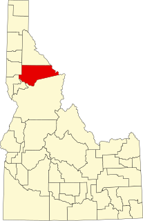
This is a list of the National Register of Historic Places listings in Clearwater County, Idaho.

National Register of Historic Places listings in Edgecombe County, North Carolina

This list includes properties and districts listed on the National Register of Historic Places in Edgecombe County, North Carolina, United States. Click the "Map of all coordinates" link to the right to view a Google map of all properties and districts with latitude and longitude coordinates in the table below.

National Register of Historic Places listings in Pitt County, North Carolina

This list includes properties and districts listed on the National Register of Historic Places in Pitt County, North Carolina. Click the "Map of all coordinates" link to the right to view an online map of all properties and districts with latitude and longitude coordinates in the table below.

National Register of Historic Places listings in Dare County, North Carolina

This list includes properties and districts listed on the National Register of Historic Places in Dare County, North Carolina. Click the "Map of all coordinates" link to the right to view a Google map of all properties and districts with latitude and longitude coordinates in the table below.

National Register of Historic Places listings in Austin County, Texas

This is a list of the National Register of Historic Places listings in Austin County, Texas.

National Register of Historic Places listings in Bosque County, Texas

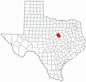
This is a list of the National Register of Historic Places listings in Bosque County, Texas.

National Register of Historic Places listings in Wright County, Missouri

This is a list of the National Register of Historic Places listings in Wright County, Missouri.

This is a list of the National Register of Historic Places listings in Olympic National Park.

National Register of Historic Places listings in Brazoria County, Texas

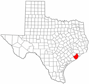
This is a list of the National Register of Historic Places listings in Brazoria County, Texas.

National Register of Historic Places listings in Lubbock County, Texas

List of NRHP-registered historic places in Lubbock County, Texas

National Register of Historic Places listings in Montgomery County, Missouri

This is a list of the National Register of Historic Places listings in Montgomery County, Missouri.

National Register of Historic Places listings in Webb County, Texas

This is a list of the National Register of Historic Places listings in Webb County, Texas.

National Register of Historic Places listings in Armstrong County, Texas

This is a list of the National Register of Historic Places listings in Armstrong County, Texas.

National Register of Historic Places listings in Willacy County, Texas

This is a list of the National Register of Historic Places listings in Willacy County, Texas.

National Register of Historic Places listings in Hale County, Texas

This is a list of the National Register of Historic Places listings in Hale County, Texas.

References

  1. The latitude and longitude information provided in this table was derived originally from the National Register Information System, which has been found to be fairly accurate for about 99% of listings. Some locations in this table may have been corrected to current GPS standards.
  2. National Park Service, United States Department of the Interior, "National Register of Historic Places: Weekly List Actions", retrieved February 25, 2022.
  3. Numbers represent an alphabetical ordering by significant words. Various colorings, defined here, differentiate National Historic Landmarks and historic districts from other NRHP buildings, structures, sites or objects.
  4. The eight-digit number below each date is the number assigned to each location in the National Register Information System database, which can be viewed by clicking the number.
  5. Federal and state laws and practices restrict general public access to information regarding the specific location of this resource. In some cases, this is to protect archeological sites from vandalism, while in other cases it is restricted at the request of the owner. See: Knoerl, John; Miller, Diane; Shrimpton, Rebecca H. (1990), Guidelines for Restricting Information about Historic and Prehistoric Resources, National Register Bulletin, National Park Service, U.S. Department of the Interior, OCLC   20706997 .
  6. "National Register Information System". National Register of Historic Places . National Park Service. November 2, 2013.
  7. Adams, Robert McCormick. "The Kimmswick Bone Bed". Missouri Archaeologist 15.4 (1953): 40-56.