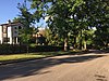
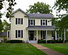
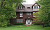
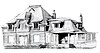
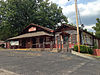
[3] Name on the Register Image Date listed [4] Location City or town Description 1 #1 Fairway Upload image January 4, 2024 (# 100009688 11869 Fairlind Dr. 38°32′03″N 90°23′23″W / 38.5342°N 90.3896°W / 38.5342; -90.3896 (#1 Fairway ) Sunset Hills House adjacent to Sunset Country Club 's first hole. 2 Affton High School Affton High School August 12, 2010 (# 10000551 8520 Mackenzie Rd. 38°33′26″N 90°19′18″W / 38.5572°N 90.3217°W / 38.5572; -90.3217 (Affton High School ) Affton 3 Archambault House Archambault House May 13, 1976 (# 76002178 603 rue St. Denis 38°47′43″N 90°19′29″W / 38.7953°N 90.3247°W / 38.7953; -90.3247 (Archambault House ) Florissant 4 Assumption Greek Orthodox Church Assumption Greek Orthodox Church September 23, 1980 (# 80004389 6900 Delmar Boulevard 38°39′22″N 90°18′41″W / 38.6561°N 90.3114°W / 38.6561; -90.3114 (Assumption Greek Orthodox Church ) University City 5 John C. and Georgie Atwood House John C. and Georgie Atwood House May 20, 2018 (# 100002428 100 S. Clay Ave. 38°44′35″N 90°18′02″W / 38.7430°N 90.3005°W / 38.7430; -90.3005 (John C. and Georgie Atwood House ) Ferguson 6 August Aubuchon House August Aubuchon House September 12, 1979 (# 79003648 1002 St. Louis 38°47′30″N 90°19′17″W / 38.7917°N 90.3214°W / 38.7917; -90.3214 (August Aubuchon House ) Florissant 7 Baptiste G. Aubuchon House Baptiste G. Aubuchon House May 6, 1976 (# 76002179 450 rue St. Jacques 38°47′33″N 90°19′43″W / 38.7925°N 90.3286°W / 38.7925; -90.3286 (Baptiste G. Aubuchon House ) Florissant 8 Ball-Essen Farmstead Historic District Ball-Essen Farmstead Historic District December 28, 2001 (# 01001378 749 Babler Park Dr. 38°37′36″N 90°40′25″W / 38.6267°N 90.6736°W / 38.6267; -90.6736 (Ball-Essen Farmstead Historic District ) Wildwood 9 Bank of St. Ann Upload image October 9, 2020 (# 100005661 10449 St. Charles Rock Rd. 38°43′45″N 90°23′03″W / 38.7293°N 90.3841°W / 38.7293; -90.3841 (Bank of St. Ann ) St. Ann 10 Barretts Tunnels Barretts Tunnels December 8, 1978 (# 78003138 3015 Barrett Station Rd. 38°34′11″N 90°27′53″W / 38.5697°N 90.4647°W / 38.5697; -90.4647 (Barretts Tunnels ) Kirkwood 11 Barteau House Barteau House September 12, 1979 (# 79003649 305 N. Costello 38°47′16″N 90°19′20″W / 38.7878°N 90.3222°W / 38.7878; -90.3222 (Barteau House ) Florissant 12 Barton House Barton House September 12, 1979 (# 79003650 680 St. Catherine 38°47′30″N 90°19′36″W / 38.7917°N 90.3267°W / 38.7917; -90.3267 (Barton House ) Florissant 13 Dr. Samuel A. Bassett Office and Residence Dr. Samuel A. Bassett Office and Residence February 3, 1993 (# 92001866 1200 S. Big Bend Boulevard 38°37′52″N 90°19′08″W / 38.6311°N 90.3189°W / 38.6311; -90.3189 (Dr. Samuel A. Bassett Office and Residence ) Richmond Heights 14 Romanzo N. Bayley House Romanzo N. Bayley House October 3, 2002 (# 02001086 419 E. Argonne 38°34′53″N 90°23′55″W / 38.5814°N 90.3986°W / 38.5814; -90.3986 (Romanzo N. Bayley House ) Kirkwood 15 Beaumont-Tyson Quarry District Upload image October 10, 1974 (# 74001079 Address restricted [5] Crescent Hills 212 acres (86 ha) area which extends also into Jefferson County [6] 16 Bellecourt Apartments Bellecourt Apartments September 16, 2002 (# 02000983 1107-1123 Bellevue Ave. 38°37′51″N 90°18′45″W / 38.6308°N 90.3125°W / 38.6308; -90.3125 (Bellecourt Apartments ) Richmond Heights 17 Bennett Avenue Historic District Bennett Avenue Historic District March 20, 2008 (# 08000228 7901-8027 Bennett Ave. and 1221-1282 Laclede Station Rd. 38°37′55″N 90°19′45″W / 38.6319°N 90.3291°W / 38.6319; -90.3291 (Bennett Avenue Historic District ) Richmond Heights 18 Louis Auguste Benoist House Louis Auguste Benoist House June 23, 1969 (# 69000317 7802 Genesta St. 38°34′09″N 90°18′45″W / 38.5692°N 90.3125°W / 38.5692; -90.3125 (Louis Auguste Benoist House ) Affton 19 Beverly Theater Beverly Theater August 4, 2005 (# 05000811 7740 Olive Boulevard 38°40′19″N 90°20′14″W / 38.6719°N 90.3372°W / 38.6719; -90.3372 (Beverly Theater ) University City 20 Big Chief Restaurant Big Chief Restaurant April 2, 2003 (# 03000181 17352 Old Manchester Rd. 38°34′52″N 90°39′35″W / 38.5811°N 90.6597°W / 38.5811; -90.6597 (Big Chief Restaurant ) Wildwood 21 Gen. Daniel Bissell House Gen. Daniel Bissell House November 28, 1978 (# 78003135 10225 Bellefontaine Rd. 38°45′21″N 90°13′24″W / 38.7558°N 90.2233°W / 38.7558; -90.2233 (Gen. Daniel Bissell House ) Bellefontaine Neighbors 22 John P. and Dora Blake House John P. and Dora Blake House October 3, 2002 (# 02001087 549 N. Taylor 38°35′19″N 90°24′17″W / 38.588611°N 90.404722°W / 38.588611; -90.404722 (John P. and Dora Blake House ) Kirkwood 23 B'Nai Amoona Synagogue B'Nai Amoona Synagogue April 22, 1984 (# 84002698 524 Trinity Ave. 38°39′17″N 90°18′38″W / 38.6547°N 90.3106°W / 38.6547; -90.3106 (B'Nai Amoona Synagogue ) University City The building served the Congregation B'nai Amoona ; it is currently the Center of Creative Arts (COCA). 24 Bockwrath-Wiese House Bockwrath-Wiese House February 2, 1979 (# 79003676 St. Ferdinand Park 38°48′12″N 90°19′28″W / 38.803333°N 90.324444°W / 38.803333; -90.324444 (Bockwrath-Wiese House ) Florissant 25 Bonhomme Creek Archeological District Upload image November 21, 1974 (# 74002207 Straddling Wild Horse Creek Road between the Missouri River bluff and Bonhomme and Caulk's Creeks [7] Chesterfield 26 William Bopp House William Bopp House April 5, 2006 (# 06000218 12120 Old Big Bend Rd. 38°34′09″N 90°26′01″W / 38.569167°N 90.433611°W / 38.569167; -90.433611 (William Bopp House ) Kirkwood 27 Bouas House Bouas House September 12, 1979 (# 79003651 1290 St. Joseph 38°47′34″N 90°19′00″W / 38.792778°N 90.316667°W / 38.792778; -90.316667 (Bouas House ) Florissant 28 Brentmoor Park, Brentmoor and Forest Ridge District Brentmoor Park, Brentmoor and Forest Ridge District September 23, 1982 (# 82004716 Big Bend and Wydown Boulevards 38°38′36″N 90°19′19″W / 38.643333°N 90.321944°W / 38.643333; -90.321944 (Brentmoor Park, Brentmoor and Forest Ridge District ) Clayton 29 Burkhardt Historic District Burkhardt Historic District August 31, 2000 (# 00001011 16662-16678 Chesterfield Airport Rd.; also the even-numbered properties of 16626-16660 Chesterfield Airport Rd. 38°39′50″N 90°34′45″W / 38.663889°N 90.579167°W / 38.663889; -90.579167 (Burkhardt Historic District ) Chesterfield Second set of addresses represents a boundary increase of May 5, 2006 30 Dr. Leander W. Cape Buildings Dr. Leander W. Cape Buildings November 15, 2005 (# 05001283 7401-03 Hazel and 2737-47 Sutton 38°36′48″N 90°19′13″W / 38.613333°N 90.320278°W / 38.613333; -90.320278 (Dr. Leander W. Cape Buildings ) Maplewood 31 Carney-Keightley House Carney-Keightley House July 8, 2010 (# 10000460 930 Hawkins Rd. 38°30′07″N 90°28′56″W / 38.501944°N 90.482222°W / 38.501944; -90.482222 (Carney-Keightley House ) Fenton 32 Carrswold Historic District Carrswold Historic District September 9, 1982 (# 82004889 1-26 Carrswold Dr. 38°38′42″N 90°19′46″W / 38.645000°N 90.329444°W / 38.645000; -90.329444 (Carrswold Historic District ) Clayton 33 Casa Alvarez Casa Alvarez June 18, 1976 (# 76002180 289 rue St. Denis 38°47′48″N 90°19′43″W / 38.796667°N 90.328611°W / 38.796667; -90.328611 (Casa Alvarez ) Florissant 34 Central Webster Historic District Central Webster Historic District June 11, 1986 (# 86001329 Roughly bounded by E. and S. Cedar, Plant and W. Maple Aves., E. and W. Jackson Rd., and Gray Ave. 38°35′18″N 90°21′27″W / 38.588333°N 90.357500°W / 38.588333; -90.357500 (Central Webster Historic District ) Webster Groves 35 Charbonier Bluff Charbonier Bluff September 28, 1995 (# 95001100 Charbonier Rd. 38°48′52″N 90°23′04″W / 38.814444°N 90.384444°W / 38.814444; -90.384444 (Charbonier Bluff ) Hazelwood 36 Church Street Commercial District Church Street Commercial District August 23, 1984 (# 84002701 2-100 Church St. 38°44′42″N 90°18′17″W / 38.745000°N 90.304722°W / 38.745000; -90.304722 (Church Street Commercial District ) Ferguson 37 Judge Enos Clarke House Judge Enos Clarke House December 12, 2002 (# 02001088 503 E. Monroe 38°34′45″N 90°23′50″W / 38.579167°N 90.397222°W / 38.579167; -90.397222 (Judge Enos Clarke House ) Kirkwood 38 Claverach Park Claverach Park August 24, 2015 (# 15000537 Roughly bounded by Broadview, Claverach, Crestwood, Harcourt, Hillvale & Ridgemoor Drs., Clayton Rd., Wydown Blvd. 38°38′23″N 90°19′23″W / 38.6397°N 90.323°W / 38.6397; -90.323 (Claverach Park ) Clayton 39 Cold Water Cemetery Cold Water Cemetery May 19, 2004 (# 04000462 15290 Old Halls Ferry Rd. 38°50′05″N 90°16′59″W / 38.834722°N 90.283056°W / 38.834722; -90.283056 (Cold Water Cemetery ) Florissant 40 James H. and Marietta Comfort House James H. and Marietta Comfort House October 3, 2002 (# 02001089 235 E. Jefferson 38°34′57″N 90°24′10″W / 38.582500°N 90.402778°W / 38.582500; -90.402778 (James H. and Marietta Comfort House ) Kirkwood 41 Coral Court Motel Coral Court Motel April 25, 1989 (# 89000311 7755 Watson Rd. 38°34′20″N 90°20′05″W / 38.572222°N 90.334722°W / 38.572222; -90.334722 (Coral Court Motel ) Marlborough Demolished. [8] 42 Cori House Cori House October 2, 1986 (# 86002799 1080 N. Berry Rd. 38°35′55″N 90°22′35″W / 38.598611°N 90.376389°W / 38.598611; -90.376389 (Cori House ) Glendale 43 Cragwold Cragwold December 30, 2009 (# 09001175 1455 Cragwold Rd. 38°33′20″N 90°26′16″W / 38.555669°N 90.437656°W / 38.555669; -90.437656 (Cragwold ) Kirkwood Estate house and nature reserve of Edwin A. Lemp , on the Meramec River 44 Crescent Quarry Archeological Site Upload image February 12, 1971 (# 71001030 South of the Meramec River in the Crescent Hills [7] 38°31′41″N 90°34′16″W / 38.528056°N 90.571111°W / 38.528056; -90.571111 (Crescent Quarry Archeological Site ) Crescent A square 1,000 feet (300 m) on each side; part of a large district of five square miles [7] 45 Curtiss-Wright Aeroplane Factory Curtiss-Wright Aeroplane Factory September 6, 2016 (# 16000586 130 Banshee Rd. 38°45′29″N 90°21′56″W / 38.757928°N 90.365523°W / 38.757928; -90.365523 (Curtiss-Wright Aeroplane Factory ) Hazelwood 46 Rudolph and Dorothy C. Czufin House Rudolph and Dorothy C. Czufin House July 12, 2002 (# 02000792 24 Dielman Rd. 38°39′14″N 90°22′32″W / 38.653889°N 90.375556°W / 38.653889; -90.375556 (Rudolph and Dorothy C. Czufin House ) Ladue 47 Delmar Loop-Parkview Gardens Historic District Delmar Loop-Parkview Gardens Historic District February 16, 1984 (# 84002624 Roughly bounded by Kingsland Ave., North Dr., Delmar Boulevard, and Eastgate 38°39′21″N 90°18′15″W / 38.655833°N 90.304167°W / 38.655833; -90.304167 (Delmar Loop-Parkview Gardens Historic District ) University City 48 Des Peres Presbyterian Church Des Peres Presbyterian Church April 14, 1978 (# 78003137 2255 Geyer Rd. 38°37′22″N 90°25′12″W / 38.622778°N 90.42°W / 38.622778; -90.42 (Des Peres Presbyterian Church ) Frontenac 49 Donaldson Court Apartments Donaldson Court Apartments October 13, 1983 (# 83004032 601-615 Westgate Ave. 38°39′23″N 90°18′17″W / 38.656481°N 90.304645°W / 38.656481; -90.304645 (Donaldson Court Apartments ) University City 50 Douglas House Douglas House September 12, 1979 (# 79003652 801 St. Francois 38°47′32″N 90°19′26″W / 38.792222°N 90.323889°W / 38.792222; -90.323889 (Douglas House ) Florissant 51 Downtown Kirkwood Historic District Downtown Kirkwood Historic District October 28, 2009 (# 09000859 105-133 E. Argonne, 100-159 W. Argonne, 108-212 N. Clay, 105-140 E. Jefferson, and 100-161 W. Jefferson 38°34′55″N 90°24′24″W / 38.582083°N 90.406617°W / 38.582083; -90.406617 (Downtown Kirkwood Historic District ) Kirkwood 52 Dr. Edmund A. Babler Memorial State Park Historic District Dr. Edmund A. Babler Memorial State Park Historic District February 27, 1985 (# 85000539 Northwest of Grover 38°37′12″N 90°41′38″W / 38.620000°N 90.693889°W / 38.620000; -90.693889 (Dr. Edmund A. Babler Memorial State Park Historic District ) Grover 53 East Monroe Historic District East Monroe Historic District July 14, 2004 (# 04000695 Roughly bounded by Madison Ave., S. Holmes St., Scott Ave., and Smith St. 38°34′49″N 90°23′59″W / 38.580278°N 90.399722°W / 38.580278; -90.399722 (East Monroe Historic District ) Kirkwood 54 Fairfax House Fairfax House April 15, 2004 (# 04000280 9401 Manchester Rd. 38°36′43″N 90°21′45″W / 38.611944°N 90.3625°W / 38.611944; -90.3625 (Fairfax House ) Rock Hill 55 Farmers State Bank of Chesterfield Farmers State Bank of Chesterfield August 20, 1999 (# 99001019 16676-78 Old Chesterfield Rd. 38°39′50″N 90°34′46″W / 38.663889°N 90.579444°W / 38.663889; -90.579444 (Farmers State Bank of Chesterfield ) Chesterfield 56 Father Dickson Cemetery Father Dickson Cemetery October 6, 2021 (# 14001125 845 South Sappington Rd. 38°33′54″N 90°23′05″W / 38.5650°N 90.3847°W / 38.5650; -90.3847 (Father Dickson Cemetery ) Crestwood 57 Ferguson School Central School Ferguson School Central School September 7, 1984 (# 84002706 201 Wesley Ave. 38°44′34″N 90°18′28″W / 38.742778°N 90.307778°W / 38.742778; -90.307778 (Ferguson School Central School ) Ferguson 58 Charles W. Ferguson House Charles W. Ferguson House September 18, 1984 (# 84002704 15-17 W. Lockwood Ave. 38°35′35″N 90°21′26″W / 38.593056°N 90.357222°W / 38.593056; -90.357222 (Charles W. Ferguson House ) Webster Groves 59 George W. and Virginia Fishback House George W. and Virginia Fishback House October 3, 2002 (# 02001090 440 E. Argonne 38°34′51″N 90°23′53″W / 38.580833°N 90.398056°W / 38.580833; -90.398056 (George W. and Virginia Fishback House ) Kirkwood 60 Fort Bellefontaine Fort Bellefontaine February 23, 2016 (# 16000031 Fort Belle Fontaine County Park [9] 38°49′36″N 90°12′59″W / 38.826667°N 90.216389°W / 38.826667; -90.216389 (Fort Bellefontaine ) Black Jack 61 Louisa Garrett House Louisa Garrett House June 27, 2007 (# 07000618 280 Washington St. 38°47′35″N 90°19′54″W / 38.793192°N 90.331803°W / 38.793192; -90.331803 (Louisa Garrett House ) Florissant 62 Glen Echo Historic District Glen Echo Historic District October 25, 2007 (# 07001105 3401 Lucas-Hunt Rd., 7202-48 Henderson Ave., and 7200-71 St. Andrews Pl. 38°42′04″N 90°17′52″W / 38.701161°N 90.297892°W / 38.701161; -90.297892 (Glen Echo Historic District ) Normandy and Glen Echo Park 63 Goldbeck House Goldbeck House September 12, 1979 (# 79003653 1061 St. Louis 38°47′30″N 90°19′14″W / 38.791667°N 90.320556°W / 38.791667; -90.320556 (Goldbeck House ) Florissant 64 Gorlock Building Gorlock Building November 8, 1984 (# 84000256 101-113 W. Lockwood Ave. 38°35′35″N 90°21′33″W / 38.593056°N 90.359167°W / 38.593056; -90.359167 (Gorlock Building ) Webster Groves 65 Grace Episcopal Church Grace Episcopal Church April 12, 1982 (# 82004720 Taylor and Argonne Sts. 38°34′51″N 90°24′12″W / 38.580833°N 90.403333°W / 38.580833; -90.403333 (Grace Episcopal Church ) Kirkwood 66 Greenwood Cemetery Greenwood Cemetery February 24, 2004 (# 04000090 6571 St. Louis Ave. 38°41′19″N 90°17′19″W / 38.688611°N 90.288611°W / 38.688611; -90.288611 (Greenwood Cemetery ) Hillsdale 67 Greenwood Historic District Greenwood Historic District April 12, 2006 (# 06000246 3500-3540 Greenwood and 7518 St. Elmo 38°36′24″N 90°19′14″W / 38.606667°N 90.320556°W / 38.606667; -90.320556 (Greenwood Historic District ) Maplewood 68 Haarstick-Whittemore Houses Haarstick-Whittemore Houses September 20, 1982 (# 82004717 6420 and 6440 Forsyth Boulevard 38°38′46″N 90°18′32″W / 38.646111°N 90.308889°W / 38.646111; -90.308889 (Haarstick-Whittemore Houses ) Clayton Presently home to the Whittemore House Club 69 Egbert W. Halsey Cottage Egbert W. Halsey Cottage October 3, 2002 (# 02001091 126 E. Washington 38°35′04″N 90°24′17″W / 38.584444°N 90.404722°W / 38.584444; -90.404722 (Egbert W. Halsey Cottage ) Kirkwood 70 Harry Hammerman House Harry Hammerman House March 20, 2008 (# 08000227 219 Graybridge Ln. 38°39′24″N 90°22′21″W / 38.656667°N 90.3725°W / 38.656667; -90.3725 (Harry Hammerman House ) Ladue 71 Hampton Park Hampton Park December 21, 2005 (# 05001437 1108-1176 Center Dr., 1012-1259 Hampton Park Dr., 1140-1173 Hillside Dr., 7914-8045 Park Dr., and 8000-8062 South Dr. 38°38′09″N 90°19′54″W / 38.635833°N 90.331667°W / 38.635833; -90.331667 (Hampton Park ) Richmond Heights 72 Martin Franklin Hanley House Martin Franklin Hanley House May 27, 1971 (# 71001029 7600 Westmoreland Ave. 38°39′06″N 90°19′54″W / 38.651667°N 90.331667°W / 38.651667; -90.331667 (Martin Franklin Hanley House ) Clayton 73 Hanson House Hanson House September 12, 1979 (# 79003654 704 Ste. Catherine 38°47′30″N 90°19′34″W / 38.791667°N 90.326111°W / 38.791667; -90.326111 (Hanson House ) Florissant 74 Hawken House Hawken House February 16, 1970 (# 70000858 1155 S. Rock Hill Rd. 38°34′24″N 90°22′34″W / 38.573333°N 90.376111°W / 38.573333; -90.376111 (Hawken House ) Webster Groves 75 Nathaniel Hawthorne Elementary School Nathaniel Hawthorne Elementary School October 2, 2017 (# 100001688 1351 N. Hanley Rd. 38°40′29″N 90°19′50″W / 38.674816°N 90.330549°W / 38.674816; -90.330549 (Nathaniel Hawthorne Elementary School ) University City 76 Henry Avenue Historic District Henry Avenue Historic District January 8, 2003 (# 02001692 120, 210, 211, 218, 220, 226, 230, 310, 314, and 320 Henry Ave. 38°35′33″N 90°31′06″W / 38.5925°N 90.518333°W / 38.5925; -90.518333 (Henry Avenue Historic District ) Manchester 77 Hi-Pointe-De Mun Historic District Hi-Pointe-De Mun Historic District May 7, 2005 (# 05000370 Roughly bounded by S. Skinker Boulevard, Clayton Rd., Seminary Place, De Mun Ave., and Northwood Ave.; also roughly bounded by Clayton Rd., De Mun Ave., San Bonita Ave., and Big Bend Boulevard 38°38′14″N 90°18′31″W / 38.637222°N 90.308611°W / 38.637222; -90.308611 (Hi-Pointe-De Mun Historic District ) Clayton Second set of boundaries represents a boundary increase of March 22, 2007 78 Hubecky House Hubecky House September 12, 1979 (# 79003674 917 Lafayette 38°47′46″N 90°19′24″W / 38.79624°N 90.32341°W / 38.79624; -90.32341 (Hubecky House ) Florissant Missouri French style house built in 1922. Adjacent to similar Meyer House . 79 Wilson Price Hunt House Wilson Price Hunt House September 23, 1980 (# 80004386 7717 Natural Bridge Rd. 38°42′25″N 90°18′15″W / 38.706944°N 90.304167°W / 38.706944; -90.304167 (Wilson Price Hunt House ) Normandy 80 J. Milton Turner School J. Milton Turner School August 22, 2002 (# 02000905 238 Meacham Ave., and 245 Saratoga Ave. 38°33′54″N 90°24′09″W / 38.565°N 90.4025°W / 38.565; -90.4025 (J. Milton Turner School ) Kirkwood 81 Jarville Jarville February 16, 1984 (# 84002634 1723 Mason Rd. 38°36′30″N 90°29′10″W / 38.608333°N 90.486111°W / 38.608333; -90.486111 (Jarville ) Between Manchester and Town and Country 82 Jefferson Barracks Historic District Jefferson Barracks Historic District February 1, 1972 (# 72001492 10 miles (16 km) south of St. Louis on the Mississippi River 38°29′53″N 90°16′28″W / 38.498056°N 90.274444°W / 38.498056; -90.274444 (Jefferson Barracks Historic District ) Lemay 83 Jefferson Barracks National Cemetery Jefferson Barracks National Cemetery July 9, 1998 (# 98000840 2900 Sheridan Rd. 38°29′50″N 90°17′24″W / 38.497222°N 90.29°W / 38.497222; -90.29 (Jefferson Barracks National Cemetery ) Green Park 84 Jefferson-Argonne Historic District Jefferson-Argonne Historic District July 14, 2004 (# 04000696 Roughly defined as being both sides of Jefferson Ave. and the northern side of Argonne between Taylor St. and Holmes Ave. 38°34′53″N 90°23′49″W / 38.581389°N 90.396944°W / 38.581389; -90.396944 (Jefferson-Argonne Historic District ) Kirkwood 85 David Keith House David Keith House October 3, 2002 (# 02001094 116 N. Woodlawn 38°34′54″N 90°23′49″W / 38.581667°N 90.396944°W / 38.581667; -90.396944 (David Keith House ) Kirkwood 86 Kirkwood Missouri Pacific Depot Kirkwood Missouri Pacific Depot July 5, 1985 (# 85001476 W. Argonne Dr. at Kirkwood Rd. 38°34′54″N 90°24′29″W / 38.581667°N 90.408056°W / 38.581667; -90.408056 (Kirkwood Missouri Pacific Depot ) Kirkwood 87 Robert Koch Hospital Robert Koch Hospital October 31, 1984 (# 84000206 4101 Koch Rd. 38°28′57″N 90°17′05″W / 38.4825°N 90.284722°W / 38.4825; -90.284722 (Robert Koch Hospital ) Oakville Demolished in 1989. [10] 88 Kramer House Kramer House September 12, 1979 (# 79003675 520 Ste. Catherine 38°47′33″N 90°19′40″W / 38.7925°N 90.327778°W / 38.7925; -90.327778 (Kramer House ) Florissant 89 Russell and Ruth Goetz Kraus House Russell and Ruth Goetz Kraus House January 31, 1997 (# 96001595 120 N. Ballas Rd. 38°34′57″N 90°26′31″W / 38.5825°N 90.441944°W / 38.5825; -90.441944 (Russell and Ruth Goetz Kraus House ) Kirkwood 90 Kreienkamp Store Kreienkamp Store May 5, 2000 (# 00000439 19160 Melrose Rd. 38°34′19″N 90°43′15″W / 38.571944°N 90.720833°W / 38.571944; -90.720833 (Kreienkamp Store ) Wildwood 91 Kuehn House Kuehn House September 12, 1979 (# 79003655 410 S. Harrison 38°47′30″N 90°19′52″W / 38.79158°N 90.33098°W / 38.79158; -90.33098 (Kuehn House ) Florissant Finest example of Missouri German architecture in the area. 92 Ladue Estates Ladue Estates May 26, 2010 (# 09000901 1-80 Ladue Estates Dr. 38°39′18″N 90°25′44″W / 38.655022°N 90.428872°W / 38.655022; -90.428872 (Ladue Estates ) Creve Coeur 93 Lance House Lance House September 12, 1979 (# 79003656 508 St. Antoine 38°47′45″N 90°19′31″W / 38.795833°N 90.325278°W / 38.795833; -90.325278 (Lance House ) Florissant 94 Marcus Laramie House Marcus Laramie House September 12, 1979 (# 79003657 929 St. Denis 38°47′35″N 90°19′16″W / 38.793056°N 90.321111°W / 38.793056; -90.321111 (Marcus Laramie House ) Florissant 95 Wilson Larimore House Wilson Larimore House February 10, 1989 (# 88003244 11510 Larimore Rd. 38°46′27″N 90°12′05″W / 38.774167°N 90.201389°W / 38.774167; -90.201389 (Wilson Larimore House ) Bellefontaine Neighbors 96 Theodore Link Historic Buildings Theodore Link Historic Buildings September 11, 1980 (# 80004390 7100, 7104, and 7108 Delmar Boulevard 38°39′24″N 90°19′01″W / 38.656667°N 90.316944°W / 38.656667; -90.316944 (Theodore Link Historic Buildings ) University City 97 William Long Log House William Long Log House December 5, 1978 (# 78003136 9385 Pardee Rd. 38°32′47″N 90°21′51″W / 38.546389°N 90.364167°W / 38.546389; -90.364167 (William Long Log House ) Crestwood 98 The Lyceum The Lyceum April 3, 1979 (# 79003206 14318 Manchester Road 38°35′33″N 90°30′37″W / 38.5925°N 90.510278°W / 38.5925; -90.510278 (The Lyceum ) Manchester 99 Manchester Methodist Episcopal Church Manchester Methodist Episcopal Church February 10, 1983 (# 83001053 129 Woods Mill Rd. 38°35′41″N 90°30′34″W / 38.594722°N 90.509444°W / 38.594722; -90.509444 (Manchester Methodist Episcopal Church ) Manchester 100 Maplewood Commercial Historic District at Manchester and Sutton Maplewood Commercial Historic District at Manchester and Sutton December 20, 2006 (# 06001135 Roughly bounded by Manchester, Marietta, Marshall, and Sutton 38°36′53″N 90°19′06″W / 38.614722°N 90.318333°W / 38.614722; -90.318333 (Maplewood Commercial Historic District at Manchester and Sutton ) Maplewood 101 Maplewood Historic Commercial District Maplewood Historic Commercial District November 14, 2019 (# 100004603 7145-7233 & 7146-7192 Manchester Blvd., 7209-11 Lanham 38°36′55″N 90°18′43″W / 38.6153°N 90.3119°W / 38.6153; -90.3119 (Maplewood Historic Commercial District ) Maplewood 102 Marshall Place Historic District Marshall Place Historic District June 17, 1982 (# 82004726 Marshall Pl. 38°35′45″N 90°21′28″W / 38.595833°N 90.357778°W / 38.595833; -90.357778 (Marshall Place Historic District ) Webster Groves 103 Maryland Terrace Historic District Maryland Terrace Historic District September 3, 1998 (# 98001137 7001-7419 Maryland Ave. and 7001-7394 Westmoreland Dr. 38°39′03″N 90°19′22″W / 38.650833°N 90.322778°W / 38.650833; -90.322778 (Maryland Terrace Historic District ) University City 104 McGarry House McGarry House April 12, 1982 (# 82004724 6965 Pershing Ave. 38°39′10″N 90°18′51″W / 38.652778°N 90.314167°W / 38.652778; -90.314167 (McGarry House ) University City 105 Lizzie McLagan House Lizzie McLagan House October 3, 2002 (# 02001092 549 E. Argonne 38°34′52″N 90°23′44″W / 38.581111°N 90.395556°W / 38.581111; -90.395556 (Lizzie McLagan House ) Kirkwood 106 Patrick and Moire McMullen House Patrick and Moire McMullen House October 3, 2002 (# 02001093 212 W. Monroe 38°34′44″N 90°24′32″W / 38.578889°N 90.408889°W / 38.578889; -90.408889 (Patrick and Moire McMullen House ) Kirkwood 107 McPherson-Holland House McPherson-Holland House September 16, 1982 (# 82004719 115 Edwin Ave. 38°35′10″N 90°23′07″W / 38.586111°N 90.385278°W / 38.586111; -90.385278 (McPherson-Holland House ) Glendale 108 Meramec River U.S. 66 Bridge - J421 Meramec River U.S. 66 Bridge - J421 September 16, 2009 (# 09000888 Historic U.S. Route 66 spanning the Meramec River 38°30′20″N 90°35′31″W / 38.505556°N 90.591997°W / 38.505556; -90.591997 (Meramec River U.S. 66 Bridge - J421 ) Eureka Riveted Warren deck truss bridge 109 Meyer House Meyer House September 12, 1979 (# 79003658 915 N. Lafayette 38°47′46″N 90°19′25″W / 38.79606°N 90.32353°W / 38.79606; -90.32353 (Meyer House ) Florissant 1922-built Missouri French house adjacent to similar Hubecky House 110 Frank Moellring House Frank Moellring House September 12, 1979 (# 79003659 1002 Boone 38°47′42″N 90°19′13″W / 38.795°N 90.320278°W / 38.795; -90.320278 (Frank Moellring House ) Florissant 111 Moller House Moller House September 12, 1979 (# 79003660 300 Washington 38°47′34″N 90°19′51″W / 38.792778°N 90.330833°W / 38.792778; -90.330833 (Moller House ) Florissant 112 Moorlands Addition Apartment District Moorlands Addition Apartment District September 30, 2009 (# 09000787 Roughly bounded by Clayton Rd., Glenridge Ave., Wydown Boulevard, and both sides of Westwood Dr. 38°38′23″N 90°19′53″W / 38.639858°N 90.331439°W / 38.639858; -90.331439 (Moorlands Addition Apartment District ) Clayton 113 Mount Hope Cemetery Mount Hope Cemetery October 3, 2003 (# 03000994 1215 Lemay Ferry Rd. 38°32′02″N 90°17′29″W / 38.533889°N 90.291389°W / 38.533889; -90.291389 (Mount Hope Cemetery ) Lemay 114 Mudd's Grove Mudd's Grove April 5, 1984 (# 84002710 302 W. Argonne Dr. 38°34′52″N 90°24′39″W / 38.581111°N 90.410833°W / 38.581111; -90.410833 (Mudd's Grove ) Kirkwood 115 Joseph and Ann Murphy Residence Joseph and Ann Murphy Residence May 10, 2010 (# 10000246 7901 Stanford Ave. 38°39′46″N 90°20′31″W / 38.662694°N 90.341819°W / 38.662694; -90.341819 (Joseph and Ann Murphy Residence ) University City 116 John B. Myers House John B. Myers House December 13, 1974 (# 74002210 180 Dunn Rd.; also 108 Dunn Rd. 38°46′35″N 90°20′13″W / 38.776389°N 90.336944°W / 38.776389; -90.336944 (John B. Myers House ) Florissant 108 Dunn represents a boundary increase of September 19, 1977 117 Narrow Gauge Railroad Station Narrow Gauge Railroad Station September 12, 1979 (# 79003661 1060 St. Catherine 38°47′23″N 90°19′21″W / 38.789722°N 90.3225°W / 38.789722; -90.3225 (Narrow Gauge Railroad Station ) Florissant 118 New Mount Sinai Cemetery New Mount Sinai Cemetery December 22, 2005 (# 05001434 8430 Gravois Rd. 38°33′25″N 90°18′20″W / 38.556944°N 90.305556°W / 38.556944; -90.305556 (New Mount Sinai Cemetery ) Affton 119 Nicolay House Nicolay House September 12, 1979 (# 79003662 549 N. St. Jacques 38°47′36″N 90°19′42″W / 38.793333°N 90.328333°W / 38.793333; -90.328333 (Nicolay House ) Florissant 120 Nims Mansion Nims Mansion October 2, 2017 (# 100001689 2741 Finestown Rd. 38°24′35″N 90°19′27″W / 38.409609°N 90.324191°W / 38.409609; -90.324191 (Nims Mansion ) Oakville 121 Prof. Frances E. Nipher House Prof. Frances E. Nipher House October 3, 2002 (# 02001095 435 N. Harrison 38°35′08″N 90°24′41″W / 38.585556°N 90.411389°W / 38.585556; -90.411389 (Prof. Frances E. Nipher House ) Kirkwood 122 North Taylor Avenue Historic District North Taylor Avenue Historic District August 7, 2012 (# 12000474 Roughly bounded by Manchester Rd., E. Adams, & N. Taylor Aves. 38°35′32″N 90°24′14″W / 38.592087°N 90.403969°W / 38.592087; -90.403969 (North Taylor Avenue Historic District ) Kirkwood 123 Norwood Hills Country Club Norwood Hills Country Club February 25, 2005 (# 05000084 1 Norwood Hills Country Club Dr. 38°43′20″N 90°17′02″W / 38.722222°N 90.283889°W / 38.722222; -90.283889 (Norwood Hills Country Club ) Ferguson 124 Old Ferguson West Historic District Old Ferguson West Historic District November 2, 2011 (# 11000784 Roughly bounded by Carson Rd., Harvey & Tiffin Aves. & Florissant Rd. 38°44′33″N 90°18′32″W / 38.7425°N 90.308889°W / 38.7425; -90.308889 (Old Ferguson West Historic District ) Ferguson 125 Old Stone Church Old Stone Church April 13, 1973 (# 73002274 Conway Rd. at White Rd. 38°38′57″N 90°31′33″W / 38.64915°N 90.525772°W / 38.64915; -90.525772 (Old Stone Church ) Chesterfield 126 Old Webster Historic District Old Webster Historic District August 4, 2004 (# 04000782 Roughly bounded by Allen Ave., Elm Ave., W. Lockwood Ave. and the Missouri Pacific RR Tracks; also 50-54 W Moody Ave. 38°35′43″N 90°21′32″W / 38.595278°N 90.358889°W / 38.595278; -90.358889 (Old Webster Historic District ) Webster Groves Second set of addresses represent a boundary increase approved November 13, 2018. 127 Olive Chapel African Methodist Episcopal Church Olive Chapel African Methodist Episcopal Church April 20, 2004 (# 04000345 309 S. Harrison Ave. 38°34′44″N 90°24′39″W / 38.578889°N 90.410833°W / 38.578889; -90.410833 (Olive Chapel African Methodist Episcopal Church ) Kirkwood 128 Orrville Historic District Orrville Historic District October 18, 2003 (# 03001053 526 and 538 Eatherton Rd. 38°38′14″N 90°39′34″W / 38.637222°N 90.659444°W / 38.637222; -90.659444 (Orrville Historic District ) Wildwood 129 Osage Hills School Osage Hills School May 24, 2007 (# 07000462 1110 Glenwood S 38°33′55″N 90°26′30″W / 38.565278°N 90.441667°W / 38.565278; -90.441667 (Osage Hills School ) Kirkwood 130 Theodore A. Pappas House Theodore A. Pappas House February 14, 1979 (# 79003208 865 Masonridge Rd. 38°38′13″N 90°29′03″W / 38.636944°N 90.484167°W / 38.636944; -90.484167 (Theodore A. Pappas House ) Creve Coeur 131 George M. Park House Upload image January 26, 2023 (# 100008572 440 South Price Rd. 38°38′58″N 90°22′00″W / 38.6494°N 90.3666°W / 38.6494; -90.3666 (George M. Park House ) Ladue 132 Parkview Historic District Parkview Historic District March 14, 1986 (# 86000788 Roughly bounded by Delmar Ave., Skinker and Millbrook Boulevards, and Mellville Ave. 38°39′08″N 90°18′11″W / 38.652222°N 90.303056°W / 38.652222; -90.303056 (Parkview Historic District ) University City 133 Parkview Towers Upload image July 24, 2024 (# 100010557 701 Westgate Avenue 38°39′25″N 90°18′17″W / 38.6569°N 90.3047°W / 38.6569; -90.3047 (Parkview Towers ) University City 134 Pasadena Hills Historic District Pasadena Hills Historic District December 4, 2004 (# 04001281 Bounded by the city limits of Pasadena Hills 38°42′26″N 90°19′55″W / 38.707222°N 90.331944°W / 38.707222; -90.331944 (Pasadena Hills Historic District ) Pasadena Hills 135 Elisha and Lucy Patterson Farmstead Historic District Elisha and Lucy Patterson Farmstead Historic District November 17, 2004 (# 04001242 15505 New Halls Ferry Rd. 38°49′38″N 90°18′38″W / 38.827222°N 90.310556°W / 38.827222; -90.310556 (Elisha and Lucy Patterson Farmstead Historic District ) Florissant 136 Payne-Gentry House Payne-Gentry House April 17, 1979 (# 79003202 4211 Fee Fee Rd. 38°44′50″N 90°23′59″W / 38.747222°N 90.399722°W / 38.747222; -90.399722 (Payne-Gentry House ) Bridgeton 137 Peters House Peters House September 12, 1979 (# 79003664 903 rue St. Francois 38°47′28″N 90°19′21″W / 38.791111°N 90.3225°W / 38.791111; -90.3225 (Peters House ) Florissant 138 Pine Lawn Carriage House Pine Lawn Carriage House February 16, 1984 (# 84002666 6292-94 Stillwell Dr. 38°41′27″N 90°16′48″W / 38.690833°N 90.28°W / 38.690833; -90.28 (Pine Lawn Carriage House ) Pine Lawn Demolished [11] 139 Samuel Plant House Samuel Plant House April 19, 1984 (# 84002711 800 Cella Rd. 38°38′39″N 90°22′20″W / 38.644167°N 90.372222°W / 38.644167; -90.372222 (Samuel Plant House ) Ladue 140 Pond School Pond School November 6, 2012 (# 12000910 17123 Manchester Rd. 38°34′40″N 90°38′48″W / 38.577681°N 90.646613°W / 38.577681; -90.646613 (Pond School ) Wildwood 141 Price School Price School February 14, 1985 (# 85000285 Price School Lane 38°38′20″N 90°22′20″W / 38.638889°N 90.372222°W / 38.638889; -90.372222 (Price School ) Ladue Demolished [12] 142 Charles S. and Mary Warder Rannells House Charles S. and Mary Warder Rannells House September 20, 2006 (# 06000861 2200 Bredell 38°37′16″N 90°19′34″W / 38.621111°N 90.326111°W / 38.621111; -90.326111 (Charles S. and Mary Warder Rannells House ) Maplewood 143 Red Cedar Inn Red Cedar Inn April 2, 2003 (# 03000180 1047 East Osage 38°28′53″N 90°43′02″W / 38.481389°N 90.717222°W / 38.481389; -90.717222 (Red Cedar Inn ) Pacific 144 Reeb House Reeb House September 12, 1979 (# 79003665 446 St. Charles 38°47′41″N 90°19′58″W / 38.794722°N 90.332778°W / 38.794722; -90.332778 (Reeb House ) Florissant 145 Theodore and Lena Richter House Theodore and Lena Richter House December 5, 2002 (# 02001096 229 S. Van Buren 38°34′46″N 90°25′00″W / 38.579444°N 90.416667°W / 38.579444; -90.416667 (Theodore and Lena Richter House ) Kirkwood 146 Rickelman House Rickelman House September 12, 1979 (# 79003666 680 Washington 38°47′28″N 90°19′38″W / 38.791111°N 90.327222°W / 38.791111; -90.327222 (Rickelman House ) Florissant 147 Otto Ripple Agency Otto Ripple Agency September 12, 1979 (# 79003663 755 rue St. Francois 38°47′33″N 90°19′28″W / 38.7925°N 90.324444°W / 38.7925; -90.324444 (Otto Ripple Agency ) Florissant 148 George R. and Elsie Robinson House George R. and Elsie Robinson House October 31, 2002 (# 02001268 443 E. Argonne 38°34′53″N 90°23′52″W / 38.581389°N 90.397778°W / 38.581389; -90.397778 (George R. and Elsie Robinson House ) Kirkwood 149 Rock House, Edgewood Children's Center Rock House, Edgewood Children's Center September 9, 1982 (# 82004727 330 N. Gore 38°35′55″N 90°21′53″W / 38.598611°N 90.364722°W / 38.598611; -90.364722 (Rock House, Edgewood Children's Center ) Webster Groves 150 Rockwood Court Apartments Rockwood Court Apartments April 5, 2006 (# 06000222 330 W. Lockwood 38°35′42″N 90°21′51″W / 38.595°N 90.364167°W / 38.595; -90.364167 (Rockwood Court Apartments ) Webster Groves 151 Rott School Rott School September 15, 2005 (# 05001022 9455 Rott Rd. 38°32′10″N 90°25′19″W / 38.536111°N 90.421944°W / 38.536111; -90.421944 (Rott School ) Sunset Hills 152 St. Ferdinand Central Historic District St. Ferdinand Central Historic District September 12, 1979 (# 79003647 Roughly bounded by rue St. Francois, rue St. Ferdinand, and rue St. Denis, and Lafayette St. 38°47′41″N 90°19′38″W / 38.794722°N 90.327222°W / 38.794722; -90.327222 (St. Ferdinand Central Historic District ) Florissant 153 St. Ferdinand's Shrine Historic District St. Ferdinand's Shrine Historic District September 12, 1979 (# 79003759 Between Cold Water and Fountain Creeks 38°47′47″N 90°20′02″W / 38.796389°N 90.333889°W / 38.796389; -90.333889 (St. Ferdinand's Shrine Historic District ) Florissant 154 St. Stanislaus Seminary St. Stanislaus Seminary September 22, 1972 (# 72001491 700 Howdershell Rd. 38°32′15″N 90°17′16″W / 38.5375°N 90.287778°W / 38.5375; -90.287778 (St. Stanislaus Seminary ) Florissant 155 St. Vincent's Hospital St. Vincent's Hospital April 12, 1982 (# 82004722 7301 St. Charles Rock Rd. 38°41′32″N 90°18′23″W / 38.692222°N 90.306389°W / 38.692222; -90.306389 (St. Vincent's Hospital ) Normandy 156 Sancta Maria in Ripa Sancta Maria in Ripa October 11, 2022 (# 100008257 320 East Ripa Ave. 38°31′27″N 90°16′19″W / 38.5242°N 90.2719°W / 38.5242; -90.2719 (Sancta Maria in Ripa ) Lemay 157 Joseph Sappington House Joseph Sappington House October 14, 1982 (# 82000589 Southwest of Affton at 10734 Clearwater Drive 38°32′15″N 90°21′21″W / 38.5375°N 90.355833°W / 38.5375; -90.355833 (Joseph Sappington House ) Affton 158 Thomas J. Sappington House Thomas J. Sappington House June 28, 1974 (# 74002209 1015 S. Sappington Rd. 38°33′51″N 90°23′05″W / 38.564167°N 90.384722°W / 38.564167; -90.384722 (Thomas J. Sappington House ) Crestwood 159 Zephaniah Sappington House Zephaniah Sappington House September 18, 1980 (# 80004384 Originally located south of Crestwood at 11145 Gravois Rd. 38°32′29″N 90°22′08″W / 38.541389°N 90.368889°W / 38.541389; -90.368889 (Zephaniah Sappington House ) Crestwood Now known as the Sappington-Dressel House, the original house was dismantled and moved to Defiance, Missouri where it was acquired and completely reconstructed by Lindenwood University . [13] 160 Saratoga Lanes Building Saratoga Lanes Building January 29, 2008 (# 07001492 2725 Sutton Boulevard 38°36′48″N 90°19′13″W / 38.613333°N 90.320278°W / 38.613333; -90.320278 (Saratoga Lanes Building ) Maplewood 161 Schmidt House Schmidt House September 12, 1979 (# 79003667 359 St. Jean 38°47′33″N 90°19′50″W / 38.7925°N 90.330556°W / 38.7925; -90.330556 (Schmidt House ) Florissant 162 Schoonover House Schoonover House September 12, 1979 (# 79003668 983 St. Antoine 38°47′38″N 90°19′13″W / 38.793889°N 90.320278°W / 38.793889; -90.320278 (Schoonover House ) Florissant 163 Seven Gables Building Seven Gables Building July 16, 1985 (# 85001564 18-26 N. Meramec 38°39′04″N 90°20′21″W / 38.651111°N 90.339167°W / 38.651111; -90.339167 (Seven Gables Building ) Clayton See Meier and Comfort for more information. 164 Shanley Building Shanley Building September 20, 1982 (# 82004718 7800 Maryland Ave. 38°39′05″N 90°20′13″W / 38.651389°N 90.336944°W / 38.651389; -90.336944 (Shanley Building ) Clayton 165 Sioux Passage Park Archeological Site Upload image July 24, 1974 (# 74002211 Address Restricted Florissant 166 Smith House Smith House September 12, 1979 (# 79003669 310 Florissant Rd. 38°47′17″N 90°19′22″W / 38.788056°N 90.322778°W / 38.788056; -90.322778 (Smith House ) Florissant 167 Stroer House Stroer House September 12, 1979 (# 79003670 700 Aubuchon 38°47′26″N 90°19′04″W / 38.790556°N 90.317778°W / 38.790556; -90.317778 (Stroer House ) Florissant 168 Sutter-Meyer House Sutter-Meyer House April 12, 1982 (# 82004725 6826 Chamberlain Court 38°39′50″N 90°18′41″W / 38.663889°N 90.311389°W / 38.663889; -90.311389 (Sutter-Meyer House ) University City 169 Taille de Noyer Taille de Noyer January 10, 1980 (# 80004385 1 rue Taille de Noyer 38°46′17″N 90°18′36″W / 38.771389°N 90.31°W / 38.771389; -90.31 (Taille de Noyer ) Florissant 170 Tebeau House Tebeau House September 12, 1979 (# 79003671 250 St. Catherine 38°47′39″N 90°19′53″W / 38.794167°N 90.331389°W / 38.794167; -90.331389 (Tebeau House ) Florissant Missouri German architecture 171 Marvin Tebeau House Marvin Tebeau House September 12, 1979 (# 79003672 449 St. Joseph 38°47′52″N 90°19′32″W / 38.797778°N 90.325556°W / 38.797778; -90.325556 (Marvin Tebeau House ) Florissant Missouri French architecture 172 Thornhill Thornhill July 18, 1974 (# 74002208 Olive Street Rd. in Faust County Park 38°40′06″N 90°32′44″W / 38.668333°N 90.545556°W / 38.668333; -90.545556 (Thornhill ) Chesterfield 173 Rosalie Tilles Park Rosalie Tilles Park April 19, 2018 (# 100002336 9551 Litzsinger Rd. 38°37′10″N 90°21′57″W / 38.619375°N 90.365722°W / 38.619375; -90.365722 (Rosalie Tilles Park ) Ladue 174 G.W. Tolhurst House G.W. Tolhurst House October 3, 2002 (# 02001097 345 E. Argonne 38°34′53″N 90°24′01″W / 38.581389°N 90.400278°W / 38.581389; -90.400278 (G.W. Tolhurst House ) Kirkwood 175 Tuxedo Park Christian Church Tuxedo Park Christian Church November 8, 2006 (# 06000988 700 Tuxedo Boulevard 38°36′12″N 90°20′30″W / 38.603333°N 90.341667°W / 38.603333; -90.341667 (Tuxedo Park Christian Church ) Webster Groves 176 Tuxedo Park Station Tuxedo Park Station March 22, 1984 (# 84002713 643 Glen Rd. 38°36′08″N 90°20′52″W / 38.602222°N 90.347778°W / 38.602222; -90.347778 (Tuxedo Park Station ) Webster Groves Former Missouri Pacific Railroad depot. 177 U.S. Army Publications Distribution Center U.S. Army Publications Distribution Center October 5, 2015 (# 15000704 1655 Woodson Rd. 38°41′00″N 90°21′53″W / 38.6834°N 90.3648°W / 38.6834; -90.3648 (U.S. Army Publications Distribution Center ) Overland 178 University City Education District University City Education District January 31, 1985 (# 85000172 7400 and 7401 Balson Ave. and 951 N. Hanley Rd. 38°39′53″N 90°19′51″W / 38.664722°N 90.330833°W / 38.664722; -90.330833 (University City Education District ) University City 179 University City Plaza University City Plaza March 7, 1975 (# 75002092 Roughly bounded by Delmar Boulevard and Trinity, Harvard, and Kingsland Aves. 38°39′27″N 90°18′34″W / 38.6575°N 90.309444°W / 38.6575; -90.309444 (University City Plaza ) University City City Hall (University City, Missouri) is a contributing property 180 University Heights Subdivision Number One University Heights Subdivision Number One September 23, 1980 (# 80004391 Roughly bounded by Delmar Boulevard and Yale, Dartmouth, and Harvard Aves. 38°39′34″N 90°18′38″W / 38.659444°N 90.310556°W / 38.659444; -90.310556 (University Heights Subdivision Number One ) University City 181 Elijah J. Unsell House Elijah J. Unsell House December 12, 2002 (# 02001098 615 E. Monroe 38°34′44″N 90°23′39″W / 38.578889°N 90.394167°W / 38.578889; -90.394167 (Elijah J. Unsell House ) Kirkwood 182 James W. and Mary Way House James W. and Mary Way House December 12, 2002 (# 02001099 305 N. Harrison 38°35′00″N 90°24′42″W / 38.583333°N 90.411667°W / 38.583333; -90.411667 (James W. and Mary Way House ) Kirkwood 183 Webster College-Eden Theological Seminary Collegiate District Webster College-Eden Theological Seminary Collegiate District December 28, 1982 (# 82000590 470 and 475 E. Lockwood Ave. 38°36′02″N 90°20′39″W / 38.600556°N 90.344167°W / 38.600556; -90.344167 (Webster College-Eden Theological Seminary Collegiate District ) Webster Groves 184 Webster Park Residential Historic District Webster Park Residential Historic District December 30, 2008 (# 08001260 Roughly bounded by Newport, Bompart, E. Lockwood, N. Maple, and Glen Rd. 38°35′43″N 90°20′55″W / 38.595372°N 90.3487°W / 38.595372; -90.3487 (Webster Park Residential Historic District ) Webster Groves 185 White Haven; Ulysses S. Grant National Historic Site White Haven; Ulysses S. Grant National Historic Site April 4, 1979 (# 79003205 9060 Whitehaven Dr. or 7400 Grant Street 38°33′06″N 90°21′06″W / 38.551792°N 90.351683°W / 38.551792; -90.351683 (White Haven; Ulysses S. Grant National Historic Site ) Grantwood Village 186 Wildwood House Wildwood House April 5, 2006 (# 06000234 40 Dames Court 38°44′42″N 90°17′30″W / 38.745°N 90.291667°W / 38.745; -90.291667 (Wildwood House ) Ferguson 187 Williams Creek Archeological District Upload image November 23, 1977 (# 77001527 Address Restricted St. Louis 188 Withington House Withington House September 12, 1979 (# 79003673 502 St. Marie 38°47′24″N 90°19′49″W / 38.79°N 90.330278°W / 38.79; -90.330278 (Withington House ) Florissant Missouri German architecture 189 Wydown-Forsyth District Wydown-Forsyth District May 23, 1988 (# 88000628 Roughly bounded by Forsyth, Skinker Boulevard, Fauquier, Wydown Terrace Dr., and University Ln. 38°38′38″N 90°18′25″W / 38.643889°N 90.306944°W / 38.643889; -90.306944 (Wydown-Forsyth District ) Clayton