Grand Gulf State Park (Missouri)

Last updated

Grand Gulf State Park
Grand Gulf cave 1-02Aug07.jpg
Water entering this cave reappears nine miles (14 km) away at Mammoth Spring.
USA Missouri relief location map.svg
Red pog.svg
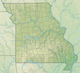
Location in Missouri
Usa edcp relief location map.png
Red pog.svg
Grand Gulf State Park (Missouri) (the United States)
Location Oregon County, Missouri, United States
Coordinates 36°32′39″N91°38′48″W / 36.54417°N 91.64667°W / 36.54417; -91.64667 [1]
Area321.96 acres (130.29 ha) [2]
Elevation646 ft (197 m) [1]
Established1984 [3]
Administered by Missouri Department of Natural Resources
Visitors57,524(in 2022) [4]
Website Official website OOjs UI icon edit-ltr-progressive.svg

Grand Gulf State Park is a state-operated, privately owned and publicly accessible, geologic preserve near Thayer, Missouri, United States, encompassing a forked canyon that is the remnant of an ancient collapsed dolomite cave system. [5] The land that is now the park was acquired by conservationist Leo Drey (1917–2015) before becoming part of the Missouri state parks system. The 322-acre (130 ha) state park has been operated by the Missouri Department of Natural Resources under a lease agreement with the L-A-D Foundation since 1984. [6] Grand Gulf was declared a National Natural Landmark in 1971 as an excellent example of karst topography and underground stream piracy. [7] A 60-acre (24 ha) portion of the park was designated by the state as the Grand Gulf Natural Area in 1986. [8]
Contents

Description

The Grand Gulf is nearly 1 mile (1.6 km) long and up to 130 feet (40 m) deep with sheer sides. An uncollapsed part of the original cavern roof spans 250 feet (76 m), creating one of the largest natural bridges in Missouri. A watershed of 28 square miles (73 km2) feeds into the gulf which itself drains into a cave entrance at its eastern end. [6] Dye traces have shown that water entering the cave in Grand Gulf emerges 1 to 4 days later at Mammoth Spring in Arkansas, 9 miles (14 km) distant. [9]

Facilities

The park has picnicking facilities and two trails for viewing the gulf. The park's heavy foliage makes fall and winter the best viewing seasons. [10]

References

  1. 1 2 "Grand Gulf". Geographic Names Information System . United States Geological Survey, United States Department of the Interior.
  2. "Data Sheet: Grand Gulf State Park" (PDF). Missouri Department of Natural Resources. November 2017. Retrieved December 29, 2024.
  3. "State Park Land Acquisition Summary". Missouri State Parks. Retrieved April 21, 2018.
  4. "Missouri State Park Attendance For January - December, 2022" (PDF). Missouri State Parks. February 3, 2023.
  5. "Grand Gulf State Park". Missouri Department of Natural Resources. Retrieved September 29, 2014.
  6. 1 2 "Grand Gulf State Park: General Information". Missouri Department of Natural Resources. Retrieved October 7, 2015.
  7. "Grand Gulf". National Natural Landmarks Program. National Park Service. June 28, 2012. Retrieved April 21, 2018.
  8. "Grand Gulf Natural Area". Missouri Department of Conservation. Retrieved December 29, 2024.
  9. Beveridge, Thomas R. (1980). Geologic Wonders and Curiosities of Missouri. Rolla, Mo.: Missouri Division of Geology and Land Survey. pp. 335–344. Library of Congress Card Catalog No. 78-69968.
  10. "Grand Gulf State Park: Trails". Missouri Department of Natural Resources. Retrieved December 29, 2024.