| Merriam Peak | |
|---|---|
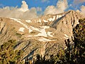
 North aspect | |
| Highest point | |
| Elevation | 13,103 ft (3,994 m) [1] |
| Prominence | 863 ft (263 m) [1] |
| Parent peak | Royce Peak (13,300 ft) [2] |
| Isolation | 0.69 mi (1.11 km) [2] |
| Listing | Sierra Peaks Section |
| Coordinates | 37°18′33″N118°45′55″W / 37.3091265°N 118.7652123°W [3] |
| Naming | |
| Etymology | Clinton Hart Merriam |
| Geography | |
 Merriam Peak Location in California  Merriam Peak Merriam Peak (the United States) | |
| Location | Fresno County California, U.S. |
| Parent range | Sierra Nevada [1] |
| Topo map | USGS Mount Hilgard |
| Geology | |
| Rock type | granitic |
| Climbing | |
| First ascent | July 14, 1933 |
| Easiest route | class 2+ [2] Royce-Merriam saddle |
Merriam Peak is a 13,103-foot-elevation (3,994-meter) mountain summit located in Fresno County in the Sierra Nevada mountain range in northern California, United States. [3] It is situated south of the Royce Lakes and north of French Canyon, in the John Muir Wilderness, on land managed by Sierra National Forest. It is set 0.7 miles (1.1 km) south-southeast of Royce Peak, the nearest higher neighbor. [1] Merriam Peak is the 129th highest summit in California. [2] Topographic relief is significant as it rises approximately 3,000 feet (910 meters) above French Canyon in one mile. This mountain was named in 1929 by the California State Geographic Board, and officially adopted in 1930 by the U.S. Board on Geographic Names to honor Dr. Clinton Hart Merriam (1855–1942), an American zoologist and naturalist, who served on the U.S. Board on Geographic Names from 1914 through 1925. [3]