
Costa Mesa is a city in Orange County, California. Since its incorporation in 1953, the city has grown from a semi-rural farming community of 16,840 to a primarily suburban and edge city with an economy based on retail, commerce, and light manufacturing. The population was 109,960 at the 2010 United States Census.
La Mesa is a city in Southern California, located 9 miles (14 km) east of Downtown San Diego in San Diego County. The population was 57,065 at the 2010 census, up from 54,749 at the 2000 census. Its civic motto is "the Jewel of the Hills."

San Diego Mesa College is a public, two year community college located in the community of Clairemont Mesa in the City of San Diego, California in the United States. It is the largest community college in the city of San Diego and part of the San Diego Community College District along with San Diego City College, San Diego Miramar College and San Diego Continuing Education. The college is known informally as Mesa College or Mesa.

Curecanti National Recreation Area is a National Park Service unit located on the Gunnison River in western Colorado. Established in 1965, Curecanti is responsible for developing and managing recreational facilities on three reservoirs, Blue Mesa Reservoir, Morrow Point Reservoir and Crystal Reservoir, constructed on the upper Gunnison River in the 1960s by the U.S. Bureau of Reclamation to better utilize the vital waters of the Colorado River and its major tributaries. A popular destination for boating and fishing, Curecanti offers visitors two marinas, traditional and group campgrounds, hiking trails, boat launches, and boat-in campsites. The state's premiere lake trout and Kokanee salmon fisheries, Curecanti is a popular destination for boating and fishing, and is also a popular area for ice-fishing in the winter months.

The San Diego-Imperial Council is headquartered in San Diego, California, and serves youth members and volunteer leaders through Scout units in San Diego and Imperial counties of Southern California, as well as a portion of Arizona.
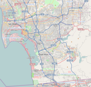
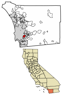
Otay Mesa is a community in the southern section of the city of San Diego, just north of the U.S.–Mexico border.

Kearny Mesa is a community in the central part of San Diego, California. It is located in the area of the city that is bounded by State Route 52 to the north, Interstate 805 to the west, Aero Drive to the South, and Interstate 15 to the east. Adjacent communities include Serra Mesa, Clairemont and Tierrasanta.

The Irvine Police Department is the local law enforcement agency of the city of Irvine, California, United States. The department's jurisdiction includes the entire city of Irvine, which covers nearly 70 square miles (180 km2) and a population of over 200,000, as well as the Orange County Great Park.

South Lake is an unincorporated community in the Kern River Valley, in Kern County, California. It is located 4.5 miles (7.2 km) west-southwest of Weldon, at an elevation of 2,887 feet (880 m).

Redonda Mesa is a mesa type formation located in the southern Santa Ana Mountains, near the Pacific Ocean in Southern California. It is located in an unincorporated area of southwestern Riverside County.
Rabbit Valley is a valley located in northwestern Mesa County, Colorado, United States. The area is generally used for paleontology, camping, hiking, mountain biking, off road vehicle recreation, and hunting. Rabbit Valley is accessed by Interstate 70/U.S. Route 6/U.S. Route 50.

Camp Connell is an unincorporated community in Calaveras County, California. It lies at an elevation of 4760 feet. The first post office was established in 1934 and landowner John F. Connell was appointed first postmaster; the place is named after him.
Camp Owens is an unincorporated community in the Kern River Valley of the Southern Sierra Nevada, in Kern County, California.
DeCamp is an unincorporated community in Mendocino County, California. It is located on the Northwestern Pacific Railroad 2 miles (3.2 km) north of Willits, at an elevation of 1342 feet.
Baldy Mesa is an unincorporated community in the Victor Valley of the Mojave Desert, within San Bernardino County, California.

Villa Grande, originally named Mesa Grande is an unincorporated community in Sonoma County, California, United States. Villa Grande is located on the Russian River 2.5 miles (4.0 km) southwest of Guerneville. Villa Grande has a post office (95486) which was established in 1921.
Otay Mesa West is a residential neighborhood in the southern section of San Diego. It borders Interstate 805 to the east, Interstate 5 to the west, and California State Route 905 to the south. It neighbors Ocean View Hills to the east, Nestor and Palm City to the west and Chula Vista to the north. The northern boundary of Otay Mesa West roughly coincides with the Otay River. Just north of the Otay River the community of Otay resides within the city of Chula Vista. Major thoroughfares include Palm Avenue, Coronado Avenue, Picador Boulevard, Del Sol Boulevard, Beyer Boulevard, and Beyer Way.

Juniper Mesa Wilderness is a 7,406-acre wilderness area in the Prescott National Forest in the U.S. state of Arizona. The mesa is about an hour's drive northwest of Prescott in the Juniper Mountains of Yavapai County. The wilderness varies in elevation from 5,600 to 7,000 feet. It is entirely within the Juniper Mountain quadrangle of the United States Geological Survey (USGS) topographic map.

Mesa Marin Raceway was a 0.5-mile (0.80 km) paved oval race track, located near the junction of CA 178 and CA 184, east of Bakersfield, California. It opened in 1977 and was owned by Marion Collins throughout its existence. The Collins family helped start the NASCAR Camping World Truck Series in 1995, and hosted nine races in that series at the track between 1995 and 2003. Mesa Marin also hosted 45 races for the Winston West Series and for NASCAR's Southwest Tour. The last race was held at Mesa Marin on October 16, 2005, as the track was sold for a housing development to be constructed on the site.

Filibuster Camp is the historic locale of a camp along the Gila River route of the Southern Emigrant Trail in Yuma County, Arizona, named in memory of a failed filibuster expedition to Sonora that began there in 1856.


