Swall Meadows, California | |
---|---|
Coordinates: 37°30′22″N118°38′34″W / 37.50611°N 118.64278°W | |
Country | United States |
State | California |
County | Mono |
Area | |
• Total | 4.462 sq mi (11.556 km2) |
• Land | 4.462 sq mi (11.556 km2) |
• Water | 0 sq mi (0 km2) 0% |
Elevation | 6,558 ft (1,999 m) |
Population (2020) [3] | |
• Total | 178 |
• Density | 40/sq mi (15/km2) |
Time zone | UTC-8 (Pacific (PST)) |
• Summer (DST) | UTC-7 (PDT) |
ZIP Code | 93514 |
Area codes | 442/760 |
FIPS code | 06-77430 |
GNIS feature IDs | 2583158, 2583158 |
U.S. Geological Survey Geographic Names Information System: Swall Meadows, California |
Swall Meadows is an unincorporated community and census-designated place (CDP) [2] in southern Mono County, California, United States. The population was 178 as of the 2020 census. [3] The community is residential, including second homes and a volunteer fire department, but no commercial development. The ZIP Code is 93514. [4] The community is inside area code 760.
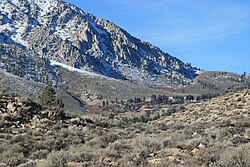
Swall Meadows sits partway up the Sherwin Grade below the Wheeler Crest of the eastern Sierra Nevada, at an elevation range of approximately 6,000 to 7,000 feet (1,800 to 2,100 m). It is in pinon-juniper/subalpine zone habitat, with views south along the Sierra Crest of Mt. Tom, and east across the Owens Valley to the White Mountains and Nevada. It is accessed from "old 395", or Lower Rock Creek Road. Swall Meadows is approximately 20 miles (32 km) north of Bishop and 25 miles (40 km) south of Mammoth Lakes (by highway distance). It also well known in the area as an important deer migration route for the Round Valley mule deer population, which cherish the grazing in the meadow and apple falls from the old orchard trees.[ citation needed ]
According to the United States Census Bureau, the Swall Meadows CDP covers an area of 4.5 square miles (12 km2), all of it land. [1] At the high, northwestern end is the old Sky Meadows Ranch, then houses and firehouse near the meadow, and at the southeast end a development known as Pinyon Ranch.
In addition to the predominant pinyon-juniper-sagebrush habitat, there are permanent and seasonal streams and the eponymous meadow with wetter-habitat vegetation such as Jeffrey pines, willows, stream and bog orchids, and the remnant trees of the old commercial apple orchard. In 2011 the Eastern Sierra Land Trust secured a conservation easement to protect 104 acres (42 ha) of the Swall Meadows meadow area (location of the historic homesite), for the continued benefit of the migrating mule deer. A number of other conservation easements have been completed in Swall Meadows since the ESLT organization was founded in 2001.
Between Paradise and Swall Meadows the old wagon road can be seen that climbed about 3,000 ft (910 m) up the Sherwin Grade from Owens Valley toward Crowley Lake.
The 2010 United States Census [5] reported that Swall Meadows had a population of 220. The population density was 49.3 inhabitants per square mile (19.0/km2). The racial makeup of Swall Meadows was 201 (91.4%) White, 0 (0.0%) African American, 3 (1.4%) Native American, 5 (2.3%) Asian, 0 (0.0%) Pacific Islander, 2 (0.9%) from other races, and 9 (4.1%) from two or more races. Hispanic or Latino of any race were 6 persons (2.7%).
The Census reported that 220 people (100% of the population) lived in households, 0 (0%) lived in non-institutionalized group quarters, and 0 (0%) were institutionalized.
There were 98 households, out of which 25 (25.5%) had children under the age of 18 living in them, 68 (69.4%) were opposite-sex married couples living together, 4 (4.1%) had a female householder with no husband present, 3 (3.1%) had a male householder with no wife present. There were 2 (2.0%) unmarried opposite-sex partnerships, and 0 (0%) same-sex married couples or partnerships. 21 households (21.4%) were made up of individuals, and 10 (10.2%) had someone living alone who was 65 years of age or older. The average household size was 2.24. There were 75 families (76.5% of all households); the average family size was 2.60.
The population was spread out, with 36 people (16.4%) under the age of 18, 6 people (2.7%) aged 18 to 24, 37 people (16.8%) aged 25 to 44, 99 people (45.0%) aged 45 to 64, and 42 people (19.1%) who were 65 years of age or older. The median age was 53.8 years. For every 100 females, there were 89.7 males. For every 100 females age 18 and over, there were 100.0 males.
There were 128 housing units at an average density of 28.7 per square mile (11.1/km2), of which 90 (91.8%) were owner-occupied, and 8 (8.2%) were occupied by renters. The homeowner vacancy rate was 0%; the rental vacancy rate was 0%. 201 people (91.4% of the population) lived in owner-occupied housing units and 19 people (8.6%) lived in rental housing units.
In the California State Legislature, Swall Meadows is in the 8th Senate District , represented by Democrat Angelique Ashby, and in the 5th Assembly District , represented by Republican Joe Patterson. [6]
In the United States House of Representatives, Swall Meadows is in California's 8th congressional district , represented by Democrat John Garamendi. [7]
On February 6, 2015, Swall Meadows and the neighboring community of Paradise were ravaged by the Round Fire, which burned 7,000 acres (28 km2). [8] The fire destroyed 40 homes: 39 homes in Swall Meadows and 1 home in Paradise. [9]
Magalia is an unincorporated community and census-designated place (CDP) in Butte County, California, United States. The population was 11,310 at the 2010 census.
Forest Meadows is a census-designated place (CDP) in Calaveras County, California, United States. The population was 1,249 at the 2010 census, up from 1,197 at the 2000 census.
Pollock Pines is a census-designated place (CDP) in El Dorado County, California, United States. It is part of the Sacramento–Arden-Arcade–Roseville Metropolitan Statistical Area. Pollock Pines lies at an elevation of 3,980 feet (1,210 m) in the Sierra Nevada. The population was 7,112 at the 2020 census, up from 6,871 at the 2010 census.
Dixon Lane-Meadow Creek is a census-designated place (CDP) in Inyo County, California, United States. The population was 2,645 at the 2010 census, down from 2,702 at the 2000 census.
Bodfish is a census-designated place (CDP) in the southern Kern River Valley of the Southern Sierra Nevada, in Kern County, California.
Boronda is an unincorporated community and census-designated place (CDP) in Monterey County, California, United States. The population was 1,760 at the 2020 census. Boronda is located directly west of Salinas and is named after José Eusebio Boronda, a Californio ranchero, and located on the lands of his Rancho Rincón del Sanjón.
Alta Sierra is a census-designated place (CDP) in Nevada County, California, United States. The population was 6,911 at the 2010 census, up from 6,522 at the 2000 census.
Meadow Vista is a census-designated place (CDP) in Placer County, California, United States. It is part of the Sacramento–Arden-Arcade–Roseville Metropolitan Statistical Area. The population was 3,217 at the 2010 census, up from 3,096 at the 2000 census.
Meadow Valley is a census-designated place (CDP) in Plumas County, California, United States. The population was 453 at the 2020 census, down from 464 at the 2010 census.
El Cerrito is a census-designated place (CDP) in Riverside County, California, United States. It is an unincorporated area mostly surrounded by the city of Corona. The population was 5,100 at the 2010 census, up from 4,590 at the 2000 census.
Bonsall is a census-designated place (CDP) in San Diego County, California. The population was 3,982 at the 2010 census, up from 3,401 at the 2000 census.
Hidden Meadows is a census-designated place (CDP) near Escondido in San Diego County, California. The population was 3,485 at the 2010 census, up from 3,463 at the 2000 census.
Stanford is a census-designated place (CDP) in the northwest corner of Santa Clara County, California, United States. It is the home of Stanford University. The population was 21,150 at the 2020 census.
Glen Ellen is a census-designated place (CDP) in Sonoma Valley, Sonoma County, California, United States. The population was 784 at the 2010 census, down from 992 at the 2000 census. Glen Ellen is the location of Jack London State Historic Park, Sonoma Valley Regional Park, and a former home of Hunter S. Thompson.
Cutler is a community and census-designated place (CDP) in Tulare County, California, United States. The population was 5,000 at the 2010 census, up from 4,491 at the 2000 census. The population as of 2019 was 5,214.
Colonial Pine Hills is a census-designated place (CDP) and unincorporated community in Pennington County, South Dakota, United States. The population was 1,903 at the 2020 census.
Paradise is an unincorporated community and census-designated place (CDP) that is the southernmost community in Mono County, California, United States. The population was 174 at the 2020 census.
Kennedy Meadows refers to a census-designated place (CDP) in Tulare County, California, United States part of the Springville-Johnsondale CCD, and consists of the community surrounding Kennedy Meadows. The CDP is located to the south-east of the Kennedy Meadows Campground. The 2020 United States census reported Kennedy Meadows's population of permanent residents at 58, up from 28 at the 2010 census. The census definition of the area may not precisely correspond to local understanding of the area with the same name.
Anderson is an unincorporated community and census-designated place (CDP) located within Mansfield Township, in Warren County, in the U.S. state of New Jersey, that was created as part of the 2010 United States census. As of the 2020 United States census, the CDP's population was 306, a decrease of 36 (-10.5%) from the 342 enumerated at the 2010 census.
Harmony is an unincorporated community and census-designated place (CDP) located within Harmony Township in Warren County, in the U.S. state of New Jersey, that was defined as part of the 2010 United States Census. As of the 2010 Census, the CDP's population was 441.